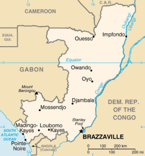
The Republic of the Congo is located in the western part of central Africa. Situated on the Equator, it is bordered by the Angolan exclave of Cabinda to the south (231 km), the Democratic Republic of the Congo to the north and west (1,229 km), the Central African Republic (487 km) and Cameroon (494 km) to the north and Gabon to the west (2,567 km). Congo has a 169 km long Atlantic coast with several important ports. The Republic of the Congo covers an area of 342,000 km², of which 341,500 km² is land while 500 km² is water. Congo claims 200 nautical miles (370 km) of territorial sea.

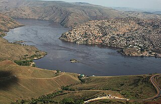
Brazzaville is the capital and largest city of the Republic of the Congo. Constituting the financial and administrative centre of the country, it is located on the north side of the Congo River, opposite Kinshasa, the capital city of the Democratic Republic of the Congo.

Leopold II was the second King of the Belgians from 1865 to 1909 and, through his own efforts, the owner and absolute ruler of the Congo Free State from 1885 to 1908.
Matadi is the chief sea port of the Democratic Republic of the Congo and the capital of the Kongo Central province, adjacent to the border with Angola. It had a population of 245,862 (2004). Matadi is situated on the left bank of the Congo River, 148 km (92 mi) from the mouth and 8 km (5.0 mi) below the last navigable point before the rapids that make the river impassable for a long stretch upriver. It was founded by Sir Henry Morton Stanley in 1879.

The Democratic Republic of the Congo, also known as Congo-Kinshasa, DR Congo, the DRC, the DROC, or the Congo, and formerly Zaire, is a country in Central Africa. It is, by area, the largest country in sub-Saharan Africa, the second-largest in all of Africa, and the 11th-largest in the world. With a population of around 105 million, the Democratic Republic of the Congo is the most populous officially Francophone country in the world, as well as the fourth-most populous country in Africa and the 15th-most populous country in the world. It is a member of the United Nations, Non-Aligned Movement, African Union, and COMESA. Since 2015, the Eastern DR Congo has been the site of an ongoing military conflict in Kivu. The capital and largest city is Kinshasa.

Équateur was a province in the northwest of the Belgian Congo and the successor Republic of the Congo, now known as Democratic Republic of the Congo. It had its origins in the Équateur District of the Congo Free State, the private property of King Leopold II of Belgium. It was upgraded to the status of a province in 1917. Between 1933 and 1947 it was named Coquilhatville. In 1962 it was divided into three smaller provinces, but there were recombined in 1966. Équateur was one of the eleven provinces of the Democratic Republic of the Congo until 2015, when it was split into the new, smaller Équateur province, as well as the Tshuapa, Mongala, Nord-Ubangi and Sud-Ubangi provinces.

South Kivu is one of 26 provinces of the Democratic Republic of the Congo. Its capital is Bukavu.

Kouilou is a department of the Republic of the Congo. Covering the country's coastline, it has an area of 13,650 square kilometres and at the start of 2007 it was home to about 91,955 people. The department borders Niari Department, the commune of Pointe-Noire, and internationally, Gabon and the Cabinda area of Angola. The regional capital was Hinda. Principal cities and towns include Madingo-Kayes and Mvouti.
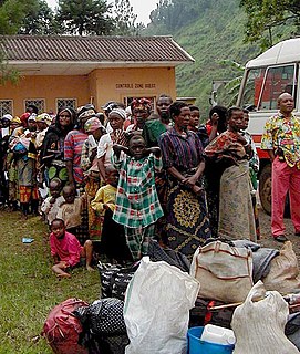
The Second Congo War began in the Democratic Republic of the Congo in August 1998, little more than a year after the First Congo War, and involved some of the same issues. The war officially ended in July 2003, when the Transitional Government of the Democratic Republic of the Congo took power. Although a peace agreement was signed in 2002, violence has continued in many regions of the country, especially in the east. Hostilities have continued since the ongoing Lord's Resistance Army insurgency, and the Kivu and Ituri conflicts.

Pointe-Noire is the second largest city in the Republic of the Congo, following the capital of Brazzaville, and an autonomous department since 2004. Before this date it was the capital of the Kouilou region. It is situated on a headland between Pointe-Noire Bay and the Atlantic Ocean. Pointe-Noire is the main commercial centre of the country and has a population of 715,334 (2007), expanding to well over 1 million when the entire metropolitan area is taken into account.

Boma is a port town on the Congo River, some 100 km upstream from the Atlantic Ocean, in the Kongo Central province of the Democratic Republic of the Congo, adjacent to the border with Angola. It had an estimated population of 162,521 in 2012.
Kananga, formerly known as Luluabourg or Luluaburg, is the capital city of the Kasai-Central Province in the Democratic Republic of the Congo and was the capital of the former Kasaï-Occidental Province. It is the fourth most populous urban area in the country, with an estimated population of 1,458,000 in 2020.

Équateur is one of the 21 new provinces of the Democratic Republic of the Congo created in the 2015 repartitioning. Équateur, Mongala, Nord-Ubangi, Sud-Ubangi, and Tshuapa provinces are the result of the dismemberment of the former Équateur province. The new province was formed from the Équateur district and the independently administered city of Mbandaka which retained its status as a provincial capital.
Guestwick railway station is a former station in Norfolk, England. It was constructed by the Midland and Great Northern Joint Railway in 1882 on the line between Melton Constable and Norwich City. It was closed in 1959. It served the village of Guestwick. It is on the path of Marriott's Way which follows the route of the old line.

The Republic of the Congo, also known as Congo-Brazzaville, the Congo Republic or simply either Congo or the Congo, is a country located in the western coast of Central Africa. The country is bordered to the west by Gabon, to its northwest by Cameroon and its northeast by the Central African Republic, to the southeast by the DR Congo, to its south by the Angolan exclave of Cabinda and to its southwest by the Atlantic Ocean. French is the official language of the Republic of the Congo.

Contemporary Whitehead Studies (CWS) is an interdisciplinary book series that publishes manuscripts from scholars with contemporary and innovative approaches to Whitehead studies. By publishing innovative and adventurous approaches to Whitehead’s philosophy that engage with the problems, promise, and ideas of the twenty-first century, Contemporary Whitehead Studies creates a vital and dynamic space for scholarly engagement.
The North Branch Marsh River is a 1.0-mile-long (1.6 km) tidal river in the town of Frankfort, Waldo County, Maine. It is a tributary of Marsh Bay, an arm of the tidal Penobscot River.
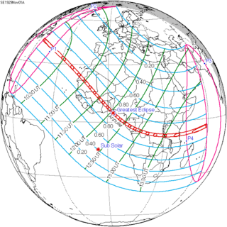
An annular solar eclipse occurred on November 1, 1929. A solar eclipse occurs when the Moon passes between Earth and the Sun, thereby totally or partly obscuring the image of the Sun for a viewer on Earth. An annular solar eclipse occurs when the Moon's apparent diameter is smaller than the Sun's, blocking most of the Sun's light and causing the Sun to look like an annulus (ring). An annular eclipse appears as a partial eclipse over a region of the Earth thousands of kilometres wide. Annularity was visible from Spanish Sahara, French West Africa, British Gold Coast, French Togoland including capital Lomé, Portuguese São Tomé and Príncipe, French Equatorial Africa including capital Brazzaville, Belgian Congo including capital Léopoldville, Northern Rhodesia, British Tanganyika including capital Dar es Salaam, and British Seychelles including capital Victoria.
Capital Region is one of the regions of Veracruz, Mexico.
Sotavento Region is one of the regions of Veracruz, Mexico.
