Vledder

Last updated • 1 min readFrom Wikipedia, The Free Encyclopedia
Vledder
Johannes de Doperkerk Vledder.jpg
Johannes de Doperkerk
Map NL - Westerveld - Vledder.png
The village centre (dark green) and the statistical district (light green) of Vledder in the municipality of Westerveld.
2010-NL-P03-Drenthe-positiekaart-gemnamen.jpg
Red pog.svg
Vledder
Location in the Netherlands
Netherlands location map.svg
Red pog.svg
Vledder
Vledder (Netherlands)
Coordinates: 52°51′20″N6°12′37″E / 52.85556°N 6.21028°E / 52.85556; 6.21028
Country Netherlands
Province Drenthe
Municipality Westerveld
Area
[1]
  Total12.68 km2 (4.90 sq mi)
Elevation
[2]
6 m (20 ft)
Population
 (2021) [1]
  Total1,960
  Density150/km2 (400/sq mi)
Time zone UTC+1 (CET)
  Summer (DST) UTC+2 (CEST)
Postal code
8381 [1]
Dialing code 0521

Vledder (Dutch pronunciation: [ˈvlɛdər] ) is a village in the Dutch province of Drenthe. It is a part of the municipality of Westerveld, and lies about 24 km northwest of Hoogeveen. It is located along the small river Vledder Aa.

Contents

History

Prehistoric settlements have been found in the area. Officially, the village of Vledder was started approximately in the year 500 AD. Situated in a desolate region, the village grew slowly. Around 900 AD seven farms were part of the community. In 1300 this number had risen to 20, at the end of the sixteenth century the farms numbered 29.

Vledder was a separate municipality between 1819 and 1998, when it became a part of Westerveld. [3]

Attractions

The village contains a museum of fake art, a Seamuseum, a Nazi labour camp for Jewish people (Kamp Vledder) and a museum of contemporary prints and glass. [4]

Related Research Articles

<span class="mw-page-title-main">Westerveld</span> Municipality in Drenthe, Netherlands

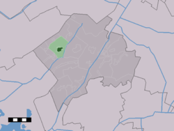
Westerveld is a municipality in the northeastern Netherlands.

<span class="mw-page-title-main">Heeswijk</span> Village in North Brabant, Netherlands

Heeswijk is a Dutch village. It is located in the province of North Brabant, in the south of the Netherlands.

<span class="mw-page-title-main">Dwingeloo</span> Village in Drenthe, Netherlands

Dwingeloo is a village halfway between Meppel and Assen in the Dutch province of Drenthe. It is a part of the municipality of Westerveld.

<span class="mw-page-title-main">Warffum</span> Village in Groningen, Netherlands

Warffum is a village in the Dutch province of Groningen. It is located in the municipality of Het Hogeland. It had a population of around 2,175 in January 2017.

<span class="mw-page-title-main">Diever</span> Village in Drenthe, Netherlands

Diever is a village in the Dutch province of Drenthe. It is a part of the municipality of Westerveld, and lies about 18 km northwest of Hoogeveen.

<span class="mw-page-title-main">Buggenum</span> Village in Limburg, Netherlands

Buggenum is a village in the Dutch province of Limburg. It was a part of the municipality of Haelen until 2007, when it merged into the municipality of Leudal. It lies about 5 km north of Roermond.

<span class="mw-page-title-main">Kamerik-Mijzijde</span> Hamlet in Utrecht, Netherlands

Kamerik-Mijzijde, also just called Mijzijde, is a hamlet in the Dutch province of Utrecht. It is a part of the municipality of Woerden, and lies about 4 km north of the city of Woerden. It consists of a number of farms some distance west from the villages of Kamerik and Kanis.

<span class="mw-page-title-main">Havelte</span> Village in Drenthe, Netherlands

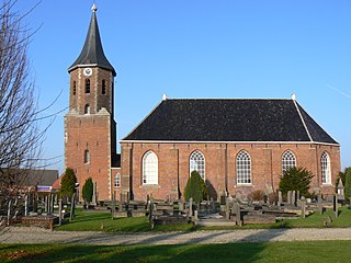
Havelte is a village in the Northeastern Netherlands. It is located in the municipality of Westerveld, Drenthe, about 60 km (37.2 mi) south-southwest of Groningen and 120 km (74.5 mi) northeast of Amsterdam. As of 1 January 2021, it had a population of 3,825.

<span class="mw-page-title-main">Vries, Netherlands</span> Village in Drenthe, Netherlands

Vries is a village in the Dutch province of Drenthe. It is a part of the municipality of Tynaarlo, and lies about 8 km north of Assen.

<span class="mw-page-title-main">Leerbroek</span> Village in Utrecht, Netherlands

Leerbroek is a village in the Dutch province of Utrecht. It is a part of the municipality of Vijfheerenlanden, and lies about 9 km (6 mi) northeast of Gorinchem.

<span class="mw-page-title-main">'s-Heerenhoek</span> Village in Zeeland, Netherlands

's-Heerenhoek is a village in the Dutch province of Zeeland. It is a part of the municipality of Borsele, and lies about 12 km east of Middelburg.

<span class="mw-page-title-main">Schermerhorn</span> Village in North Holland, Netherlands

Schermerhorn is a village in the Dutch province of North Holland. It is a part of the municipality of Alkmaar, and lies about 9 km south of Heerhugowaard.

<span class="mw-page-title-main">Asperen</span> Small city in Gelderland, Netherlands

Asperen is a small city in the Dutch province of Gelderland. It is a part of the municipality of West Betuwe, and lies about 10 km east of Gorinchem on the river Linge. It received city rights in 1313.

<span class="mw-page-title-main">Bath, Netherlands</span> Village in Zeeland, Netherlands

Bath is a small village and a former municipality in the Dutch province of Zeeland, lying on the north shore of the Western Scheldt. It is now located in the municipality of Reimerswaal, about 10 km southwest of Bergen op Zoom.

<span class="mw-page-title-main">Groede</span> Village in Zeeland, Netherlands

Groede is a village in the Dutch province of Zeeland. It is located about 5 km north of Oostburg in the municipality of Sluis.

<span class="mw-page-title-main">De Wijk</span> Village in Drenthe

De Wijk is a village in the Netherlands province of Drenthe. It is located in the municipality of De Wolden, and is about 7 km southeast of Meppel. It is home to Rijksmonument 39657, De Wieker Meule.

<span class="mw-page-title-main">Zuidwolde, Drenthe</span> Village in Drenthe, Netherlands

Zuidwolde is a village in the Dutch province of Drenthe. It is located in the municipality of De Wolden, about 7 km southwest of Hoogeveen. The village was integrated with Ruinen in 2008.

<span class="mw-page-title-main">Kantens</span> Village in Groningen, Netherlands

Kantens is a village in the Dutch province of Groningen. It is located in the municipality of Het Hogeland, about 16 km north of the city of Groningen. It had a population of around 965 including the surrounding area in January 2017.

<span class="mw-page-title-main">Nieuwolda</span> Village in Groningen, Netherlands

Nieuwolda is a village in the Dutch province of Groningen. It is located in the municipality of Oldambt, about 9 km southeast of Delfzijl.

<span class="mw-page-title-main">Genderen</span> Village in North Brabant, Netherlands

Genderen is a village in the Dutch province of North Brabant. It is located in the municipality of Altena.

References

  1. 1 2 3 "Kerncijfers wijken en buurten 2021". Central Bureau of Statistics. Retrieved 12 April 2022.
  2. "Postcodetool for 8381AA". Actueel Hoogtebestand Nederland (in Dutch). Het Waterschapshuis. 24 July 2019. Retrieved 12 April 2022.
  3. Ad van der Meer and Onno Boonstra, "Repertorium van Nederlandse gemeenten", KNAW, 2006. "KNAW > Publicaties > Detailpagina". Archived from the original on February 20, 2007. Retrieved December 3, 2009.
  4. Museum of Fake Art and Museum Contemporary Prints & Glass