Vledderveen, Drenthe

Last updated

Coordinates: 52°53′N6°11′E / 52.883°N 6.183°E / 52.883; 6.183

Geographic coordinate system Coordinate system

A geographic coordinate system is a coordinate system that enables every location on Earth to be specified by a set of numbers, letters or symbols. The coordinates are often chosen such that one of the numbers represents a vertical position and two or three of the numbers represent a horizontal position; alternatively, a geographic position may be expressed in a combined three-dimensional Cartesian vector. A common choice of coordinates is latitude, longitude and elevation. To specify a location on a plane requires a map projection.

Vledderveen
LocatieWesterveld.png
Map NL - Westerveld - Vledderveen.png
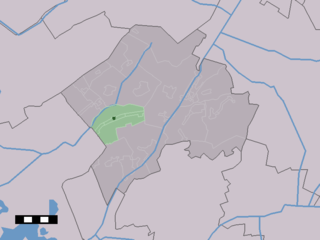
The village centre (dark green) and the statistical district (light green) of Vledderveen in the municipality of Westerveld.
Country Netherlands
Province Drenthe
Municipality Westerveld

Vledderveen is a village in the Dutch province of Drenthe. In 2001, the village of Vledderveen had 185 inhabitants. It is a part of the municipality of Westerveld, and lies about 26 km northwest of Hoogeveen.

Village Small clustered human settlement smaller than a town

A village is a clustered human settlement or community, larger than a hamlet but smaller than a town, with a population ranging from a few hundred to a few thousand. Though villages are often located in rural areas, the term urban village is also applied to certain urban neighborhoods. Villages are normally permanent, with fixed dwellings; however, transient villages can occur. Further, the dwellings of a village are fairly close to one another, not scattered broadly over the landscape, as a dispersed settlement.

Netherlands Constituent country of the Kingdom of the Netherlands in Europe

The Netherlands is a country located mainly in Northwestern Europe. The European portion of the Netherlands consists of twelve separate provinces that border Germany to the east, Belgium to the south, and the North Sea to the northwest, with maritime borders in the North Sea with Belgium, Germany and the United Kingdom. Together with three island territories in the Caribbean Sea—Bonaire, Sint Eustatius and Saba— it forms a constituent country of the Kingdom of the Netherlands. The official language is Dutch, but a secondary official language in the province of Friesland is West Frisian.

Drenthe Province of the Netherlands

Drenthe is a province of the Netherlands located in the northeastern part of the country. It is bordered by Overijssel to the south, Friesland to the west, Groningen to the north, and Germany to the east. In January 2017, it had a population of 491,867 and a total area of 2,683 km2 (1,036 sq mi).

The built-up area of the village was 0.11 km², and contained 74 residences. [1]

The statistical area "Vledderveen", which can also include the surrounding countryside, has a population of around 350. [2]

Related Research Articles

Hooglanderveen Place in Utrecht, Netherlands

Hooglanderveen is a village in the Dutch province of Utrecht. It is a part of the municipality of Amersfoort, and lies about 4 km northeast of Amersfoort. It is notable for the presence of a large catholic church.

Panheel Village in Limburg, Netherlands

Panheel is a town in the Dutch province of Limburg. It is a part of the municipality of Maasgouw, and lies about 9 km south-west of Roermond.

Breezand Place in North Holland, Netherlands

Breezand is a village in the Dutch province of North Holland. It is a part of the municipality of Hollands Kroon, which is very well known for its flowerbulbs, and lies about 7 km southeast of Den Helder.

Ankeveen Unincorporated community in North Holland, Netherlands

Ankeveen is a village in the Dutch province of North Holland. It is a part of the municipality of Wijdemeren, and lies about 5 km west of Bussum.

Wapse Place in Drenthe, Netherlands

Wapse is a town in the Dutch province of Drenthe. It is a part of the municipality of Westerveld, and lies about 21 km northwest of Hoogeveen.

Uffelte Place in Drenthe, Netherlands

Uffelte is a town in the Dutch province of Drenthe. It is a part of the municipality of Westerveld, and lies about 15 km west of Hoogeveen.

Wapserveen Place in Drenthe, Netherlands

Wapserveen is a town in the Dutch province of Drenthe. It is a part of the municipality of Westerveld, and lies about 21 km northwest of Hoogeveen.

Frederiksoord Place in Drenthe, Netherlands

Frederiksoord is a town in the Dutch province of Drenthe. It is a part of the municipality of Westerveld, and lies about 24 km northwest of Hoogeveen.

Nieuw-Balinge Place in Drenthe, Netherlands


Nieuw-Balinge is a village in the Dutch province of Drenthe. It is a part of the municipality of Midden-Drenthe, and lies about 10 km northeast of Hoogeveen.

Exloo Place in Drenthe, Netherlands

Exloo is a village in the Dutch province of Drenthe. It is a part of the municipality of Borger-Odoorn, and lies about 12 km north of Emmen.

Harbrinkhoek Place in Overijssel, Netherlands

Harbrinkhoek is a town in the Dutch province of Overijssel. It is a part of the municipality of Tubbergen, and lies about 5 km northeast of Almelo.

Langeveen Place in Overijssel, Netherlands

Langeveen is a town in the Dutch province of Overijssel. It is a part of the municipality of Tubbergen, and lies about 13 km north of Almelo.

Reutum Place in Overijssel, Netherlands

Reutum is a village in the Dutch province of Overijssel. It is a part of the municipality of Tubbergen, and lies about 10 km northwest of Oldenzaal.

Fleringen Place in Overijssel, Netherlands

Fleringen is a village in the Dutch province of Overijssel. It is a part of the municipality of Tubbergen, and lies about 10 km east of Almelo.

Zenderen Place in Overijssel, Netherlands

Zenderen is a town in the Dutch province of Overijssel. It is a part of the municipality of Borne, and lies about 6 km southeast of Almelo.

Poeldijk Place in South Holland, Netherlands

Poeldijk is a village in the Dutch province of South Holland. It is a part of the municipality of Westland, and lies about 8 km southwest of The Hague.

Schermerhorn Place in North Holland, Netherlands

Schermerhorn is a village in the Dutch province of North Holland. It is a part of the municipality of Alkmaar, and lies about 9 km south of Heerhugowaard.

Rumpt Place in Gelderland, Netherlands

Rumpt is a village in the Betuwe region in the Netherlands. It is a part of the municipality of Geldermalsen, and is situated about halfway between Utrecht and Den Bosch, on the Linge river.

Rhenoy Place in Gelderland, Netherlands

Rhenoy is a village in the Dutch province of Gelderland. It is a part of the municipality of Geldermalsen and is situated about 13 km east of Gorinchem, between Geldermalsen and Leerdam. The village has just over 670 inhabitants. In 2001 it had 510 inhabitants. The name of the village is probably derived from Rhenus (Rhine).

Tricht Place in Gelderland, Netherlands

Tricht is a town in the Dutch province of Gelderland. It is a part of the municipality of Geldermalsen, and lies about 10 km west of Tiel.

References

  1. Statistics Netherlands (CBS), Bevolkingskernen in Nederland 2001. (Statistics are for the continuous built-up area).
  2. Statistics Netherlands (CBS), Statline: Kerncijfers wijken en buurten 2003-2005. As of 1 January 2005.