Voxtrup

Last updated

Voxtrup is a district in the south-east of Osnabrück, Germany, with a population of roughly 7,000 residents. It is home to the Evangelical Margaretenkirche and the Catholic St. Antonius Kirche.

Osnabrück Place in Lower Saxony, Germany

Osnabrück is a city in the federal state of Lower Saxony in north-west Germany. It is situated in a valley penned between the Wiehen Hills and the northern tip of the Teutoburg Forest. With a population of 168,145 Osnabrück is one of the four largest cities in Lower Saxony. The city is the centrepoint of the Osnabrück Land region as well as the District of Osnabrück.

Germany Federal parliamentary republic in central-western Europe

Germany, officially the Federal Republic of Germany, is a country in Central and Western Europe, lying between the Baltic and North Seas to the north, and the Alps to the south. It borders Denmark to the north, Poland and the Czech Republic to the east, Austria and Switzerland to the south, France to the southwest, and Luxembourg, Belgium and the Netherlands to the west.

Contents

History

Voxtrup, Teufelssteine (Devil's Stones) - part of the Route of Megalithic Culture Teufelssteine 06.jpg
Voxtrup, Teufelssteine (Devil’s Stones) – part of the Route of Megalithic Culture
The Evangelical Margarethenkirche in Voxtrup Margarethenkirche Voxtrup.jpg
The Evangelical Margarethenkirche in Voxtrup

Voxtrup was first mentioned in records in 1088; however the earliest record only survives in the form of a transcription from the 14th century. It contains a legal notice stipulating that a nobleman named Eberhard was to transfer possession of an estate in Bevern to bishop Benno II in return for a payment of three pounds; its land would become part of the grounds of the Iburg monastery. The transaction was ultimately completed after the death of Benno, under his successor, Bishop Markwart. The case was heard at a place named “Vockestorp”. The court in Voccastorp (as it was named in a record dated 1090) was presumably located on the Mahlbrink around the area of the Gelshorn estate (today the Waldhof estate). Today’s Voxtrup finds its origins in the farming settlements of Molenseten, Düstrup, Hickingen and a settlement with the same name. In a record from 1147 the four settlements were named as a coherent body. It is almost certain that Voxtrup, Düstrup and Hickingen predate their first written records. Settlements are strongly believed to have existed in these areas in prehistoric times. The first estates in the farming settlements of Düstrup, Voxtrup and Hickingen had probably existed long before the Saxon-Westphalian regions were incorporated into the Frankish empire towards the end of the 8th century. Voxtrup is believed to have been named after the Fokko family. The district was originally home to three (or possibly five) separate estates: Arling, Hüdepohl, Werries, Brockmann and Strickmann.

Human prehistory is the period between the use of the first stone tools c. 3.3 million years ago by hominins and the invention of writing systems. The earliest writing systems appeared c. 5,300 years ago, but it took thousands of years for writing to be widely adopted, and it was not used in some human cultures until the 19th century or even until the present. The end of prehistory therefore came at very different dates in different places, and the term is less often used in discussing societies where prehistory ended relatively recently.

Voxtrup was incorporated into Osnabrück on 1 July 1972. [1] The northernmost part of the district used to lie within the former boundaries of Schinkel; this also used to be the location of the Lüstringen district railway station (until 1978), which was situated on the Osnabrück-Hannover line.

Schinkel is a district of Osnabrück, Germany, first mentioned in records in 1332. It is situated in the east of the city, into which it was incorporated on 1 April 1914. There are roughly 13,300 people in Schinkel.

Sport

The sports club “VfR Voxtrup” has existed since 1927, and today offers a wide range of sporting activities: namely badminton, football, basketball, mountain biking, tennis, table tennis, gymnastics, volleyball, basketball and hiking.

Volunteer fire brigade

The Osnabrück-Voxtrup volunteer fire brigade (Freiwillige Feuerwehr Osnabrück-Voxtrup) was founded in 1938, and today is based at Holsten-Mündruper-Straße in the heart of the district. Its fleet is currently made up of five modern emergency vehicles, three of these being large ones. Alongside standard firefighting the volunteer fire service has the additional duty of providing technical assistance at the scene of traffic accidents. The ELW 2 emergency control vehicle is utilised with the support of colleagues from Haste and the Neustadt; this is classified as special water transport and is well-equipped to provide expert technical aid, especially in the areas of building collapse and saving individuals buried under rubble. Alongside the emergency division there is also a youth fire brigade, established in 1983. On 21 August 2010 Voxtrup also established the first Kinderfeuerwehr (children’s fire brigade) in the city and district area.

Osnabrück (district) District in Lower Saxony, Germany

Osnabrück is a district (Landkreis) in the southwest of Lower Saxony, Germany. With 2,121 km² it is the second largest district of Lower Saxony.

Related Research Articles

German fire services

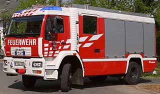
The Feuerwehr is a number of German fire departments. The responsible bodies for operating and equipping fire departments are the German communities ("Gemeinden") and cities ("Städte"). By law, they are required to operate fire-fighting forces. In cities, this is usually performed by the Fire Prevention Bureau, one of the higher-ranking authorities.

Widukindland human settlement in Germany

Widukindland is a district of Osnabrück, Germany. It is situated in the north-east of the city, on the slopes of the Schinkelberg. It arose from the former boundaries of Schinkel.

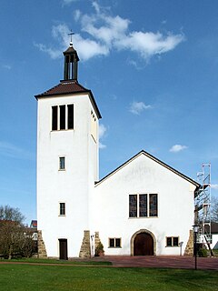
Schinkel-Ost is a district of Osnabrück, Germany. It originally lay within the former boundaries of Schinkel, which was incorporated into Osnabrück in 1914. Schinkel-Ost is home to roughly 3,500 residents. The evangelical Jakobuskirche, Catholic Rosenkranzkirche, “Blau-Weiß” (blue-white) sports team, Diesterwegschule and the Gesamtschule Schinkel are located in this district.

Schölerberg human settlement in Germany

Schölerberg is a district of Osnabrück, Germany, with approximately 13,900 residents.

Wüste is a district of the city of Osnabrück, Lower Saxony, Germany. With almost 14,000 residents it is the most populous district of Osnabruck. It is made up of the two subdivisions “Vordere Wüste” and “Hintere Wüste”. Its central location and good infrastructure make it an appealing residential area.

Weststadt (Osnabrück district) human settlement in Germany

Weststadt is a district of the city of Osnabrück with around 9,000 residents. It is located to the west of the Innenstadt district, on which it borders along with the districts of Westerberg, Wüste and Hellern.

Westerberg (Osnabrück district) human settlement in Germany

Westerberg is a district of Osnabrück, Lower Saxony, Germany, with roughly 8,700 residents. It is situated in the west of the city between Lotter Straße and Pagenstecherstraße. The districts bordering it are Eversburg, Hafen, Sonnenhügel, Innenstadt, Weststadt, Hellern and Atter. The border with Atter passes through the Rubbenbruchsee, part of a large local recreation area.

Hafen (Osnabrück) human settlement in Germany

Hafen (Harbour) is a district of Osnabrück, Lower Saxony. Germany. It is located in the north-west of the city and had a population of roughly 2,358 residents in 1,454 households as of late 2008. One year earlier the city had 2,372 residents. It covers an area of 407.2 hectares.

Hellern human settlement in Germany

Hellern is a district of Osnabrück with roughly 6,800 residents, located on the western and south-western borders of the city. It is bordered by the Atter, Westernerg, Weststadt, Wüste and Sutthausen districts; on its west and south-west it borders on the municipality of Lotte in North Rhine-Westphalia and also Hasbergen in the surrounding district of Osnabrück. Hellern is located in the valley of the small Düte river.

Dodesheide human settlement in Germany

Dodesheide is a town in the borough of Osnabrück, Germany; with a population of roughly 7,900 residents it is located to the north-east of the city. Its boundaries are delineated in the north by the Vehrter Landstraße, in the west by the landwehr – a former defensive line around the town consisting of a bank and ditches – in the south by the Sandbach and the Osnabrück-Bremen railway line; the city boundary itself marks its eastern border. It is made up of sections of the former districts of Schinkel and Haste.

Gartlage human settlement in Germany

Gartlage is a district of the city of Osnabrück, Lower Saxony, Germany. It is situated next to the Innenstadt.

Fledder human settlement in Germany

Fledder is a district in the east of Osnabrück, Germany, characterised by its large prevalence of industrial estates. Despite being the location of numerous businesses and large supermarkets the district has comparatively few residential buildings; its population is roughly 2,400.

Kalkhügel human settlement in Germany

Kalkhügel is a district of Osnabrück, Germany with a population of roughly 5,900 residents. It is home to both a Protestant and a Catholic church. There is also a school centre (Schulzentrum) located in the district.

Haste is a district in the north-east of Osnabrück, Germany. It is the fifth-largest district in the city on the River Hase, with a total land area of 788.8 hectares. Currently it has a population of about 6,600.

Sutthausen is a district of Osnabrück, Germany, with a population of about 4,500 residents. It is located in the south of the city, close to the Teutoburg Forest; it originally arose from two separate estates, Gut Sutthausen and Gut Wulften. The district has both Protestant and Catholic churches - respectively the Apostelkirche and the Marienkirche.

Atter (Osnabrück) human settlement in Germany

Atter is a district in the west of Osnabrück, Lower Saxony, Germany, with a population of 4,135 residents across 2,030 households. Covering an area of 1,075.9 hectares, it was incorporated into the city of Osnabrück on 1 July 1972. The districts on which it borders are Eversburg (NE), Westerberg (SE), and Hellern (S). On the west it borders on the municipality of Lotte in North Rhine-Westphalia; Autobahn 1 also passes through this area. The border with Westerberg runs through the Rubbenbruchsee, a local recreation area.

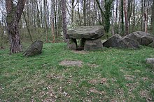
Darum/Gretesch/Lüstringen is a district of the city of Osnabrück, Lower Saxony, Germany. It is situated in the east of the city and is made up of these three localities, as well as land from within the former boundaries of Schinkel. It is home to a Protestant and a Catholic church – respectively the Petruskirche and the Marienkirche. There also used to be a railway station in this district – Osnabrück-Lüstringen, which was located on the Osnabrück–Hannover line and operated until 1978. The district is situated on the Route of Megalithic Culture.

Nahne is a district in the south of Osnabrück, Germany with a population of 2,241 residents, thus making it the city’s smallest district in terms of population. It covers an area of 4.854 km2.

References

  1. German Federal Statistical Office (ed.), Historisches Gemeindeverzeichnis für die Bundesrepublik Deutschland. Namens-, Grenz- und Schlüsselnummernänderungen bei Gemeinden, Kreisen und Regierungsbezirken vom 27. 5. 1970 bis 31. 12. 1982 (W. Kohlhammer GmbH, Stuttgart/Mainz, 1983), p.252 (ISBN   3-17-003263-1)

Coordinates: 52°15′10″N8°06′10″E / 52.2528°N 8.1028°E / 52.2528; 8.1028

Geographic coordinate system Coordinate system

A geographic coordinate system is a coordinate system that enables every location on Earth to be specified by a set of numbers, letters or symbols. The coordinates are often chosen such that one of the numbers represents a vertical position and two or three of the numbers represent a horizontal position; alternatively, a geographic position may be expressed in a combined three-dimensional Cartesian vector. A common choice of coordinates is latitude, longitude and elevation. To specify a location on a plane requires a map projection.