The Ibar, also known as the Ibër and Ibri, is a river that flows through eastern Montenegro, northern Kosovo and central Serbia, with a total length of 272 km (169 mi). The river begins in the Hajla mountain, in Rožaje, eastern Montenegro, and passes through southwestern Serbia and northern Kosovo, where it leads back into Serbia to flow into the West Morava river near Kraljevo, central Serbia.

Igman is a mountain plateau in central Bosnia and Herzegovina. Geologically, Igman is part of the Dinaric Alps and formed largely of secondary and tertiary sedimentary rock, mostly Limestone. It is located southwest of Sarajevo, bordering the Bjelašnica range in the south and west, Hadžići and Ilidža in the north, and the river Željeznica in the east. Igman's highest point, Crni vrh, west of the Malo Polje road, at an altitude of 1,510 metres, the homonym highest elevation on the east side of this road reaches an elevation of 1,502 metres. Most of Igman is covered with mixed forest with local pastures. Igman was the location of the lowest recorded temperature in the region, −43 °C (−45 °F). Igman was the site of extensive combat during the 1992-95 Siege of Sarajevo and certain areas, in particular the surroundings of former front lines, constitute a high mine risk.

Montenegro is a small, mountainous country in Southeast Europe. It borders Croatia, Bosnia and Herzegovina, Serbia, Kosovo, Albania and the Adriatic Sea. While being a small country at 13,812 km2 (5,333 sq mi), it is very diverse regarding the terrain configuration. Montenegro has 50 peaks of over 2,000 m (6,600 ft) in altitude.
Bijelo Polje is a town located in the Northern Region of Montenegro, situated along Lim River. It has an urban population of 12,900. It is the administrative, economic, cultural and educational centre of northern Montenegro.
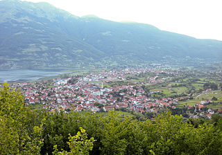
Plav is a town located in the Northern Region of Montenegro, situated along the Lim River, which originates from nearby Lake Plav, a glacial lake at the foot of the Prokletije mountains. It has a population of 3,717. Plav is the centre of Plav Municipality with a population of 9,050.
Gusinje is a small town in Montenegro in the northern region. According to the 2011 census, the town has a population of 1,673 and is the administrative center of Gusinje Municipality.

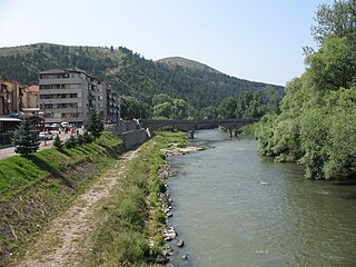
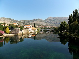
Rožaje is a town located in the Northern Region of Montenegro, situated along the Ibar river. The town is the cultural center of the Bosniaks in Montenegro.

Lake Plav is a lake in Plav municipality, in northeastern Montenegro.

Mojkovac Municipality is one of the municipalities of Montenegro. The municipality is located in northern Montenegro. The administrative center of the municipality is the town of Mojkovac.

Plav Municipality is one of the municipalities of Montenegro. It is located in Northern Montenegro. The center is the town of Plav. In February 2014, the southwestern third of the municipality seceded to form the Gusinje Municipality.
The Trebišnjica is a river in Bosnia and Herzegovina, and the right tributary of the Neretva. Before it was utilized for hydro exploitation via various hydrotechnical interventions and systems with different purposes, Trebišnjica used to be a sinking river, rising and sinking through its course before resurfacing at various places from the Neretva river below the Čapljina to the Adriatic coast, and along the coast from the Neretva Delta to Sutorina.
Bihor is a geographical region in northeastern Montenegro, located near Jagoče and northeast of Lopare. The area falls under three municipalities: Berane, Bijelo Polje and Petnjica. It is named after Bihor, a former medieval town once located near Bijelo Polje. The region is mainly inhabited by Bosniaks, with a minority of Serbs and Montenegrins.

The Montenegrin Second League is the second-top football league in Montenegro. It is headed by the Football Association of Montenegro. Second Montenegrin League consists of 10 participants. The top team qualifies for the First League of Montenegro, the second and third one contest in a playoff match against the 8th and 9th team from the First League, while the bottom-placed two teams are relegated to any of the three third-tier leagues, to be replaced by the two winners of a three-way promotion playoffs, contested by the winners of the three Third League divisions.

Shkreli is a historical Albanian tribe and region in the Malësia Madhe region of northern Albania and is majority Catholic. With the expansion of the Ottoman Empire, part of the tribe migrated to Rugova in Western Kosovo beginning around 1700, after which they continued to migrate into the Lower Pešter and Sandžak regions.
The Željeznica is a river in Bosnia and Herzegovina, which rises at the foot of the Treskavica Mountain. It has a number of rapids and whirlpools, including those of Turovi. Kazani is regarded the most attractive place in the canyon, where round hollows, "kettles", give the impression of boiling water. The kettles are about half to one meter deep and 0,30 to 0,70 cm wide in radius, and they are frequent in the riverbed.
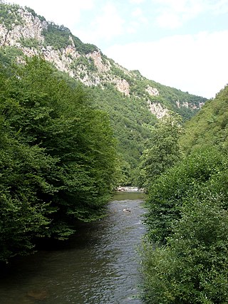
Hajla is a mountain located between the borders of Kosovo and Montenegro. It has several peaks that reach over 2,000 m (6,562 ft), the highest having 2,403 m (7,884 ft) which is also called Hajla. The northern slopes contains the spring formation of the Ibar river, and to its southern slopes is the origin of the Bistrica e Pejës river. Hajla is also the highest mountain in the northern part of the Accursed Mountains of the Balkans. In Kosovo, Hajla forms part of the 25 km (16 mi) long Rugova Canyon. The nearest city to Hajla is Rožaje, in Montenegro.
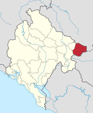
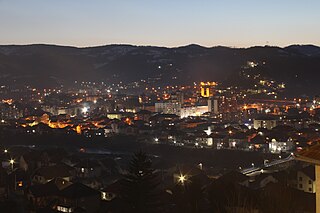
Rožaje Municipality is one of the municipalities of Montenegro. The main centre and capital of the Rožaje municipality is Rožaje. It covers an area of 432 km2, and has a population of 22,964 inhabitants in the 2011 Census. It is located in northern Montenegro.

Lake Rujište is a lake located in Biševo, a local center in Rožaje, Montenegro. The potentials of this lake are still not fully realized. This lake is one of the most visited natural locations in Rožaje. Next to the lake is an alp called Gospođin Vrh. The area where this lake is located is called Rujišta and for the future it has planned for a golf course with suitable facilities.

Mitrovica District is one of the seven districts of Kosovo. Its administrative center and the largest city is Mitrovica. The district borders on the District of Peja to the south-west, the District of Pristina to the south and east, and the Serbia to the north and northwest.
