
Aust-Agder was one 18 counties (fylker) in Norway up to 1 January 2020, when it was merged with Vest-Agder to form Agder county. In 2002, there were 102,945 inhabitants, which was 2.2% of Norway's population. Its area was 9,212 square kilometres (3,557 sq mi). The county's administrative center was the town of Arendal.

Arendal is a municipality in Agder county in southeastern Norway. Arendal belongs to the region of Sørlandet. The administrative centre of the municipality is the city of Arendal. Some of the notable villages in Arendal include Rykene, Eydehavn, Færvik, Strengereid, Kongshavn, Kilsund, Brattekleiv, Torsbudalen, Longum, Saltrød, Staubø, Vrengen, and Kolbjørnsvik. The offices of UNEP/GRID-Arendal are also located in the city of Arendal.

Fevik is a village in Grimstad municipality in Agder county, Norway. The village is located along the Skaggerak coast about 7 kilometres (4.3 mi) northeast of the town of Grimstad and about 15 kilometres (9.3 mi) south of the city of Arendal. The village of Vik lies just southwest of Fevik.

Rykene or Rygene is a village located along the river Nidelva in Agder county, Norway. The village is primarily located in Arendal municipality, but a small portion of the village lies across the river in the neighboring municipality of Grimstad. Rykene is located about 10 kilometres (6.2 mi) north of the town of Grimstad and about the same distance south of the city of Arendal. Historically, the village grew up due to its close proximity to forests as the timber was floated down river to the sawmills in Rykene. The village of Lindtveit lies about 2 kilometres (1.2 mi) to the northwest, the village of Løddesøl lies about 4 kilometres (2.5 mi) to the north, the village of Gjennestad lies about 3 kilometres (1.9 mi) to the northeast. The village sits at the junction of Norwegian County Road 407 and Norwegian County Road 408.

Kilsund is a village in Arendal municipality in Agder county, Norway. The village is located on the island of Tverrdalsøya, although the village has grown over the bridge onto the nearby island of Flostaøya a short distance to the south. The village lies about 6.5 kilometres (4.0 mi) northeast of the village of Strengereid, about 10 kilometres (6.2 mi) northeast of the village of Eydehavn, about 16 kilometres (9.9 mi) northeast of the town of Arendal, and about 8 kilometres (5.0 mi) south of the town of Tvedestrand. Kilsund has two small villages located just to the north and east: Staubø and Holmsund.

Strengereid is a village in the municipality of Arendal in Agder county, Norway. It is located along the Norwegian County Road 410, about 3 kilometres (1.9 mi) northeast of the village of Eydehavn and just west of the island of Flostaøya. The village of Sagene lies about 2 kilometres (1.2 mi) to the northwest.

Øyestad is a former municipality in Aust-Agder county, Norway. The municipality existed from 1838 until 1992 when it was merged into the present-day municipality of Arendal. At the time of its dissolution, the 96-square-kilometre (37 sq mi) municipality of Øyestad encompassed most of the coastline between the towns of Grimstad and Arendal, along with the forested areas along the Nidelva river heading inland. Back in 1838, however, the municipality was far larger in size. The administrative centre was the village of Bjorbekk near the Bjorbekk Church.

Norwegian county road 407 is a Norwegian county road in Agder county, Norway. The 13.9-kilometre (8.6 mi) highway runs between the village of Vik in Grimstad municipality and Sponvika on the south side of the city of Arendal in Arendal municipality. Prior to the transportation reforms of 2010, this road was a Norwegian national road, but since then it was taken over by the county.
Asdal is a village in Arendal municipality in Agder county, Norway. The village is located along Norwegian County Road 407 between the European route E18 highway and the river Nidelva. The village sits between the village of Fevik to the south and the town of Arendal to the northeast. The village of Vrengen lies immediately north of Asdal and the village of Rød lies across the river to the southeast.

Bjorbekk is a village in Arendal municipality in Agder county, Norway. The village is located between the Norwegian County Road 407 and the European route E18 highway. The village of Vrengen lies just east of Bjorbekk and the village of Asdal lies just to the south. Bjorbekk Church is located in the village.

Brattekleiv is a village in Arendal municipality in Agder county, Norway. The village is located along the Galtesundet strait on the southwestern shore of the island of Tromøy. The village lies about 1 kilometre (0.62 mi) southwest of the town of Arendal which is located across the strait. The smaller industrial village of Pusnes lies immediately north of Brattekleiv, the small village of Revesand lies just south of the village, and the village of Færvik lies a short distance to the east.

Narestø is a village in Arendal municipality in Agder county, Norway. The village is located on the southern shore of the island of Flostaøya, just south of the historic Flosta Church. The village of Kalvøysund lies about 3 kilometres (1.9 mi) to the northeast.
Nedenes is a village in Arendal municipality in Agder county, Norway. The village is located in the southern part of Arendal, just north of the municipal border with Grimstad. The Norwegian County Road 420 runs through the village heading north to the village of Rød and onwards to the island of Hisøya to the north. Engene Church is located in Nedenes.
Rød or Røed is a village in Arendal municipality in Agder county, Norway. The village is located at the mouth of the river Nidelva on the southwest side of the river, across the river from the villages of Asdal and Vrengen. The village lies along the Norwegian County Road 420, which leads north to the village of His on the island of Hisøya to the north, and the road leads south to the village of Nedenes and onwards to the municipality of Grimstad.
Sagene is a village in Arendal municipality in Agder county, Norway. The village is located about 2 kilometres (1.2 mi) northwest of the village of Strengereid in the Moland area of Arendal. The lake Langangsvannet lies just east of the village.
Stoa is an industrial village in Arendal municipality in Agder county, Norway. The village is located along the European route E18 highway and along the Arendalsbanen railway line. It sits about 3 kilometres (1.9 mi) west of the centre of the town of Arendal. The villages of Bjorbekk and Vrengen lie a short distance to the south.
Åmdalsøyra or Omdalsøyra is a village in Arendal municipality in Agder county, Norway, along the Tromøysundet strait on the northern shore of the island of Tromøy. The village of Kongshavn lies just to the southwest of Åmdalsøyra, and the village of Eydehavn lies just across the strait on the mainland.
Arendal is a city in Agder county, Norway. The city is the administrative centre of the municipality of Arendal and the seat of the County governor of Aust-Agder. The city also includes some area in the neighboring municipality of Grimstad as well. In Norway, Arendal is considered a by which can be translated as either a "town" or "city" in English.
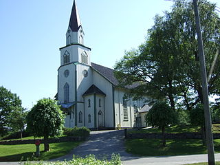
Bjorbekk Church is a parish church in Arendal municipality in Agder county, Norway. It is located in the village of Bjorbekk. It is the church for the Øyestad parish which is part of the Arendal prosti (deanery) in the Diocese of Agder og Telemark.


