
Torell Land is a land area at the southeast part of Spitsbergen, Svalbard. It is named after Otto Martin Torell. Two glaciers, Hornbreen and Hambergbreen, divide Torell Land from Sørkapp Land.
Tjuvfjordlaguna is a lagoon at Edgeøya, Svalbard. It is located just inside the head of Tjuvfjorden, at the southeast side of the valley Dyrdalen, and northwest of Schneiderberget. The glacier Deltabreen debouches into the lagoon.
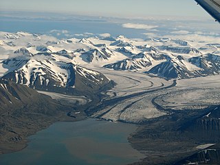
Recherchebreen is a glacier in Wedel Jarlsberg Land at Spitsbergen, Svalbard. The glacier has a length of about 16 kilometers (9.9 mi). It is located in a valley between Martinfjella and Observatoriefjellet, and debouches into Recherche Fjord. Among its tributary glaciers are Foldnutfonna, Varderyggfonna, Dollfusbreen, Ramondbreen and Bjørnbreen.

Markhambreen is a glacier in Torell Land at Spitsbergen, Svalbard. It is named after English geographer Clements Robert Markham.
Fagerstafjella is a mountain group in Nathorst Land at Spitsbergen, Svalbard. The group is located south of Van Mijenfjorden, between Scheelebreen and Danzigdalen. The highest mountain in the group is Aspelintoppen, which is also the highest mountain in Nathorst Land.
Aldegondabreen is a glacier in Nordenskiöld Land at Spitsbergen, Svalbard, Norway. It is named after Infanta Adelgundes, Duchess of Guimarães. The glacier has a length of about 5.5 kilometers. It flows from Qvigstadfjellet, Christensenfjella and Hermod Petersenfjellet towards Grønfjorden.
Lågnesflya is a coastal plain in Nordenskiöld Land at Spitsbergen, Svalbard. It is located between the lakes of Femvatna and Andungen in the north and Ytterdalselva in the southeast, the bays of Van Muydenbukta and Marvågen, and the hills of Lågnesrabbane. The pyramid shaped landmark of Ytterdalsgubben is located between Lågnesflya and the glacier of Erdmannbreen.
Løyndbreen is a glacier in Nathorst Land at Spitsbergen, Svalbard. It has a length of about four kilometers, situated between the mountains of Bassøefjellet and Langlifjellet, and extending towards the valley of Bromelldalen.
Linnébreen is a glacier in Nordenskiöld Land at Spitsbergen, Svalbard, Norway. It is named after Swedish botanist Carl Linnaeus. The glacier has a length of about 3.5 kilometers, and flows from the mountain of Systemafjellet towards the valley of Linnédalen. It is proximate to the mountain of Christensenfjella.
Svalisbreen is a glacier in Sørkapp Land at Spitsbergen, Svalbard. It has a length of about 12.5 kilometers, extending from the mountain pass of Svanhildpasset to Hornbreen, towards the bay of Brepollen, the inner part of Hornsund.

Storbreen is a glacier in Torell Land at Spitsbergen, Svalbard. It has a length of about fifteen kilometers, and debouches towards the bay of Brepollen, the inner part of Hornsund.
Hedgehogfonna is a glacier field in Sørkapp Land at Spitsbergen, Svalbard. It is located west of the mountain of Hedgehogfjellet, and is separated from the glacier of Vasil'evbreen by Skilfonna.
Sykorabreen is a glacier in Sørkapp Land at Spitsbergen, Svalbard. It has a length of about seven kilometers, and extends northwards from Hedgehogfonna to Hambergbreen. The glacier is named after Russian scientist J. Sykora, who participated with the Swedish-Russian Arc-of-Meridian Expedition 1899–1900.

Scheelebreen is a glacier in Nathorst Land at Spitsbergen, Svalbard. It has a length of about sixteen kilometers, and is located between the mountains of Vriompeisen and Fagerstafjella. The glacier is named after Swedish chemist Carl Wilhelm Scheele.
Paulabreen is a glacier in Nathorst Land and Heer Land at Spitsbergen, Svalbard. It has a length of about fifteen kilometers, extending from the mountain of Kjølberget to the bay of Rindersbukta. The glacier is named after Paula, the wife of shipmaster Richard Ritter von Barry. Paulabreen borders to the mountain area of Vriompeisen, and the mountain of Hollertoppen. A tributary glacier is Bakaninbreen.
Bakaninbreen is a glacier in Heer Land at Spitsbergen, Svalbard. It has a length of about 9.5 kilometers, and merges with the glacier of Paulabreen. The glacier is named after a member of the Swedish-Russian Arc-of-Meridian Expedition. The mountain of Hollertoppen is located between Bakaninbreen and Ragna-Mariebreen.
Hollertoppen is a mountain in Heer Land at Spitsbergen, Svalbard. It has a height of 1,012 m.a.s.l., and is located between the glaciers of Bakaninbreen and Ragna-Mariebreen, north of Paulabreen. The mountain is named after Norwegian Minister of Industry Kjell Holler.
Rindersbukta is a bay in Nathorst Land and Heer Land at Spitsbergen, Svalbard. It forms the southern branch of Van Mijenfjorden. The glaciers of Scheelebreen and Paulabreen debouche into the bay. The bay is named after Dutch whaler Michiel Rinders.
Steindolpbreen is a glacier in Nathorst Land at Spitsbergen, Svalbard. It extends from Juvtinden and the eastern side of Steindolptoppen to Snøkuvbreen. North of the glacier are the mountains of Rånekampen and Vengefjellet.
Scottbreen is a glacier in Wedel Jarlsberg Land at Spitsbergen, Svalbard. The glacier has a length of about 4.5 kilometers. It is located between Wijkanderberget and the ridge of Bohlinryggen, which separates Scottbreen from the glacier of Renardbreen.
