
Štefanovce is a village and municipality in Vranov nad Topľou District in the Prešov Region of eastern Slovakia.

Dobroszyce is a village in Oleśnica County, Lower Silesian Voivodeship, in south-western Poland. It is the seat of the administrative district (gmina) called Gmina Dobroszyce. It was in Germany until 1945.
The canton of Forcalquier is an administrative division in southeastern France. At the French canton reorganisation which came into effect in March 2015, the canton was expanded from 10 to 15 communes:

Ikuno Station is a railway station in Engaru, Monbetsu, Hokkaido Prefecture, Japan. Its station number is A52.

Dmochy-Mrozy is a village in the administrative district of Gmina Czyżew-Osada, within Wysokie Mazowieckie County, Podlaskie Voivodeship, in north-eastern Poland. It lies approximately 6 kilometres (4 mi) north-west of Czyżew-Osada, 20 km (12 mi) south-west of Wysokie Mazowieckie, and 69 km (43 mi) south-west of the regional capital Białystok.
Kłoczew is a village in Ryki County, Lublin Voivodeship, in eastern Poland. It is the seat of the gmina called Gmina Kłoczew. It lies approximately 11 kilometres (7 mi) north of Ryki and 68 km (42 mi) north-west of the regional capital Lublin.
Kałków is a village in the administrative district of Gmina Pawłów, within Starachowice County, Świętokrzyskie Voivodeship, in south-central Poland. It lies approximately 5 kilometres (3 mi) east of Pawłów, 13 km (8 mi) south-east of Starachowice, and 40 km (25 mi) east of the regional capital Kielce.
Karolów is a village in the administrative district of Gmina Chotcza, within Lipsko County, Masovian Voivodeship, in east-central Poland.
Budziska is a village in the administrative district of Gmina Mrągowo, within Mrągowo County, Warmian-Masurian Voivodeship, in northern Poland. It lies approximately 14 kilometres (9 mi) north-east of Mrągowo and 64 km (40 mi) east of the regional capital Olsztyn.
Łąck Mały is a settlement in the administrative district of Gmina Świętajno, within Szczytno County, Warmian-Masurian Voivodeship, in northern Poland.
Koźlak is a village in the administrative district of Gmina Budry, within Węgorzewo County, Warmian-Masurian Voivodeship, in northern Poland, close to the border with the Kaliningrad Oblast of Russia.
Pleasant Corners, New York is a hamlet in the town of Wilson in Niagara County, New York, United States.

Gornja Stražava is a village in the municipality of Prokuplje, Serbia. According to the 2002 census, the village has a population of 768 people.
Boljevac Selo is a village in the municipality of Boljevac, Serbia. According to the 2002 census, the village had a population of 315 people.
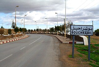
Bouchrahil is a town and commune in Médéa Province, Algeria. According to the 1998 census it has a population of 18,308.
Tovarište is a village in the municipality of Fojnica, Bosnia and Herzegovina.
Vilić Polje is a village in the municipality of Gornji Vakuf, Bosnia and Herzegovina.

Donja Brštanica is a village in the municipality of Višegrad, Bosnia and Herzegovina.

Ashworth Glacier is an Antarctic glacier with sharply delineated sides, flowing west from Supporters Range into Mill Glacier, 5 kilometres (3 mi) north of Mount Iveagh. It was named by the Advisory Committee on Antarctic Names in 2007, after Allan C. Ashworth, Professor of Paleontology and Stratigraphy at North Dakota State University. He discovered the only yet known fly and beetle fossils in Antarctica in the nearby Dominion Range.
Loboder is a village in the municipality of Trstenik, Serbia. According to the 2002 census, the village has a population of 53 people.


