
The Iron Gates is a gorge on the river Danube. It forms part of the boundary between Serbia and Romania (north). In the broad sense it encompasses a route of 134 km (83 mi); in the narrow sense it only encompasses the last barrier on this route, just beyond the Romanian city of Orșova, that contains two hydroelectric dams, with two power stations, Iron Gate I Hydroelectric Power Station and Iron Gate II Hydroelectric Power Station.
Fodor's is a publisher of English language travel and tourism information and the first relatively professional producer of travel guidebooks. Fodor's Travel and Fodors.com are divisions of Internet Brands.

The Barada is the main river of Damascus, the capital city of Syria.
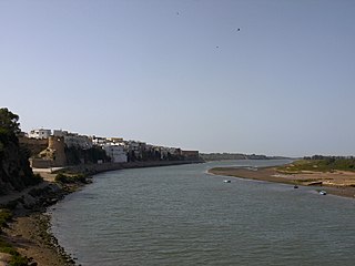
Azemmour or Azamor is a Moroccan city, lying at the Atlantic ocean coast, on the left bank of the Oum Er-Rbia River, 75 km southwest of Casablanca.

Papri chaat, paapri chaat or papdi chaat is a popular traditional fast food and street food from the Indian subcontinent, notably in North India, Bangladesh and Pakistan. Many various additional dishes throughout India are also referred to as papri chaat. Some restaurants in the United States serve the traditional version of the dish.

The Turkwel River is a river flowing from Mount Elgon in the border of Kenya and Uganda to Lake Turkana. The river is called the Suam River from its source to the border with the West Pokot County of Kenya. The name Turkwel is derived from the Turkana name for the river, Tir-kol, which means translates to a river that "withstands the wilderness". The Turkwel begins from the lush green slopes of Mount Elgon and the Cherangani Hills, traverses the Southern Turkana Plains, crosses Loturerei Desert near Lodwar and empties to the world's largest desert lake, Lake Turkana. The river's flow is seasonally varied, and it is subject to flash floods in the rainy season.

Mylopotamos is a village on the island of Cythera, southern Greece. It was named Mylopotamos because there are 22 watermills built along a small stream. The water mills were built for grinding wheat. Today 21 of the mills are in ruins and one, the Phil's (Φιλιππή'ς) water mill, is in working condition. Phil's watermill belongs to the grandson of the last owner, Filippas (Φίλιππας), and it has been in the family for 350 years.
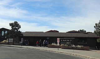
Maswik Lodge is a lodge in Grand Canyon National Park that is run by Xanterra Parks & Resorts. It is named after a Hopi Kachina figure said to watch over the Grand Canyon. Maswik Lodge is located about 0.25 miles (0.40 km) from the South Rim of the Grand Canyon. It is on the west side of Grand Canyon Village. The lodge contains a cafeteria, lounge, and many spread out room complexes.

Kuragano-shuku was the twelfth of the sixty-nine stations of the Nakasendō. It is located in the present-day city of Takasaki, Gunma Prefecture, Japan.

Hopewell Centre or QRE Plaza is a 25-storey building located at No. 202 Queen's Road East, Wan Chai, Hong Kong, developed by Hopewell Holdings. The plaza was completed in 2007 and contains a shopping centre, restaurants and health clinics. QRE Plaza measures nearly 89 metres (292 ft) in height, and has a Gross floor area (GFA) of about 77,000 square feet (7,200 m2).
Maricao State Forest is located on the island of Puerto Rico, spread through the towns of San Germán, Sabana Grande and Maricao. It is commonly known as only the Monte del Estado.

Greece is a country in Southern Europe, bordered to the north by Albania, North Macedonia and Bulgaria; to the east by Turkey, and is surrounded to the east by the Aegean Sea, to the south by the Cretan and the Libyan Seas, and to the west by the Ionian Sea which separates Greece from Italy.
Daedala or Daidala was a city of the Rhodian Peraea in ancient Caria, or a small place, as Stephanus of Byzantium says, on the authority of Strabo.

Estremadura Province is one of the six historical provinces of Portugal. It is located along the Atlantic Ocean coast in the center of the country and includes Lisbon, the capital. The name of this province originates from the Spanish and Portuguese struggle with the Moors, and the Christian reclaiming of their land in the 12th century. These provinces were called Extrema Durii, which means "farthest from the Douro River."

The New Fortress of Corfu is a Venetian fortress built on the hill of St. Mark in Corfu in stages. The original architect of the fort was the military engineer Ferrante Vitelli. The current buildings which exist within the fortress were built by the British during their rule of the island (1815–63).
Bobcat Pass is a mountain pass located in Taos County, New Mexico on the Enchanted Circle Scenic Byway.

The Three Gorges Museum is a museum in the Yuzhong District of Chongqing, about the Three Gorges and Chongqing. It is one of the largest museum of the country.
Batdorf & Bronson is an Olympia, Washington based coffee roaster established in 1986. Described by Lonely Planet as "Olympia's most famous coffee", and by Fodor's as "a local roaster that can stand up to the best of Seattle". The roastery operations are next door to the Olympia Farmer's Market in downtown Olympia.


