
Rødøy is a municipality in Nordland county, Norway. It is part of the Helgeland traditional region. The administrative centre of the municipality is the village of Vågaholmen. Other villages include Gjerøy, Jektvika, Kilboghamn, Melfjordbotn, Oldervika, Sørfjorden, and Tjong. The municipality consists of many islands to the west of Norway's second biggest glacier, Svartisen.

Meløy is a municipality in Nordland county, Norway. It is part of the Salten traditional region. The administrative centre of the municipality is the village of Ørnes. Other villages include Eidbukt, Neverdal, Glomfjord, Halsa, Reipå, Støtt, and Ågskardet.

Saltfjellet–Svartisen National Park is a national park in Nordland county in Norway. It is located within the municipalities of Beiarn, Meløy, Rana, Rødøy, Saltdal, and Bodø. The European route E6 highway and the Nordland Line railway both follow the southern and eastern borders around the park. The park's eastern border is the Norway-Sweden border and a portion of this border is shared with the Vindelfjällen Nature Reserve which lies in Sweden.
Gjerdøya is an island in Rødøy Municipality in Nordland county, Norway. It is located in a group of islands located west of the peninsula between the Tjongsfjorden and Melfjorden. It lies south of the island of Rødøya, north of the island of Rangsundøya, and west of the island of Renga. The main village on the island is called Gjerøy. The 9.3-square-kilometre (3.6 sq mi) island has a population (2016) of 87 people. There is regular ferry service to Gjerdøya from the mainland and to the islands surrounding it.
Oldervik may refer to the following locations:
Oldervika may refer to the following locations:
Oldervika is a village in Rødøy Municipality in Nordland county, Norway. The village is located on the eastern shore of the Sørfjorden, just north of the village of Sørfjorden. Although it is located on the mainland, there are no road connections to the rest of Norway. It has a ferry connection to Kilboghamn to the west and Jektvika to the north.

Saltfjellet is a mountain area in Nordland county, Norway that separates the two regions of Helgeland and Salten. It is also a cultural border between the Southern and Central parts of Sápmi.
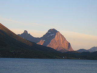
Blokktinden is a mountain in Rødøy Municipality in Nordland county, Norway. It is located on the southern side of Tjongsfjorden, across from the village of Tjong. The summit has a good view of the Svartisen glacier and the coastal islands.
Ågskardet is a village in Meløy Municipality in Nordland county, Norway. It is located on the southern side of the Holandsfjorden, about 3.5 kilometres (2.2 mi) north of the village of Tjong. There were 127 inhabitants in 2008.

Storselsøya is an island in Nordland county, Norway. The island is divided between two municipalities: Rødøy Municipality in the north and Lurøy Municipality in the south. The island of Nesøya lies to the west, the island of Lurøya lies to the south, and the mainland village of Tonnes lies to the east.

Rødøya is an island in Rødøy Municipality in Nordland county, Norway. The 8.5-square-kilometre (3.3 sq mi) island is located just west of the mouth of the Tjongsfjorden, north of the island of Gjerdøya, and west of the mainland. There are ferry connections from the village of Rødøy to the village of Jektvika on the mainland and to the nearby island of Gjerdøya. Rødøy Church is located in the village of Rødøy on the south side of the island. The island had 150 residents in 2017.
Tjongsfjorden is a fjord in Rødøy Municipality in Nordland county, Norway. The 17-kilometre (11 mi) long fjord begins just west of the Svartisen glacier; it flows west and flows into the Rødøyfjorden, which is just east of the island of Rødøya. The mountain, Blokktinden, lies on the southern shore. The village, Tjong and Vågaholmen, lie along the northern shore. Norwegian County Road 17, running across Nordland and Trøndelag counties, runs along the inner part of the fjord.

Melfjorden is a fjord in Rødøy Municipality in Nordland county, Norway. It is located on the Arctic Circle. The 33-kilometre (21 mi) long fjord goes from the village of Melfjordbotn in the east to its mouth in the Rødøyfjorden near the island of Rangsundøya. There are two fjord arms that branch off the main fjord: Nordfjorden flows to the north into the Saltfjellet–Svartisen National Park and Sørfjorden to the south past the villages of Sørfjorden and Kilboghavn.
Melfjordbotn or Melfjorden is a village in Rødøy Municipality in Nordland county, Norway. The village is located at the eastern end of the Melfjorden, southwest of the Svartisen glacier. The Saltfjellet–Svartisen National Park lies about 7 kilometres (4.3 mi) north of the village.

Rødøy Church is a parish church of the Church of Norway in Rødøy Municipality in Nordland county, Norway. It is located on the island of Rødøya. It is one of the churches in the Rødøy parish which is part of the Nord-Helgeland prosti (deanery) in the Diocese of Sør-Hålogaland. The white, wooden church was built in an octagonal style in 1885 using plans drawn up by the architect Andreas Grenstad. The church seats about 700 people.
Tjongsfjorden Church is a parish church of the Church of Norway in Rødøy Municipality in Nordland county, Norway. It is located in the village of Tjong on the mainland in the northern part of the municipality. It is one of the churches in the Rødøy parish which is part of the Nord-Helgeland prosti (deanery) in the Diocese of Sør-Hålogaland. The white, wooden church was built in a long church style in 1962 using plans drawn up by the architect Per Myrvold. The church seats about 280 people.
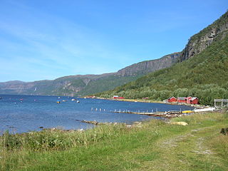
Sørfjorden Church is a parish church of the Church of Norway in Rødøy Municipality in Nordland county, Norway. It is located in the village of Sørfjorden on the mainland in the southern part of the municipality. It is one of the churches in the Rødøy parish which is part of the Nord-Helgeland prosti (deanery) in the Diocese of Sør-Hålogaland. The white, wooden church was built in a long church style in 1916 using plans drawn up by the architect O.M. Olsen. The church seats about 130 people.
Tjong is a village in Rødøy Municipality in Nordland county, Norway. The village is located along the Tjongsfjorden, east of the municipal center of Vågaholmen. The local church, Tjongsfjorden Church, serves all of northeastern Rødøy. The village of Ågskardet in neighboring Meløy Municipality lies about 3.5 kilometres (2.2 mi) to the north.


