
Jäkärlä is a district in the Maaria-Paattinen ward of the city of Turku, in Finland. It is located to the north of the city, and is a very sparsely populated area.
Sobczyce is a village in the administrative district of Gmina Kotla, within Głogów County, Lower Silesian Voivodeship, in southwestern Poland. Prior to 1945 it was in Germany.
Mikorzyce is a village in the administrative district of Gmina Wołów, within Wołów County, Lower Silesian Voivodeship, in south-western Poland. Prior to 1945 it was in Germany.

Ośno Drugie is a village in the administrative district of Gmina Aleksandrów Kujawski, within Aleksandrów County, Kuyavian-Pomeranian Voivodeship, in north-central Poland. It lies 3 kilometres (2 mi) south of Aleksandrów Kujawski and 22 km (14 mi) south of Toruń.

Dobków is a village in the administrative district of Gmina Wodzierady, within Łask County, Łódź Voivodeship, in central Poland. It lies approximately 3 kilometres (2 mi) south-west of Wodzierady, 14 km (9 mi) north of Łask, and 26 km (16 mi) west of the regional capital Łódź.
Adamów is a village in the administrative district of Gmina Opoczno, within Opoczno County, Łódź Voivodeship, in central Poland.
Glina is a village in the administrative district of Gmina Wola Krzysztoporska, within Piotrków County, Łódź Voivodeship, in central Poland. It lies approximately 7 kilometres (4 mi) east of Wola Krzysztoporska, 5 km (3 mi) south of Piotrków Trybunalski, and 49 km (30 mi) south of the regional capital Łódź.
Kamienna-Kolonia is a village in the administrative district of Gmina Błaszki, within Sieradz County, Łódź Voivodeship, in central Poland. It lies approximately 6 kilometres (4 mi) west of Błaszki, 28 km (17 mi) west of Sieradz, and 78 km (48 mi) west of the regional capital Łódź.
Czarna is a village in the administrative district of Gmina Pierzchnica, within Kielce County, Świętokrzyskie Voivodeship, in south-central Poland. It lies approximately 8 kilometres (5 mi) east of Pierzchnica and 27 km (17 mi) south-east of the regional capital Kielce.
Dzierzgów is a village in the administrative district of Gmina Radków, within Włoszczowa County, Świętokrzyskie Voivodeship, in south-central Poland. It lies approximately 3 kilometres (2 mi) south-west of Radków, 17 km (11 mi) south of Włoszczowa, and 51 km (32 mi) south-west of the regional capital Kielce.
Grzybów is a village in the administrative district of Gmina Magnuszew, within Kozienice County, Masovian Voivodeship, in east-central Poland. It lies approximately 3 kilometres (2 mi) north-west of Magnuszew, 26 km (16 mi) north-west of Kozienice, and 55 km (34 mi) south-east of Warsaw.
Podsmardzewo is a village in the administrative district of Gmina Sochocin, within Płońsk County, Masovian Voivodeship, in east-central Poland.
Krzyżowiec is a village in the administrative district of Gmina Włoszakowice, within Leszno County, Greater Poland Voivodeship, in west-central Poland. It lies approximately 5 kilometres (3 mi) south of Włoszakowice, 16 km (10 mi) west of Leszno, and 68 km (42 mi) south-west of the regional capital Poznań.
Kuźnica Kącka is a village in the administrative district of Gmina Sośnie, within Ostrów Wielkopolski County, Greater Poland Voivodeship, in west-central Poland.
Żerdziny is a village in the administrative district of Gmina Dubeninki, within Gołdap County, Warmian-Masurian Voivodeship, in northern Poland, close to the border with the Kaliningrad Oblast of Russia. It lies approximately 17 kilometres (11 mi) north-east of Dubeninki, 32 km (20 mi) east of Gołdap, and 163 km (101 mi) north-east of the regional capital Olsztyn.
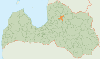
Priekuļi Municipality is a municipality in Vidzeme, Latvia. The municipality was formed in 2009 by merging Liepa parish, Mārsnēni parish, Priekuļi parish and Veselava parish the administrative centre being Priekuļi.
Banibangou is a village and rural commune in Niger. It was the site of attacks on Fula pastoralists by Zarma people in December 2008, resulting in the rustling of over 20,000 cattle and the deaths of approximately 235 Fulas.
Emdjez Edchich is a town and commune in Skikda Province in north-eastern Algeria.

Citizen Plaza Station, also known as Shiminguangchang Station, is a station of Line 9 of the Tianjin Metro. It started operations on 28 March 2004.
Göktaş Dam Turkish: Göktaş Barajı) is a hydroelectric plant in Turkey.


