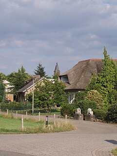
Molenhoek is a village with a population of 3,600 located in south-eastern Netherlands partially in the municipality of Mook en Middelaar in the province of Limburg and partially in the municipality of Heumen in the province of Gelderland. It is also the northern-most town of Limburg and thus its nickname is "De Poort van Limburg".
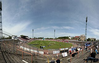
The Kurt-Wabbel-Stadion was a multi-purpose stadium in Halle (Saale), Germany. It was used mostly for football matches, was the home of Hallescher FC, and had a capacity of 23,860. It was replaced by Erdgas Sportpark in 2010.
Bethany is a neighborhood of Louisville, Kentucky located on Dixie Highway by Bethany Cemetery.
Kruisstraat is a hamlet in the Dutch province of North Brabant. It is located in the municipality of Roosendaal, about 3 km southwest of the city centre.

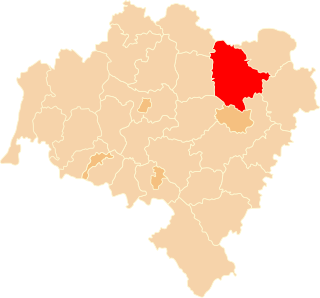
Małuszów is a village in the administrative district of Gmina Kobierzyce, within Wrocław County, Lower Silesian Voivodeship, in south-western Poland. Prior to 1945 it was in Germany. It lies approximately 6 kilometres (4 mi) north-west of Kobierzyce and 18 km (11 mi) south-west of the regional capital Wrocław.

Seyidlar is a village in the Lachin Rayon of Azerbaijan.
Swolszewice Duże is a village in the administrative district of Gmina Wolbórz, within Piotrków County, Łódź Voivodeship, in central Poland.

Żarnowica Duża is a village in the administrative district of Gmina Wolbórz, within Piotrków County, Łódź Voivodeship, in central Poland. It lies approximately 5 kilometres (3 mi) south of Wolbórz, 14 km (9 mi) north-east of Piotrków Trybunalski, and 44 km (27 mi) south-east of the regional capital Łódź.
Kijanice is a village in the administrative district of Gmina Lututów, within Wieruszów County, Łódź Voivodeship, in central Poland. It lies approximately 3 kilometres (2 mi) east of Lututów, 24 km (15 mi) east of Wieruszów, and 84 km (52 mi) south-west of the regional capital Łódź.
Zaświatycze is a village in the administrative district of Gmina Hanna, within Włodawa County, Lublin Voivodeship, in eastern Poland, close to the border with Belarus.
Jadwigów is a village in the administrative district of Gmina Promna, within Białobrzegi County, Masovian Voivodeship, in east-central Poland.
Lipie is a village in the administrative district of Gmina Piaski, within Gostyń County, Greater Poland Voivodeship, in west-central Poland. It lies approximately 4 kilometres (2 mi) east of Piaski, 8 km (5 mi) east of Gostyń, and 61 km (38 mi) south of the regional capital Poznań.
Buszkowo-Parcele is a village in the administrative district of Gmina Skulsk, within Konin County, Greater Poland Voivodeship, in west-central Poland.
Ostrówek is a village in the administrative district of Gmina Wierzbinek, within Konin County, Greater Poland Voivodeship, in west-central Poland.
Klon is a village in the administrative district of Gmina Czajków, within Ostrzeszów County, Greater Poland Voivodeship, in west-central Poland. It lies approximately 22 kilometres (14 mi) east of Ostrzeszów and 141 km (88 mi) south-east of the regional capital Poznań.
Tuczenko is a settlement in the administrative district of Gmina Strzelce Krajeńskie, within Strzelce-Drezdenko County, Lubusz Voivodeship, in western Poland. It lies approximately 14 kilometres (9 mi) north of Strzelce Krajeńskie and 32 km (20 mi) north-east of Gorzów Wielkopolski.
Ratajki is a village in the administrative district of Gmina Sianów, within Koszalin County, West Pomeranian Voivodeship, in north-western Poland. It lies approximately 12 kilometres (7 mi) east of Sianów, 19 km (12 mi) east of Koszalin, and 152 km (94 mi) north-east of the regional capital Szczecin.
Kanin is a village in the administrative district of Gmina Postomino, within Sławno County, West Pomeranian Voivodeship, in north-western Poland. It lies approximately 9 kilometres (6 mi) west of Postomino, 13 km (8 mi) north-west of Sławno, and 176 km (109 mi) north-east of the regional capital Szczecin.
Radusz is a village in the administrative district of Gmina Grzmiąca, within Szczecinek County, West Pomeranian Voivodeship, in north-western Poland.
Erdgas Sportpark, is a stadium in Halle, Germany. It has a capacity of 15,057 spectators. It is the home of Hallescher FC and replaced Kurt-Wabbel-Stadion.