The Euphrates is the longest and one of the most historically important rivers of Western Asia. Together with the Tigris, it is one of the two defining rivers of Mesopotamia. Originating in the Armenian Highlands, the Euphrates flows through Syria and Iraq to join the Tigris in the Shatt al-Arab, which empties into the Persian Gulf.

A dam is a barrier that stops or restricts the flow of water or underground streams. Reservoirs created by dams not only suppress floods but also provide water for activities such as irrigation, human consumption, industrial use, aquaculture, and navigability. Hydropower is often used in conjunction with dams to generate electricity. A dam can also be used to collect water or for storage of water which can be evenly distributed between locations. Dams generally serve the primary purpose of retaining water, while other structures such as floodgates or levees are used to manage or prevent water flow into specific land regions. The earliest known dam is the Jawa Dam in Jordan, dating to 3,000 BC.

The Tennessee Valley Authority (TVA) is a federally owned corporation in the United States created by congressional charter on May 18, 1933, to provide navigation, flood control, electricity generation, fertilizer manufacturing, and economic development to the Tennessee Valley, a region particularly affected by the Great Depression. Senator George W. Norris (R-Nebraska) was a strong sponsor of this project. TVA was envisioned not only as a provider, but also as a regional economic development agency that would use federal experts and rural electrification to help modernize the rural region's economy and society.

Al Ain is a city in the Eastern Region of the Emirate of Abu Dhabi, on the United Arab Emirates' border with Oman, adjacent to the town of Al-Buraimi. It is the largest inland city in the Emirates, the fourth-largest overall, and the second-largest in the Emirate of Abu Dhabi. The freeways connecting Al-Ain, Abu Dhabi, and Dubai form a geographic triangle in the country, each city being roughly 130 kilometres (81 mi) from the other two.

Hadhramaut is a region in southern Arabia. The name is of ancient origin, and is retained in the name of the Hadhramaut Governorate of Yemen. The people of Hadhramaut are called Hadhrami. They formerly spoke Hadramautic, but now predominantly speak Hadhrami Arabic.

The United States Bureau of Reclamation (USBR), and formerly the United States Reclamation Service, is a federal agency under the U.S. Department of the Interior, which oversees water resource management, specifically as it applies to the oversight and operation of the diversion, delivery, and storage projects that it has built throughout the western United States for irrigation, water supply, and attendant hydroelectric power generation. Currently the USBR is the largest wholesaler of water in the country, bringing water to more than 31 million people, and providing one in five Western farmers with irrigation water for 10 million acres of farmland, which produce 60% of the nation's vegetables and 25% of its fruits and nuts. The USBR is also the second largest producer of hydroelectric power in the western United States.

The Khabur River is the largest perennial tributary to the Euphrates in Syrian territory. Although the Khabur originates in Turkey, the karstic springs around Ra's al-'Ayn are the river's main source of water. Several important wadis join the Khabur north of Al-Hasakah, together creating what is known as the Khabur Triangle, or Upper Khabur area. From north to south, annual rainfall in the Khabur basin decreases from over 400 mm to less than 200 mm, making the river a vital water source for agriculture throughout history. The Khabur joins the Euphrates near the town of Busayrah.

Wādī Ḥalfā is a city in the Northern state of Sudan on the shores of "Lake Nubia" near the border with Egypt. It is the terminus of a rail line from Khartoum and the point where goods are transferred from rail to ferries going down the lake. As of 2007, the city had a population of 15,725. The town is located amidst numerous ancient Nubian antiquities and was the focus of much archaeological work by teams seeking to save artifacts from the flooding caused by the completion of the Aswan Dam.

The Marib Dam is a dam blocking the Wadi Adhanah in the valley of Dhana in the Balaq Hills, located in the Ma'rib Governorate in Yemen. The current dam was built in the 1980s and is close to the ruins of the Great Dam of Ma'rib built in the 8th century BC. It was one of the engineering wonders of the ancient world and a central part of the Sabaean and Himyarite kingdoms around Ma'rib.
Poverty in Africa is the lack of provision to satisfy the basic human needs of certain people in Africa. African nations typically fall toward the bottom of any list measuring small size economic activity, such as income per capita or GDP per capita, despite a wealth of natural resources. In 2009, 22 of 24 nations identified as having "Low Human Development" on the United Nations' (UN) Human Development Index were in Sub-Saharan Africa. In 2006, 34 of the 50 nations on the UN list of least developed countries were in Africa. In many nations, GDP per capita is less than US$5200 per year, with the vast majority of the population living on much less. In addition, Africa's share of income has been consistently dropping over the past century by any measure. In 1820, the average European worker earned about three times what the average African did. Now, the average European earns twenty times what the average African does. Although GDP per capita incomes in Africa have also been steadily growing, measures are still far better in other parts of the world.

Wadi al-Hasa, known from the Hebrew Bible as the valley and brook of Zered, is a wadi in western Jordan. It is located between the Karak and Tafilah governorates.

Besor is a wadi in southern Israel. The stream begins at Mount Boker, and spills into the Mediterranean Sea near Al-Zahra in the Gaza Strip, where it is called Wadi Ghazzeh, also spelled Wadi Gaza. Further upstream it is marked as Wadi esh-Shallaleh on the 1878 Survey of Western Palestine map. There are several important archaeological sites located in this area.

Hatta is the inland exclave of the emirate of Dubai in the United Arab Emirates.

The wildlife of Egypt is composed of the flora and fauna of this country in northeastern Africa and southwestern Asia, and is substantial and varied. Apart from the fertile Nile Valley, which bisects the country from south to north, the majority of Egypt's landscape is desert, with a few scattered oases. It has long coastlines on the Mediterranean Sea, the Gulf of Suez, the Gulf of Aqaba and the Red Sea. Each geographic region has a diversity of plants and animals each adapted to its own particular habitat.

The Headwater Diversion Plan was an Arab League plan to divert two of the three sources of the Jordan River, and prevent them from flowing into the Sea of Galilee, in order to thwart Israel's plans to use the water of the Hasbani and Banias in its National Water Carrier project for out of Basin irrigation. The plan was approved by the Arab League in 1964 but Israel prevented the project's development by conducting airstrikes in Syrian territory in April 1967.
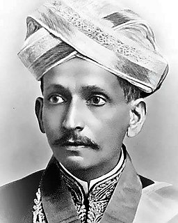
Sir Mokshagundam VisvesvarayaFASc, more commonly known as Sir MV, was an Indian civil engineer and statesman and the 19th Diwan of Mysore, serving from 1912 to 1919. He received India's highest honour, the Bharat Ratna, in 1955. He was knighted as a Knight Commander of the British Indian Empire (KCIE) by King George V for his contributions to the public good. His birthday, 15 September, is celebrated as Engineer's Day in India, Sri Lanka and Tanzania in his memory. He was the Chief Engineer of Krishna Raja Sagara dam in the north-west suburb of Mysuru city, and also served as one of the Chief Engineers of the flood protection system for the city of Hyderabad.
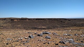
Jawa is the site of the oldest proto-urban development in Jordan, dating from the late 4th millennium BC. It is located in one of the driest areas of the Black Desert of Eastern Jordan.
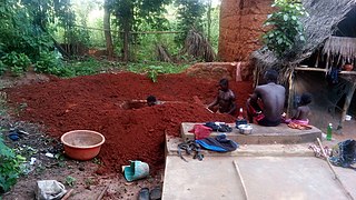
Sudan is a country that is half desert and much of the population suffers from a shortage of clean drinking water as well as a reliable source of water for agriculture. With the Nile river in the east of the country, parts of Sudan have substantial water resources, but those in the west have to rely on wadis, seasonal wells which often dry up. These imbalances in water availability are a source of hardship, as well as a source of conflict. While storage facilities are limited, many local communities have constructed makeshift dams and reservoirs, weirs, which help in stabilizing farming communities. Farmers also utilize hafirs to store rain water which falls in the rainy season, but groundwater remains a vital source of water for over 80% of Sudanese people. For decades, political instability has led to terrible conditions and thwarted many projects and relief efforts, but aid is making its way through. Several water infrastructure projects have been enacted in recent years, with both domestic and international sources of funding. Funding from the UN has provided 9,550 local farmers with better access to water and fertile soils. A project which also plans to replant forest cover in the wadi to reverse desertification.