
Rhineland-Palatinate is a western state of Germany. It covers 19,846 km2 (7,663 sq mi) and has about 4.05 million residents. It is the ninth largest and sixth most populous of the sixteen states. Mainz is the capital and largest city. Other cities are Ludwigshafen am Rhein, Koblenz, Trier, Kaiserslautern and Worms. It is bordered by North Rhine-Westphalia, Saarland, Baden-Württemberg and Hesse and by the countries France, Luxembourg and Belgium.

The Saarland is a state of Germany in the west of the country. With an area of 2,570 km2 (990 sq mi) and population of 995,600 in 2015, it is the smallest German state in area apart from the city-states of Berlin, Bremen, and also Hamburg, and the smallest in population apart from Bremen. Saarbrücken is the state capital and largest city; other cities include Neunkirchen and Saarlouis. Saarland is mainly surrounded by the department of Moselle in France to the west and south and the neighboring state of Rhineland-Palatinate in Germany to the north and east; it also shares a small border about 8 kilometres long with the canton of Remich in Luxembourg to the northwest.

The Nahe is a river in Rhineland-Palatinate and Saarland, Germany, a left tributary to the Rhine. It has also given name to the wine region Nahe situated around it.

The Glan is a river in southwestern Germany, right tributary of the Nahe. It is approximately 68 km long. It rises in the Saarland, northwest of Homburg. It flows generally north, through Rhineland-Palatinate, and empties into the Nahe near Odernheim am Glan, at Staudernheim, across the Nahe from Bad Sobernheim. Other towns along the Glan are Altenglan, Glan-Münchweiler, Lauterecken and Meisenheim.

The Schwarzwälder Hochwald, not to be confused with the High Black Forest, is the high south-western part of the Hunsrück in the German states of Saarland and Rhineland-Palatinate. The mountains are up to 816.32 m high.
The Dollberge are a small mountain range in the northern Saarland and the adjoining part of the state of Rhineland-Palatinate in Germany. They form a southeastern element of the Schwarzwälder Hochwald, a region in the Hunsrück mountains, and are up to 707.4 m above sea level (NN).
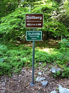
The Dollberg is a mountain in the Dollberge range in central Germany and the highest point in the state of Saarland. It is 695.4 m above sea level (NHN) and lies within the Schwarzwälder Hochwald on the boundary between the counties of Trier-Saarburg (Rhineland-Palatinate) and St. Wendel (Saarland).

Aubach is a river of Rhineland-Palatinate, Germany. It springs southeast of the waste management plant Linkenbach. On its course, it traverses the reservoir Schwanenteich near in borough Oberbieber of Neuwied. It is a left tributary of the Wied in the borough Niederbieber of Neuwied.

Engelsbach is a river of Rhineland-Palatinate, Germany. It springs at the eastern outskirts of Rengsdorf. It flows southward through the valley Engelsbachtal. Near the reservoir Schwanenteich at the suburban administrative district Oberbieber of Neuwied, it discharges into the Aubach from the right.
Langbach is a small river of North Rhine-Westphalia and Rhineland-Palatinate, Germany. It is a right tributary of the Kyll near Frauenkron.
Welzbach is a river of Rhineland-Palatinate, Germany. It is a left tributary of the Rhine near Gau-Algesheim.

Brohlbach is a river of Rhineland-Palatinate, Germany. It is a left tributary of the Rhine at Brohl-Lützing.
Brohlbach is a river of Rhineland-Palatinate, Germany. It is a left tributary of the Moselle at Treis-Karden.

Laubach is a river of Rhineland-Palatinate, Germany. It is a left tributary of the Wied near Melsbach.

Holzbach is a river of Rhineland-Palatinate, Germany. It is a left tributary of the Elbbach in Gemünden.
Spießbach is a river of Rhineland-Palatinate, Germany. It is a left tributary of the Sauer.
Wörsbach is a river of Rhineland-Palatinate, Germany. It is a left tributary of the Odenbach.
Mandelbach is a river of Rhineland-Palatinate, Germany.
Großbach is a river of Rhineland-Palatinate, Germany.
