
The Bay of Islands is an area on the east coast of the Far North District of the North Island of New Zealand. It is one of the most popular fishing, sailing and tourist destinations in the country, and has been renowned internationally for its big-game fishing since American author Zane Grey publicised it in the 1930s. It is 60 km (37 mi) north-west of the city of Whangarei. Cape Reinga, at the northern tip of the country, is about 210 km (130 mi) by road further to the north-west.

The Auckland Region is one of the sixteen regions of New Zealand, named for the city of Auckland, the country's largest urban area. The region encompasses the Auckland metropolitan area, smaller towns, rural areas, and the islands of the Hauraki Gulf. Containing 35 percent of the nation's residents, it has by far the largest population and economy of any region of New Zealand, but the second-smallest land area.
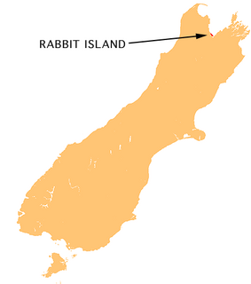
Moturoa / Rabbit Island is a small island located in the southernmost part of the Tasman Bay, in the northern coast of New Zealand's South Island. It lies across the southernmost part of Tasman Bay, at the top of New Zealand's South Island. The long narrow island runs east-west for 8 kilometres (5 mi), and covers 15 km2 (5.8 sq mi).

Lake Waikare is the largest of several shallow lakes in the upper floodplain of the Waikato River in New Zealand's North Island. It is a riverine lake, located to the east of Te Kauwhata and 40 kilometres north of Hamilton. It covers 34 km².

Paihia is the main tourist town in the Bay of Islands in the far north of the North Island of New Zealand. It is 60 kilometres north of Whangarei, located close to the historic towns of Russell and Kerikeri. Missionary Henry Williams named the mission station Marsden's Vale and eventually the Paihia became the accepted name of the settlement.
The Waitotara River in New Zealand's North Island stretches approximately 100 km in length from its headwaters in the Matemateaonga Ranges to its mouth on the South Taranaki Bight. The river takes in significant tributaries such as the Ngutuwera, Makakaho, Pokeka, Omaru and Totara Streams.
Waikare is a locality in Northland, New Zealand. The Waikare River flows from the Russell Forest past Waikare and into the Waikare Inlet, which leads into the Bay of Islands.

Whangarei District is a territorial authority district in the Northland Region of New Zealand that is governed by the Whangarei District Council. The district is made up in area largely by rural land, and includes a fifth of the Northland Region. It extends southwards to the southern end of Bream Bay, northwards to Whangaruru and almost to the Bay of Islands, and westwards up the Mangakahia River valley past Pakotai and almost to Waipoua Forest. It includes the Hen and Chicken Islands and the Poor Knights Islands.

The Kawakawa River is in the Northland Region of New Zealand's North Island. It flows predominantly eastward to Opua, where it joins the Waikare Inlet to flow into the Veronica Channel at the southern end of the Bay of Islands.
The Mangakahia River is a river of the Northland Region of New Zealand's North Island. It flows east from its sources in the Mataraua Forest, turning southeastward after about 20 kilometres (12 mi) on joining with the small Awarua River. It is joined by the Opouteke River near Pakotai, then turns east, until it is joined by the Hikurangi River. It then turns south again, passing Titoki and then joining with the Wairua River to form the Wairoa River approximately halfway between Whangarei and Dargaville.
The Mangapai River is a river of the Northland Region of New Zealand's North Island. It is perhaps better described as a silty arm of Whangarei Harbour, located 10 kilometres (6 mi) due south of Whangarei. Its average width is some 4 metres (13 ft), but the silty nature of its course means that the stream itself is far narrower.
The Omaru River is a river of the Northland Region of New Zealand's North Island. It flows generally north from several streams with origins northwest of Paparoa, reaching the Manganui River 20 kilometres northeast of Ruawai.
The Racehorse River is a river of the Northland Region of New Zealand's North Island. It flows southeast into Whangaruru Harbour 22 kilometres (14 mi) east of Paihia.
The Tongaporutu River is a river of the Taranaki Region of New Zealand's North Island. It initially flows north from its origins near Tahora, turning west to reach the Tasman Sea coast close to the settlement of Tongaporutu, 15 kilometres south of Mokau.
The Waionepu River is a river of the Northland Region of New Zealand's North Island. It flows generally west from its sources south of Maungatapere to reach the Waiotama River 20 kilometres southwest of Whangarei.
The Waiotama River is a river of the Northland Region of New Zealand's North Island. It flows northwest from its origins south of Maungatapere to reach the Wairua River 20 kilometres northeast of Dargaville.
The Whakapara River is a river of the Northland Region of New Zealand's North Island. One of the headwaters of the Wairua River, it flows generally east from its sources close to the North Auckland Peninsula's east coast, and reaches the Wairua 5 km (3.1 mi) west of Otonga.
The Whangae River is a river of the Northland Region of New Zealand's North Island. It flows generally northeast to reach a southwestern arm of the Bay of Islands.
The Waikare River is a river in the Bay of Plenty Region of New Zealand' North Island. It flows north from its origins between the peaks of Matawhio and Papakai north of Lake Waikaremoana to reach the Whakatane River 25 kilometres (16 mi) east of Murupara.

The Waitangi River is a river of the Northland Region of New Zealand's North Island. It flows east from its origins close to the northern shore of Lake Omapere, reaching the Bay of Islands close to the historic settlement of Waitangi.


