Waikohu River

Last updated

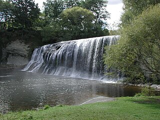
The Waikohu River is located in the northeast of New Zealand's North Island. A tributary of the Waipaoa River, it rises close to Matawai in the Raukumara Range and flows southeast, reaching the Waipaoa River close to the tiny settlement of Puha, between the settlements of Waikohu and Te Karaka.

New Zealand Country in Oceania

New Zealand is a sovereign island country in the southwestern Pacific Ocean. The country geographically comprises two main landmasses—the North Island, and the South Island —and around 600 smaller islands. New Zealand is situated some 2,000 kilometres (1,200 mi) east of Australia across the Tasman Sea and roughly 1,000 kilometres (600 mi) south of the Pacific island areas of New Caledonia, Fiji, and Tonga. Because of its remoteness, it was one of the last lands to be settled by humans. During its long period of isolation, New Zealand developed a distinct biodiversity of animal, fungal, and plant life. The country's varied topography and its sharp mountain peaks, such as the Southern Alps, owe much to the tectonic uplift of land and volcanic eruptions. New Zealand's capital city is Wellington, while its most populous city is Auckland.

North Island The northern of the two main islands of New Zealand

The North Island, also officially named Te Ika-a-Māui, is one of the two main islands of New Zealand, separated from the larger but much less populous South Island by Cook Strait. The island's area is 113,729 square kilometres (43,911 sq mi), making it the world's 14th-largest island. It has a population of 3,749,200.

Waipaoa River river in New Zealand

The Waipaoa River is a river of the northeast of New Zealand's North Island. It rises on the eastern slopes of the Raukumara Range, flowing south for 80 kilometres (50 mi) to reach Poverty Bay and the Pacific Ocean just south of Gisborne. For about half of this distance its valley is followed by State Highway 2. The river has several important tributaries, among them the Wharekopai, Waikohu, Mangatu, Waingaromia and Waihora rivers. Major settlements along the banks of the river include Te Karaka, Ormond, and Patutahi.

Coordinates: 38°29′S177°51′E / 38.483°S 177.850°E / -38.483; 177.850

Geographic coordinate system Coordinate system

A geographic coordinate system is a coordinate system that enables every location on Earth to be specified by a set of numbers, letters or symbols. The coordinates are often chosen such that one of the numbers represents a vertical position and two or three of the numbers represent a horizontal position; alternatively, a geographic position may be expressed in a combined three-dimensional Cartesian vector. A common choice of coordinates is latitude, longitude and elevation. To specify a location on a plane requires a map projection.


Related Research Articles

Poverty Bay bay

Tūranganui-a-Kiwa / Poverty Bay is the largest of several small bays on the east coast of New Zealand's North Island to the north of Hawke Bay. It stretches for 10 kilometres (6 mi) from Young Nick's Head in the southwest to Tuaheni Point in the northeast. The city of Gisborne is located on the northern shore of the bay and the small settlement of Muriwai is located at the bay's southern end. The name is often used by extension to refer to the entire area surrounding the city of Gisborne. Poverty Bay is the home of the iwi Te Aitanga-a-Māhaki, Rongowhakaata and Ngāi Tāmanuhiri.

Mount Arowhana lies in the Raukumara Range in the northeast of New Zealand's North Island. Part of the backbone of the range, which forms part of a line of mountains extending across much of the North Island, 1440 metre (4724 ft) Arowhana is second only to Mount Hikurangi in terms of height within the Raukumara Range.

Maungahaumi is a mountain in the Raukumara Range in the northeast of New Zealand's North Island.

Awapuni is a suburb of the New Zealand city of Gisborne, and is located in the southwest of the city. It is named after the Awapuni lagoon, where the Waipaoa River runs into the ocean.

Te Karaka is a small settlement inland from Gisborne, in the northeast of New Zealand's North Island. It is located in the valley of the Waipaoa River close to its junction with its tributary, the Waihora River. Te Karaka is located on State Highway 2, and is the largest settlement between Gisborne and Opotiki in the Bay of Plenty.

Patutahi is a small settlement 15 kilometres from Gisborne, in the northeast of New Zealand's North Island. It is located in the valley of the Waipaoa River.

Ormond is a small settlement inland from Gisborne, in the northeast of New Zealand's North Island. It is located on State Highway 2 in the valley of the Waipaoa River, halfway between Gisborne and the township of Te Karaka.

Manutuke is a settlement in the Gisborne Region of New Zealand's North Island. It is located to the west of the city of Gisborne on State Highway 2, close to the mouth of the Waipaoa River.

Whatatutu is a small settlement in the northeast of New Zealand's North Island. It is located north of Te Karaka on the upper reaches of the Waipaoa River, close to its meeting with its tributaries, the Mangatu and Waingaromia Rivers.

Wharekopae River river in New Zealand

The Wharekopae River is located in the northeast of New Zealand's North Island. A tributary of the Waikohu River, it rises on the slopes of Maungatapere, a 1,050-metre (3,440 ft) peak at the northeastern end of the Huiarau Range, and flows east, reaching the Waikohu River at the settlement of Waikohu, west of Te Karaka.

Puha or Puhatikotiko is a locality between the Waipaoa River and the Waikohu River in the Gisborne District of New Zealand's North Island. It is located close to the confluence of the two rivers on State Highway 2 close to Te Karaka, inland from the city of Gisborne.

Waikohu is a small settlement in the northeast of New Zealand's North Island. It is located close to the confluence of the Wharekopae and Waikohu Rivers on State Highway 2 to the west of Te Karaka, inland from Gisborne.

Waituhi is a small settlement in the northeast of New Zealand's North Island. It is located in the Tūranganui-a-Kiwa (Gisborne) region, 21 km northwest of the city of Gisborne, on the western bank of the Waipaoa River. It is notable as the historic site of Popoia pā, and as the location for several novels and short stories of Witi Ihimaera. Members of the Te Aitanga-a-Māhaki iwi are the tangata whenua. In 2009 a project to develop a community drinking water supply was started.

The Mangatu River is a river of the Gisborne Region of New Zealand's North Island. It flows south from its sources in rough hill country northeast of Matawai to reach the Waipaoa River at Whatatutu.

The Te Arai River is a river of the Gisborne Region of New Zealand's North Island. It flows generally north from its origins in rough hill country 20 kilometres (12 mi) north of Nuhaka before veering northeast past the township of Manutuke to reach the Waipaoa River five kilometres from the latter's outflow into Poverty Bay.

The Waihuka River is a river of the Gisborne Region of New Zealand's North Island. It flows generally east to reach the Waikohu River 10 kilometres (6 mi) west of Te Karaka. State Highway 2 follows the course of the Waihuka for part of its route between Te Karaka and Matawai.

The Waingaromia River is a river of the Gisborne Region of New Zealand's North Island. It flows generally southwest from its origins 25 kilometres (16 mi) west of Tolaga Bay to reach the Waipaoa River close to Whatatutu.

Chernomorsky, Chernomorskaya, or Chernomorskoye is the name of several inhabited localities in Russia.