Related Research Articles

The Taupo Volcanic Zone (TVZ) is a volcanic area in the North Island of New Zealand that has been active for the past two million years and is still highly active. Mount Ruapehu marks its south-western end and the zone runs north-eastward through the Taupo and Rotorua areas and offshore into the Bay of Plenty. It is part of the larger Central Volcanic Region that extends further westward through the western Bay of Plenty to the eastern side of the Coromandel Peninsula and has been active for four million years. The Taupo Volcanic Zone is widening east–west at the rate of about 8 mm per year. It is named after Lake Taupo, the flooded caldera of the largest volcano in the zone, the Taupo Volcano.

The Pink Terrace, or Te Otukapuarangi in Māori, and the White Terrace, also known as Te Tarata, were natural wonders of New Zealand. They were reportedly the largest silica sinter deposits on earth. Until recently, they were lost and thought destroyed in the 1886 eruption of Mount Tarawera, while new hydrothermal features formed to the south-west i.e. Waimangu Volcanic Rift Valley.

Rotorua is a city on the southern shores of Lake Rotorua from which the city takes its name, located in the Bay of Plenty Region of New Zealand's North Island. It is the seat of the Rotorua District, a territorial authority encompassing Rotorua and several other nearby towns. The majority of the Rotorua District is in the Bay of Plenty Region, but a sizeable southern section and a small western section are in the Waikato region. Rotorua is in the heart of the North Island, 60 kilometres south of Tauranga, 80 km (50 mi) north of Taupo, 105 km (65 mi) east of Hamilton, and 230 km (140 mi) southeast of the nation's most populous city, Auckland.
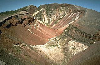
Mount Tarawera is a volcano on the North Island of New Zealand. Located 24 kilometres southeast of Rotorua, it consists of a series of rhyolitic lava domes that were fissured down the middle by an explosive basaltic eruption in 1886. This eruption was one of New Zealand's largest historical eruptions, and killed an estimated 120 people. The fissures run for about 17 kilometres northeast-southwest.

The Rotorua Caldera, a large rhyolitic caldera, is one of several large volcanoes located in the Taupo Volcanic Zone on the North Island of New Zealand. The caldera's last major eruption, about 240,000 years ago, had a Volcanic Explosivity Index of 7. At this time, the Mamaku ignimbrite, covering about 4,000 km2 (1,500 sq mi), was deposited. After the eruption, the magma chamber underneath the volcano collapsed. The circular depression left behind is the current caldera, about 22 km (14 mi) in diameter and now occupied by Lake Rotorua. Mokoia Island, close to the centre of the lake, is a rhyolite dome. There are other domes like Hinemoa Point, Ngongotahā, Pohaturoa and Pukeroa. The most recent magmatic eruption occurred less than 25,000 years ago, creating some of the smaller lava domes. The major regional settlement of Rotorua is located in the caldera. There is geothermal activity in the town of Rotorua.

Lake Rotomahana is an 800-hectare (2,000-acre) lake in northern New Zealand, located 20 kilometres to the south-east of Rotorua. It is immediately south-west of the dormant volcano Mount Tarawera, and its geography was substantially altered by a major 1886 eruption of Mount Tarawera. Along with the mountain, it lies within the Okataina caldera.

The Waimangu Geyser, located near Rotorua in New Zealand, was for a time the most powerful geyser in the world.

The Boiling Lake is a flooded fumarole located in Morne Trois Pitons National Park, a World Heritage site on the island of Dominica. The lake, located 6.5 miles (10.5 km) east of Dominica's capital Roseau, is filled with bubbling greyish-blue water that is usually enveloped in a cloud of vapour. The Boiling Lake is approximately 200 feet (61 m) to 250 feet (76 m) across and is the second-largest hot lake in the world after Frying Pan Lake, located in Waimangu Valley near Rotorua, New Zealand.
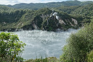
The Waimangu Volcanic Rift Valley is the hydrothermal system created on 10 June 1886 by the volcanic eruption of Mount Tarawera, on the North Island of New Zealand. It encompasses Lake Rotomahana, the site of the Pink and White Terraces, as well as the location of the Waimangu Geyser, which was active from 1900 to 1904. The area has been increasingly accessible as a tourist attraction and contains Frying Pan Lake, which is the largest hot spring in the world, and the steaming and usually pale blue Inferno Crater Lake, the largest geyser-like feature in the world although the geyser itself cannot be seen since it plays at the bottom of the lake.

Geothermal power in New Zealand is a small but significant part of the energy generation capacity of the country, providing approximately 17% of the country's electricity with installed capacity of over 900MW. New Zealand, like only a small number of other countries worldwide, has numerous geothermal sites that could be developed for exploitation, and also boasts some of the earliest large-scale use of geothermal energy in the world.

Frying Pan Lake is the world's largest hot spring. It is located in the Echo Crater of the Waimangu Volcanic Rift Valley, New Zealand and its acidic water maintains a temperature of about 50–60 °C (122–140 °F). The Lake covers 38,000 square meters in part of the volcanic crater and the shallow lake is only 18 feet deep, but at vents, it can go down to 60 feet.

The geology of New Zealand is noted for its volcanic activity, earthquakes and geothermal areas because of its position on the boundary of the Australian Plate and Pacific Plates. New Zealand is part of Zealandia, a microcontinent nearly half the size of Australia that broke away from the Gondwanan supercontinent about 83 million years ago. New Zealand's early separation from other landmasses and subsequent evolution have created a unique fossil record and modern ecology.
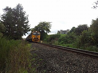
The Rotorua Branch is a railway line from Putaruru to Rotorua, in the Waikato and Bay of Plenty regions of the North Island of New Zealand. Construction of the line was commenced by the Thames Valley and Rotorua Railway Company and finished by the Public Works Department. The complete line, 50.5 kilometres (31.4 mi) in length, opened in two sections; on 24 November 1893 to Tarukenga and the final 8 mi 43 ch (13.7 km) to Rotorua on 8 December 1894.
The Kinleith Branch railway line is located in the Waikato region of New Zealand. The line was constructed by the Thames Valley and Rotorua Railway Company, Taupo Totara Timber Company and rebuilt by the Public Works Department primarily to serve the Kinleith Mill in 1952. It is 65 kilometres (40 mi) in length.
Located in a geologically active region, New Zealand has numerous geothermal features, including volcanoes, hot springs, geysers and volcanic lakes. Many of these features cluster together geographically, notably throughout the central North Island's Taupo Volcanic Zone. These areas attract scientific interest and tourism; power generators, industry and civil engineering also utilise them.

The Bay of Plenty is a bight in the northern coast of New Zealand's North Island. It stretches 260 km from the Coromandel Peninsula in the west to Cape Runaway in the east. The Bay of Plenty Region is situated around this body of water, also incorporating several large islands in the bay. The bay was named by James Cook after he noticed the abundant food supplies at several Māori villages there, in stark contrast to the earlier observations he had made in Poverty Bay.

Alfred Patchett Warbrick was a New Zealand boatbuilder, rugby player and tourist guide. Of Māori descent, he identified with the Ngāti Rangitihi and Te Arawa iwi.

Inferno Crater Lake is a large hot spring located in the Waimangu Volcanic Rift Valley on the North Island of New Zealand, and the largest geyser-like feature in the world. The actual geyser is not visible, as it plays underwater at the bottom of the lake, however, fumaroles are visible on the lake's shore and the rock wall behind it.

The 1886 eruption of Mount Tarawera occurred in the early hours of 10 June 1886 in the North Island near Rotorua then extended to Waimangu, New Zealand. It is the deadliest eruption in New Zealand since the arrival of Europeans. Around 120 people were killed, and many settlements were destroyed or buried.
References
- ↑ "Rotorua – The top 7 things to do with the kids!". New Idea. Retrieved 7 December 2019.
- ↑ "World Famous in New Zealand: Rotorua's Waimangu Volcanic Valley". Stuff. Retrieved 7 December 2019.
- ↑ "Pink and White Terraces brought back to life with Waimangu AR app". 29 November 2018. ISSN 1170-0777 . Retrieved 7 December 2019.
| This Bay of Plenty Region geography article is a stub. You can help Wikipedia by expanding it. |