
Brighouse is a town within the metropolitan borough of Calderdale, in West Yorkshire, England. Historically within the West Riding of Yorkshire, it is situated on the River Calder, 4 miles (6.4 km) east of Halifax. It is served by Junction 25 of the M62 motorway and Brighouse railway station on the Caldervale Line and Huddersfield Line. In the town centre is a mooring basin on the Calder and Hebble Navigation. The United Kingdom Census 2001 gave the Brighouse / Rastrick subdivision of the West Yorkshire Urban Area a population of 32,360. The Brighouse ward of Calderdale Council gave a population of 11,195 at the 2011 Census. Brighouse has a HD6 postcode.
Greetland is a village situated within the metropolitan borough of Calderdale, West Yorkshire, England. It falls within the Calderdale Ward of Greetland and Stainland. According to the 2011 Census, this ward had a population of 11,389. Geographically, Greetland is approximately 1 mile west of Elland and 2.5 miles south of Halifax.

Mytholmroyd is a large village and former civil parish, now in the parish of Hebden Royd, in the Calderdale district, in West Yorkshire, England, 2 miles (3 km) east of Hebden Bridge. It lies in the Upper Calder Valley, 10 miles (16 km) east of Burnley and 7 miles (11 km) west of Halifax. The village, which has a population of approximately 4,000, is in the Luddendenfoot Ward of Calderdale Council.

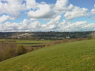
Rastrick is a village in the county of West Yorkshire, England, between Halifax, 5 miles (8 km) north-east and Huddersfield, 4 miles (7 km) south.

Ripponden is a village and civil parish on the River Ryburn near Halifax in West Yorkshire, England. Historically it was part of the West Riding of Yorkshire. Its population was 6,412 at the time of the 2001 Census, and 7,421 in 2011.

Copley is a village in the metropolitan borough of Calderdale, in the county of West Yorkshire, England, south of Halifax and east of Sowerby Bridge. It is situated by the River Calder and the Calder and Hebble Navigation canal.

Sowerby Bridge is a market town in the Upper Calder Valley in Calderdale in West Yorkshire, England. The Calderdale Council ward population at the 2011 census was 11,703.

Calderdale is a metropolitan borough of West Yorkshire, England, which had a population of 211,439. It takes its name from the River Calder, and dale, a word for valley. The name Calderdale usually refers to the borough through which the upper river flows, while the actual landform is known as the Calder Valley. Several small valleys contain tributaries of the River Calder. The main towns of the borough are Brighouse, Elland, Halifax, Hebden Bridge, Sowerby Bridge and Todmorden.

Halifax is a constituency represented in the House of Commons of the UK Parliament since 2024 by Kate Dearden of the Labour Party.

Luddenden is a district of Calderdale 3.1 miles (5 km) west of Halifax on the Luddenden Brook in the county of West Yorkshire, England.
Luddendenfoot or Luddenden Foot is a village in West Yorkshire, England. It is in the borough of Calderdale, to the northwest of Sowerby Bridge and west of Halifax. The population of Luddendenfoot is 2,547, with the wider Calderdale Ward having a population of 10,653 at the 2011 Census. The village lies along the Upper Calder Valley below Luddenden, between Sowerby Bridge and Mytholmroyd.

Shelf is a village in Calderdale in West Yorkshire, England. The village is situated approximately 3 miles (4.8 km) north-east of Halifax and 5 miles (8 km) south-west of Bradford, on the A6036 road. In 2001 it had a population of 4,496. At the 2011 Census Shelf was measured as part of the Calderdale ward of Northowram and Shelf.

Wainhouse Tower is a folly in the parish of King Cross, on the south-west side of Halifax, Calderdale, West Yorkshire, in England. At 275 feet (84 m), it is the tallest structure in Calderdale and the tallest folly in the world, and was erected between 1871 and 1875. The main shaft is octagonal in shape and has a square base and 369 steps leading to the first of two viewing platforms which is open to the public, and a total of 405 to the top viewing platform which is usually closed to the public. The tower is open to the public during bank holidays, and is a Grade II* listed building.

Dean Clough in Halifax, Calderdale, West Yorkshire, England, is a group of large factory buildings built in the 1840s–60s for Crossley's Carpets, becoming one of the world's largest carpet factories. After years of declining production it closed in 1983, when it was bought by a consortium led by Sir Ernest Hall which developed the Grade II listed site for various commercial and cultural uses. It is now seen as a leading example of successful urban regeneration. Dean Clough is located on the north side of Halifax near the Victorian North Bridge and the modern flyover sections of the Burdock Way relief road system. The converted mills now house about 150 large and small businesses and arts venues including Crossley Gallery and several other art galleries and the Viaduct Theatre, home base for the Northern Broadsides theatre company. Phoenix Radio 96.7 FM has its studios in D Mill and Lloyds Banking Group has offices in G Mill.

Halifax is a town in the Metropolitan Borough of Calderdale, in West Yorkshire, England. It is near the east Pennine foothills. In the 15th century, the town became an economic hub of the old West Riding of Yorkshire, primarily in woollen manufacture with the large Piece Hall square later built for trading wool in the town centre. The town was a thriving mill town during the Industrial Revolution with the Dean Clough Mill buildings a surviving landmark. In 2011, it had a population of 88,134. It is also the administrative centre of the wider Calderdale Metropolitan Borough.

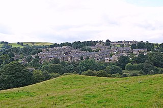
Barkisland is a village in Calderdale, West Yorkshire, England. Historically part of the West Riding of Yorkshire, it is 1 mile (1.6 km) east of Ripponden, 2 miles (3.2 km) south of Sowerby Bridge and 4 miles (6.4 km) south-west of Halifax town centre.
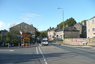
Holywell Green is a village in the civil parish of Stainland and District, in the Calderdale, district, in the county of West Yorkshire, England. The village is situated approximately 1.4 miles (2 km) south-west of Elland, 3.3 miles (5 km) south of Halifax and 3.9 miles (6 km) north-west of Huddersfield. Holywell Green is part of the Greetland and Stainland Ward of Calderdale Council.
Trinity Academy Grammar, formerly known as Trinity Academy Sowerby Bridge, is a coeducational secondary school in Sowerby Bridge, Calderdale, West Yorkshire, England. The school specialises in maths and computing, and is attended by over 1000 students.

Hannah Lucy Cockroft is a British wheelchair racer specialising in sprint distances in the T34 classification and TV presenter.

Calderdale Industrial Museum is a museum in the town of Halifax, West Yorkshire, England, dedicated to the industrial heritage of the area. The museum contains a number of working machines built between 1850 – 1930 all of which were either built or used in Halifax.
