
The Auckland Region is one of the sixteen regions of New Zealand, named for the city of Auckland, the country's largest urban area. The region encompasses the Auckland metropolitan area, smaller towns, rural areas, and the islands of the Hauraki Gulf. Containing 35 percent of the nation's residents, it has by far the largest population and economy of any region of New Zealand, but the second-smallest land area.

Tangiteroria is a small rural community in the North Island of New Zealand. It is located halfway between Whangarei and Dargaville on State Highway 14 on the banks of the Northern Wairoa river.

Ngamatapouri is a small rural locality in the Waitotara River valley, 47 km north of Waitotara village, in south Taranaki, New Zealand. Wanganui is about 80 km to the southeast. The road is sealed as far as the school.

Port Taranaki is a port complex located in New Plymouth, New Zealand. It is the only deep water port on the west coast of New Zealand, and is owned by the Taranaki Regional Council. The port handles a wide range of coastal and international cargoes, mostly relating to the farming, engineering and petrochemical industries. Shipping volumes decreased significantly over the period 2012 to 2015.

Whangarei District is a territorial authority district in the Northland Region of New Zealand that is governed by the Whangarei District Council. The district is made up in area largely by rural land, and includes a fifth of the Northland Region. It extends southwards to the southern end of Bream Bay, northwards to Whangaruru and almost to the Bay of Islands, and westwards up the Mangakahia River valley past Pakotai and almost to Waipoua Forest. It includes the Hen and Chicken Islands and the Poor Knights Islands.
The Hikurangi River is a river of Northland, New Zealand. A winding stretch of river, it can be considered an extension of the Kaikou River, being formed from the confluence of this river and the Moengawahine Stream. The Hikurangi flows south past the Pipiwai settlement for several kilometres before flowing into the Mangakahia River, 25 kilometres (16 mi) west of Whangarei.
The Kaikou River is a river of the Northland Region of New Zealand's North Island. It flows initially north, then east, and finally south, from its source approximately halfway between Dargaville and Kaikohe, before joining with the Moengawahine Stream to become the Hikurangi River.

The Kawakawa River is in the Northland Region of New Zealand's North Island. It flows predominantly eastward to Opua, where it joins the Waikare Inlet to flow into the Veronica Channel at the southern end of the Bay of Islands.
The Mangakahia River is a river of the Northland Region of New Zealand's North Island. It flows east from its sources in the Mataraua Forest, turning southeastward after about 20 kilometres (12 mi) on joining with the small Awarua River. It is joined by the Opouteke River near Pakotai, then turns east, until it is joined by the Hikurangi River. It then turns south again, passing Titoki and then joining with the Wairua River to form the Wairoa River approximately halfway between Whangarei and Dargaville.
The Oparau River is a river of the Waikato Region of New Zealand's North Island. It flows southwest from its sources in the Pirongia Forest Park and flows into the Kawhia Harbour 5 kilometres (3 mi) east of Kawhia.
The Otekaieke River is a river in New Zealand, a tributary of the Waitaki River.
The Te Naihi River is a river of the Otago region of New Zealand's South Island. It flows generally northwest to reach the Waiatoto River 35 kilometres (22 mi) southwest of Haast. Much of the river's length is within Mount Aspiring National Park.
The Tongaporutu River is a river of the Taranaki Region of New Zealand's North Island. It initially flows north from its origins near Tahora, turning west to reach the Tasman Sea coast close to the settlement of Tongaporutu, 15 kilometres south of Mokau.
The Waionepu River is a river of the Northland Region of New Zealand's North Island. It flows generally west from its sources south of Maungatapere to reach the Waiotama River 20 kilometres southwest of Whangarei.
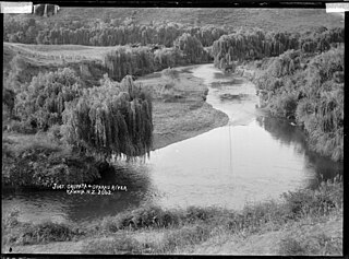
The Wairua River is a river of Northland, New Zealand. It flows south-west from Hikurangi and joins the Mangakahia River between Titoki and Tangiteroria to form the Wairoa River, which runs past Dargaville to the Kaipara Harbour.
The Whakapara River is a river of the Northland Region of New Zealand's North Island. One of the headwaters of the Wairua River, it flows generally east from its sources close to the North Auckland Peninsula's east coast, and reaches the Wairua 5 km (3.1 mi) west of Otonga.
Kenepuru is a primarily industrial suburb of the city of Porirua in New Zealand. It lies immediately southwest of the Porirua city centre.
Mount Porteus is a mountain just east of Peacock Ridge, in the Tula Mountains in Enderby Land. It was plotted from air photos taken from ANARE aircraft in 1956 and was named by the Antarctic Names Committee of Australia (ANCA) for W.F. Porteus, a member of the crew of the Discovery during the British Australian New Zealand Antarctic Research Expedition (BANZARE) of 1929-31.
The Waikare River is a river in the Northland Region of New Zealand's North Island. Rising in the Russell Forest, it flows into the southern end of the Waikare Inlet, a drowned valley which forms a southeastern arm of the Bay of Islands.

The Waitangi River is a river of the Northland Region of New Zealand's North Island. It flows east from its origins close to the northern shore of Lake Omapere, reaching the Bay of Islands close to the historic settlement of Waitangi.


