
The Hutt Valley is the large area of fairly flat land in the Hutt River valley in the Wellington region of New Zealand. Like the river that flows through it, it takes its name from Sir William Hutt, a director of the New Zealand Company in early colonial New Zealand.
The Ahuroa River is a river in the Northland Region of the North Island of New Zealand.
The North River is a stream in the Northland Region, New Zealand. The stream flows through limestone caves before entering the Pohuenui River, which in turn flows into the Waipu River before this emerges into Bream Bay near Waipu. The river also lends itself to a settlement on the river.

Moturoa / Rabbit Island is a small island that lies across the southernmost part of Tasman Bay / Te Tai-o-Aorere, on the northern coast of New Zealand's South Island. The long narrow island runs east–west for 8 kilometres (5 mi), and covers 15 km2 (5.8 sq mi).
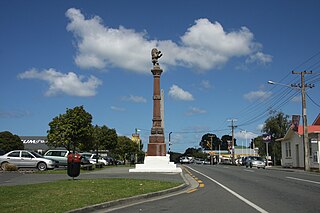
Waipu is a small town in Bream Bay, in the Northland Region of New Zealand. The town has a Scottish heritage; a highlight of the town's calendar is the annual Highland Games held at New Year. Near the town are the Waipu Caves, which contain a significant population of glow worms.

The New Zealand fairy tern or tara-iti is a subspecies of the fairy tern endemic to New Zealand. It is New Zealand's rarest native breeding bird, with about 40 individuals left in the wild. It nests at four coastal locations between Whangārei and Auckland in the North Island. It is threatened by introduced predators, extreme storms and tides, beach activity, and waterfront development.

The Eagles Nest is a complex of five rental villas in the Bay of Islands of New Zealand, a few kilometres north of Russell. Located on a headland above the sea with good views of the bay, the secured compound is the most expensive rental accommodation of New Zealand, with a single night costing up to a five-figure sum in New Zealand $, depending which of the villas are chosen. Guests are also provided with amenities like personal chefs and Porsche cars.

Whangarei District is a territorial authority district in the Northland Region of New Zealand that is governed by the Whangarei District Council. The district is made up in area largely by rural land, and includes a fifth of the Northland Region. It extends southwards to the southern end of Bream Bay, northwards to Whangaruru and almost to the Bay of Islands, and westwards up the Mangakahia River valley past Pakotai and almost to Waipoua Forest. It includes the Hen and Chicken Islands and the Poor Knights Islands.

The Hātea River is a river of New Zealand. It flows from the north-east of Whangārei southwards and into the northern head of Whangārei Harbour. Its lower length forms the eastern boundary of the city. The banks along the lower reaches are parks and bushland with a series of metalled walks suitable for all weathers.
The Manawapou River is a river of the Taranaki Region of New Zealand's North Island. It flows southwest, from its origins in rough hill country to the northeast of Hāwera, to reach the South Taranaki Bight between Hāwera and Patea.
The Mangakahia River is a river of the Northland Region of New Zealand's North Island. It flows east from its sources in the Mataraua Forest, turning southeastward after about 20 kilometres (12 mi) on joining with the small Awarua River. It is joined by the Opouteke River near Pakotai, then turns east, until it is joined by the Hikurangi River. It then turns south again, passing Titoki and then joining with the Wairua River to form the Wairoa River approximately halfway between Whangārei and Dargaville.
The Pohuenui River is a river of the Northland Region of New Zealand's North Island. It flows southeast, reaching the Waipu River close to the latter's mouth, immediately north of the town of Waipu.
The Waihoihoi River is a river of the Northland Region of New Zealand's North Island. it is a tributary of the Waipu River, which it reaches close to the town of Waipu.
The Wairua River is a river of Northland, New Zealand. It flows south-west from Hikurangi and joins the Mangakahia River between Titoki and Tangiteroria to form the Wairoa River, which runs past Dargaville to the Kaipara Harbour.

Bream Bay is an embayment and area south-east of Whangārei, on the east coast of New Zealand. The bay runs from Bream Head, at the mouth of Whangārei Harbour, 22 kilometres south to the headland of Bream Tail, east of Langs Beach and north of Mangawhai. It was named by Captain James Cook. The Bream Bay area includes the towns of Ruakākā, One Tree Point and Waipu. A group of nature reserve islands lie outside Bream Bay: the Hen and Chicken Islands and Sail Rock.
The Waipu Lagoons is a series of small coastal lagoons near the city of New Plymouth in the Taranaki Region of New Zealand. They consist of three lakelets with a combined surface area of about 2 hectares, located 0.5 kilometres (0.31 mi) from the Tasman Sea, immediately to the east of Bell Block. The lagoons and adjoining wetlands encompass 7.9 hectares and are owned by the New Plymouth District Council as a local purpose conservation reserve.

Mair Park is in Whangārei, New Zealand, adjacent to the suburb of Mairtown. It is named for Robert Mair, who donated the land from his estate to the city in 1914. The park includes access to the Hātea River. Access to the park is off Rurumoki Street.
Uretiti Beach is a stretch of beach between Ruakākā and Waipu on Bream Bay to the south of Whangārei in Northland, New Zealand. It comprises the coastal side of the Uretiti Recreation Reserve and Uretiti Scenic Reserve, and is served by a Department of Conservation (DOC) campground within the Recreation Reserve. Uretiti Beach is popular for swimming, surfing, and fishing, a well-known clothing-optional beach, and camping area for the LGBTQ+ community over the New Year period.

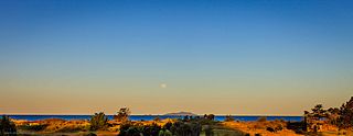
Waipu Cove is a locality and bay of Bream Bay in the Whangarei District and Northland Region of New Zealand. It is about 9 km southeast of Waipu and 5 km northwest of Langs Beach. It has a long sandy beach.
