Related Research Articles
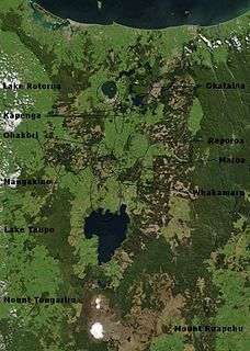
The Taupō Volcanic Zone (TVZ) is a volcanic area in the North Island of New Zealand that has been active for the past two million years and is still highly active.

The Thames-Coromandel District is a territorial authority district in the North Island of New Zealand, covering all the Coromandel Peninsula and extending south to Hikutaia.
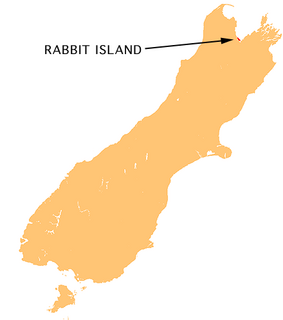
Moturoa / Rabbit Island is a small island that lies across the southernmost part of Tasman Bay / Te Tai-o-Aorere, on the northern coast of New Zealand's South Island. The long narrow island runs east–west for 8 kilometres (5 mi), and covers 15 km2 (5.8 sq mi).

The Firth of Thames is a large bay located in the north of the North Island of New Zealand. It is the firth of the rivers Waihou and Piako, the former of which was formerly named the Thames River, and the town of Thames lies on its southeastern coast.
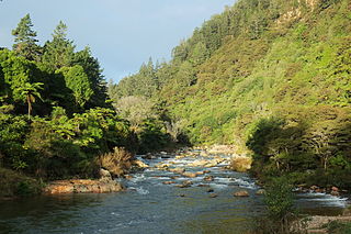
The Ohinemuri River is located in the northern half of New Zealand's North Island, at the base of the Coromandel Peninsula.
The Thames Valley is a non-administrative region in the North Island of New Zealand. Broadly, it is the valley component of the Waihou River catchment. The lower part of the valley is more commonly known as the Hauraki Plains. Geographically the valley extends as far as the Hinuera Gap, although this is not often referred to as such. In geographical history of New Zealand, the Thames Valley was the path of the ancestral Waikato River when it discharged into the Firth of Thames over 20,000 years ago.

The Tairua River is located on the Coromandel Peninsula in the North Island of New Zealand.

Slipper Island is located 3 kilometres (1.9 mi) to the east of the Coromandel Peninsula in New Zealand's North Island and 8 kilometres (5 mi) southeast of the town of Pauanui.
Hikutaia is a locality on the Hauraki Plains of New Zealand. It lies on State Highway 26, south east of Thames and north of Paeroa. The Hikutaia River runs from the Coromandel Range through the area to join the Waihou River.

Manaia is a locality on the western side of the Coromandel Peninsula of New Zealand. It lies to the east of State Highway 25, south of Coromandel and north of Tapu. The Manaia River flows from the Coromandel Range through the area and into the Manaia Harbour to the west. The harbour contains mussel farms.
The Hikutaia River is a river of New Zealand's North Island. It has its source in several streams which flow west from the Coromandel Range, the longest of which is the Waipaheke Stream. The river generally flows west, reaching its outflow into the Waihou River 10 kilometres (6 mi) north of Paeroa on the edge of the Hauraki Plains.
The Kauaeranga River is a river of New Zealand's North Island. One of the main rivers on the Coromandel Peninsula, it rises in the Coromandel Range which forms the backbone of the peninsula, flowing southwest through the Kauaeranga Valley to reach the Firth of Thames at Thames
The Komata River is a river of New Zealand's North Island. It flows west from the Coromandel Range, reaching the Waihou River just north of Paeroa.
The Opitonui River is a river of the Coromandel Peninsula in New Zealand's North Island. It flows north to reach the peninsula's east coast at Whangapoua Harbour, close to the small settlement of Te Rerenga. The river provides a water supply for Matarangi by way of a pipe laid across the Whangapoua harbour.
The Otahu River is a river of the Coromandel Peninsula, in the Waikato Region of New Zealand's North Island. It flows generally northeast from several streams with watersheds in the Coromandel Range, most notably the Wharekirauponga Stream. The Otahu reaches the sea immediately to the south of the town of Whangamatā.
The Puriri River is a river of the Waikato Region of New Zealand's North Island. It flows west close to the point where the Coromandel Peninsula joins the rest of the North Island, reaching the Waihou River 3 kilometres (2 mi) east of Turua.
The Waitekuri River is a river of the Coromandel Peninsula in New Zealand's North Island. It flows east from its sources in the Coromandel Range east of Coromandel to reach Whangapoua Harbour four kilometres south of Whangapoua.
The Wentworth River is a river of the Coromandel Peninsula, in the Waikato Region of New Zealand's North Island. It flows northeast from the Coromandel Range to reach the Bay of Plenty at Whangamata.
The Wharekawa River is a river of the Coromandel Peninsula, in the Waikato Region of New Zealand's North Island. It flows northeast to reach the Wharekawa Harbour halfway between Pauanui and Whangamata.
Thames-Coromandel District Council is the territorial authority for the Thames-Coromandel District of New Zealand. The council consists of the mayor of Thames-Coromandel and 8 ward councillors. There are also five community boards.
References
"Place name detail: Waitekauri River". New Zealand Gazetteer. New Zealand Geographic Board . Retrieved 12 July 2009.
| General | |
|---|---|
| National libraries | |
Coordinates: 37°23′S175°47′E / 37.383°S 175.783°E