Related Research Articles

Volkmarsen is a small town in Waldeck-Frankenberg district in northern Hesse, Germany. It is home to 6840 residents.

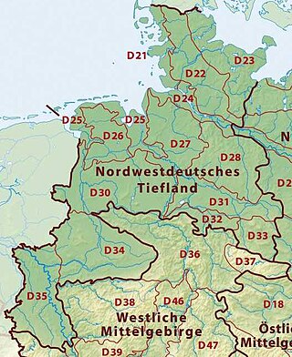
This division of Germany into major natural regions takes account primarily of geomorphological, geological, hydrological, and pedological criteria in order to divide the country into large, physical units with a common geographical basis. Political boundaries play no part in this, apart from defining the national border.
The Westphalian Lowland, also known as the Westphalian Basin is a flat landscape that mainly lies within the German region of Westphalia, although small areas also fall within North Rhine and in Lower Saxony. Together with the neighbouring Lower Rhine Plain to the west, it represents the second most southerly region of the North German Plain, after the Cologne Bight. It is variously known in German as the Westfälische Bucht, the Münsterländer or Westfälische Tieflands- or Flachlandsbucht.

The West Hesse Highlands, also known as the West Hessian Lowlands and Highlands, are a heavily forested region of the Central Uplands in Germany. These highlands lie mainly within the state of Hesse, between that part of the Rhenish Massif right of the Rhine in the west, the Weser Uplands to the north, the Hessian Central Uplands to the east and the Wetterau to the south.
The Upper Palatine-Bavarian Forest, is a natural region in Germany in the northeast of Bavaria. It mainly comprises the low mountain ranges of the Bavarian Forest and Upper Palatine Forest which are up to 1456 m high and border on the Bohemian Massif immediately inside the Czech Republic's southwestern border with Germany.

The Gäu Plateaus form the largest natural region in the German state of Baden-Württemberg. Not surprisingly, the individual geographical units of this large region show considerable variations in climate and soil types. A common feature of the region, however, is its landscape of flat-topped hills of Muschelkalk, gently rolling tracts of loess and plateaus in which the layers of Muschelkalk have been covered by sediments of Gipskeuper and Lettenkeuper.

The Leine Uplands is a region in Germany's Central Uplands which forms a part of the Lower Saxon Hills and lies along the River Leine between Göttingen and Hanover. It borders on the Weser Uplands in the west, the Innerste Uplands in the northeast, the Harz in the east and Untereichsfeld in the southeast.
The Franconian Keuper-Lias Plains or Franconian Keuper-Lias Lands are a major natural region in the South German Scarplands in Upper Franconia and to a lesser extent in the north, in the Thuringian district of Hildburghausen. As the name indicates, the term embraces both the Keuper landscapes and lias landscapes in Franconia. In addition, the fore-land of the Franconian Jura, in which part of the Brown Jurassic occurs, as well as parts of the former volcanic region of Heldburger Gangschar belong to this region.
The Beckum Hills, named after the town of Beckum, are a range of low hills, up to 174.4 m above sea level (NN), in the region of Münsterland in the German state of North Rhine-Westphalia (Germany). Along with the Baumberge and its foothills and the Haltern Hills they are among the few prominent elevations in the otherwise gently rolling Münsterland, the River Werse passes the ridge at 100 m to the east and the Lippe passing it at a height of 60 m near Hamm-Uentrop at some distance away from their highest point.
The Saar-Nahe Hills or Saar-Nahe Uplands is a major natural region in the German states of Rhineland-Palatinate and the Saarland. The region of hills and mountains covers an area of 4,185 km² running from Saarbrücken, Kaiserslautern and the Palatine Forest in the south to the Hunsrück in the northeast. It contains the catchment area of the Nahe as far as Bad Kreuznach as well as small sections of the Middle Saar in the west.

The Leininger Sporn is a highly prominent ridge in the northeast of the Palatinate Forest in western Germany, mainly composed of the rock formations of the Middle and Upper Bunter. It forms the western edge of Upper Rhine Plain between Grünstadt in the north and Leistadt, a village in the county of Bad Dürkheim, in the southeast. In the natural region system of the German Central Uplands it is considered one of the four sub-units of the Middle Palatinate Forest.

The Hochberg is a 635.3-metre-high mountain in the central Haardt in the Palatine Forest in Germany. It lies on the territory of the municipality of Sankt Martin (Palatinate) in the county of Südliche Weinstraße in the state of Rhineland-Palatinate. After the Kalmit, the Kesselberg and the Roßberg it is the fourth highest peak in the Palatine Forest.

The High Fichtel Mountains, or High Fichtel, form a mountainous and heavily forested range consisting of several mountain chains in the shape of a horseshoe, the Fichtel Mountain Horseshoe (Fichtelgebirgs-Hufeisen), that rings the Selb-Wunsiedel Plateau.

The Westrich Plateau, also Zweibrücken Westrich or Southwest Palatine Plateau, is a landscape in the German state of Rhineland-Palatinate, with small areas also in the Saarland (Saarpfalz-Kreis). Its heart is in the southwest of the Palatinate region and it is part of the historic region of Westrich.
The Upper Palatine-Upper Main Hills, also called the Upper Palatine-Upper Main Hills and Uplands form a landscape of low, rolling hills between the Franconian Jura in the southwest and the Franconian Forest, Fichtel Mountains and Upper Palatine Forest in the northeast.
The North Brandenburg Plateaux and Upland is a natural region in the northwest of Brandenburg and, to a lesser extent, the southwest of Mecklenburg-Vorpommern and northeast of Saxony-Anhalt in Germany. It is major unit group no. 77 in the natural regional divisions of Germany. The Brandenburg portion of the North Brandenburg Plateaux and Upland is largely coextensive with the natural region of Prignitz and Ruppin Land in the structural atlas of the state of Brandenburg.
The Venn Foreland is a region of the North Eifel on the northwestern edge of the High Fens and in its transition zone with the Jülich-Zülpich Börde. Also part of the region are the areas around the city of Aachen and town of Stolberg as well as parts of Eschweiler. It is a heavily built-up area and includes the largest part of the Aachen Municipal Region. Even parts of the High Fens-Eifel Nature Park belong to it. The valley of the river Inde forms its boundary with the High Fens. The region is hilly with an average height of 200 metres and rising to just over 350 metres above sea level. Its highest point is the Brandenberg in the Aachen Forest at 355.4 m above sea level (NHN).

The Salzungen Werra Upland is a natural region in Germany that forms part of the East Hesse Highlands in the German states of Hesse and Thuringia.
As well as being a low mountain range, the Westerwald is also a natural region in the system of natural regional division of Germany. Within that it is a major unit group with the number "32". According to this system the major unit group of the Westerwald belongs to the basement plate (Grundgebirgsschollenland), which describes the type of mountain-building process by which it was formed. The major unit group extends across the states of Hesse, North Rhine-Westphalia and Rhineland-Palatinate. It is roughly bounded by the valleys of the Lahn, Rhine and Sieg, whereby the hills immediately south of the Heller and Sieg are not considered to be part of it.
The Falkensteiner Vorwald is the gently rolling westernmost part of the Bavarian Forest in northern Lower Bavaria and southern Upper Palatinate in the German state of Bavaria.
References
- 1 2 E. Meynen und J. Schmithüsen: Handbuch der naturräumlichen Gliederung Deutschlands - Bundesanstalt für Landeskunde, Remagen 1953-1961
- 1 2 Martin Bürgener: Geographische Landesaufnahme: Die naturräumlichen Einheiten auf Blatt 111 Arolsen - Bundesanstalt für Landeskunde, Bad Godesberg 1963
- ↑ Map and description in Umweltatlas Hessen