
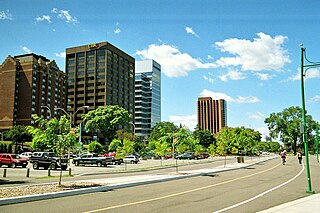
Windsor is a city in southwestern Ontario, Canada, on the south bank of the Detroit River directly across from Detroit, Michigan, United States. Geographically located within but administratively independent of Essex County, it is the southernmost city in Canada and marks the southwestern end of the Quebec City–Windsor Corridor. The city's population was 229,660 at the 2021 census, making it the third-most populated city in Southwestern Ontario, after London and Kitchener. The Detroit–Windsor urban area is North America's most populous trans-border conurbation, and the Ambassador Bridge border crossing is the busiest commercial crossing on the Canada–United States border.

King's Highway 401, commonly referred to as Highway 401 and also known by its official name as the Macdonald–Cartier Freeway or colloquially referred to as the four-oh-one, is a controlled-access 400-series highway in the Canadian province of Ontario. It stretches 828 kilometres (514 mi) from Windsor in the west to the Ontario–Quebec border in the east. The part of Highway 401 that passes through Toronto is North America's busiest highway, and one of the widest. Together with Quebec Autoroute 20, it forms the road transportation backbone of the Quebec City–Windsor Corridor, along which over half of Canada's population resides. It is also a Core Route in the National Highway System of Canada. The route is maintained by the Ministry of Transportation of Ontario (MTO) and patrolled by the Ontario Provincial Police. The speed limit is 100 km/h (62 mph) throughout its length, with the only exceptions the posted 80 km/h (50 mph) limit westbound in Windsor and in most construction zones, along with a 110 km/h (68 mph) speed limit between Windsor and Tilbury.

King's Highway 3, commonly referred to as Highway 3, is a provincially maintained highway in the Canadian province of Ontario which travels parallel to the northern shoreline of Lake Erie. It has three segments, the first of which travels from the Ambassador Bridge in Windsor to Highway 77 in Leamington. The second portion begins at Talbotville Royal outside of St. Thomas at Highway 4, and travels to the western city limits of Port Colborne. The road is regionally maintained within Port Colborne as Niagara Regional Road 3, but regains its provincial designation at Highway 140. Its third and final terminus is at Edgewood Park, within the Fort Erie town limits. From there, the road continues as Niagara Regional Road 3 to the Peace Bridge, where drivers can cross to the United States. The total length of Highway 3 is 258.2 km (160.4 mi), consisting of 49.2 km (30.6 mi) from Windsor to Leamington, 187.9 km (116.8 mi) from Talbotville Royal to Port Colborne and 21.1 km (13.1 mi) from Port Colborne to Edgewood Park.
The E. C. Row Expressway is a municipal expressway in the city of Windsor, Ontario, Canada. It divides the city in half as it crosses it between the Ojibway Parkway in the west and Banwell Road in the east, a distance of 15.4 kilometres (9.6 mi). It was built between 1971 and 1983, reaching completion across the city on June 9, 1983. It was part of Highway 2 and Highway 18 until the province transferred ownership and responsibility for the route to the City of Windsor on April 1, 1997. In 2015, the westernmost 3 kilometres (1.9 mi) was significantly upgraded as part of the Highway 401 extension project. The freeway is named after Edward Charles Row, the president of Chrysler Canada between 1951 and 1956.
Harrow is a community located in the town of Essex, Essex County, Ontario, Canada.

King's Highway 2, commonly referred to as Highway 2, is the lowest-numbered provincially maintained highway in the Canadian province of Ontario, and was originally part of a series of identically numbered highways which started in Windsor, stretched through Quebec and New Brunswick, and ended in Halifax, Nova Scotia. Prior to the 1990s, Highway 2 travelled through many of the major cities in Southern Ontario, including Windsor, Chatham, London, Brantford, Hamilton, Burlington, Mississauga, Toronto, Oshawa, Belleville, Kingston and Cornwall, amongst many other smaller towns and communities.
King's Highway 402, commonly referred to as Highway 402 and historically as the Blue Water Bridge Approach, is a 400-series highway in the Canadian province of Ontario that connects the Blue Water Bridge international crossing near Sarnia to Highway 401 in London. It is one of multiple trade links between Ontario and the Midwestern United States. It is four lanes for much of its length, though the approach to the Blue Water Bridge is six lanes.
Highbury Avenue is an arterial road located in the Canadian province of Ontario. In addition to serving as a primary north–south thoroughfare in eastern London – through which part of it is a limited-access freeway – the road also provides access to Highway 401 and continues south to St. Thomas. The southern terminus of Highbury Avenue is an intersection with South Edgeware Road, just north of Highway 3 and the eastern end of the St. Thomas Expressway. From there, it travels 45.6 kilometres (28.3 mi) north to Highway 7, east of Elginfield. Outside of London and St. Thomas, the road also passes through the communities of Ballymote and Bryanston. It is designated as Elgin County Road 30 within Central Elgin, and as Middlesex County Road 23 within Middlesex Centre, the two rural municipalities through which the route passes.

Walkerville, Ontario, is a former town in Canada, that is today a heritage precinct of Windsor, Ontario. The town was founded by Hiram Walker in 1890, owner and producer of Canadian Club Whisky. Walker planned it as a 'model town’,, that would be the envy of both the region and the continent. He established a distillery on the Detroit River and grew his business by growing grain, milling flour, and raising cattle and hogs. Later, the town supported other major industries, notably automotive manufacturing. It was annexed to Windsor, July 1, 1935.

Essex Terminal Railway is a Canadian shortline terminal railroad, running from the City of Windsor, Ontario through LaSalle, to Amherstburg, Ontario, for a distance of approximately 21 miles (34 km). ETR has direct connections to Canadian Pacific Railway, Canadian National Railway and CSX. ETR is owned by Essex Morterm Holdings. Founded in 1902, it is one of the oldest existing railways in Canada.
The Chrysler Canada Greenway is a 42 km-long rail trail in Essex County, Ontario, Canada, stretching from Oldcastle to Leamington.
The Veterans Memorial Parkway is a 13.4 kilometre expressway located in the Canadian province of Ontario. The expressway was previously known as King's Highway 100 from 1977 until 1993, and as Airport Road from 1977 to September 2006. It is currently an at-grade divided four-lane road located entirely within London. The parkway begins in the south as Wilton Grove Road and ends at Clarke Road, which it continues as northward.
King's Highway 40, commonly referred to as Highway 40, is a provincially maintained highway in the southwestern portion of the Canadian province of Ontario. The 91.4-kilometre (56.8 mi) route links Chatham and Sarnia via Wallaceburg, following close to the St. Clair River. The southern terminus is at Highway 401 south of Chatham, while the northern terminus is at Highway 402 in Sarnia. The portion of Highway 40 between Highway 401 and north of Wallaceburg is within the municipality of Chatham-Kent, while the portion north of there is within Lambton County.
The Roy A. Battagello River Walk Bike Trail is the current backbone of the "Windsor Loop" bike trail network in Windsor, Ontario. The bike trail travels from the foot of the Ambassador Bridge, to traffic lights at Riverside Drive and Lincoln Avenue. This makes the trail the second-longest trail in the City of Windsor, at 8.0 km.
Windsor, Ontario has a very diverse population, and this diversity is shown in its many neighbourhoods. Windsor has twenty in all, ranging from rural farmland to densely built-up areas.
King's Highway 77, commonly referred to as Highway 77, is a provincially maintained highway in the Canadian province of Ontario. One of three highways within Essex County, Highway 77 serves to interconnect Highway 3 near Leamington with Highway 401 near Tilbury. Prior to 1998, the highway extended south into Leamington, ending at the former routing of Highway 3 and Highway 18. This section was turned over to Essex County and renamed Erie Street. The speed limit on Highway 77 is 80 km/h (50 mph) in most places, dropping to 50 km/h in built-up areas. It is patrolled by the Ontario Provincial Police.
King's Highway 39, commonly referred to as Highway 39, was a provincially maintained highway in the Canadian province of Ontario. The 33.8-kilometre (21.0 mi)-long route connected Highway 3 in downtown Windsor with Highway 2 south of Belle River, travelling along the southern shoreline of Lake St. Clair. Highway 39 was established in 1934. By 1961, the Pike Creek Bypass was opened and Highway 39 was rerouted along it, with the former route briefly becoming Highway 39B. The route was renumbered as Highway 2 in 1970, retiring the designation from the provincial highway system. Highway 2 was itself decommissioned along the former route of Highway 39 on January 1, 1998, and transferred to Essex County and the City of Windsor. It was subsequently redesignated as Essex County Road 22.
King's Highway 98, commonly referred to as Highway 98, was a provincially maintained highway in the Canadian province of Ontario, designated as part of the provincial highway system between 1939 to 1971. The route travelled through the northern part of Essex County and through south-central Chatham-Kent, extending 96.3 kilometres (59.8 mi) from Windsor to Blenheim.