Wang Burapha Phirom subdistrict

Last updated
Wang Burapha Phirom
วังบูรพาภิรมย์
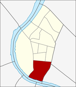
2016 Bangkok, Dystrykt Phra Nakhon, Kladka dla pieszych na skrzyzowaniu.jpg
Wang Burapha Intersection in front of Mega Plaza Saphan Lek, where Chak Phet meets Yaowarat, Phiraphong, and Maha Chai Roads.
Khwaeng 100102.png
CountryFlag of Thailand.svg  Thailand
Province Bangkok
Khet Phra Nakhon
Area
[1]
  Total0.720 km2 (0.278 sq mi)
Population
 (2017)
  Total11,427
Time zone UTC+7 (ICT)
Postal code
10200
TIS 1099 100102

Wang Burapha Phirom is a khwaeng (subdistrict) of Phra Nakhon District, in Bangkok, Thailand. In 2017 it had a total population of 11,427 people. [2]

Contents

History

Its name is after Wang Burapha Phirom, a former palace of Prince Bhanurangsi Savangwongse. The palace was demolished in the 1950s to build a shopping district and three cinemas in the name of "Wang Burapha". Wang Burapha can be considered as the centre of youngsters of that era comparable to Siam Square in present.

During King Rama V's reign, the area was named "Tambon Pak Khlong Talat" eponymous Pak Khlong Talat, a large local wet market by the Chao Phraya River and Khlong Lot.

Memorial Bridge and Memorial Bridge Pier (N6) that serves as stop for Chao Phraya Express Boat. Bkksaphanphut0609.jpg
Memorial Bridge and Memorial Bridge Pier (N6) that serves as stop for Chao Phraya Express Boat.

Currently, the palace location has become a Mega Plaza Saphan Lek, the department store that became the new hub of various kinds of toys and models after nearby Saphan Lek and Khlong Thom was rezoned by Bangkok Metropolitan Administration (BMA) in 2015.

Geography

Wang Burapha Phirom is the southernmost part of Phra Nakhon District. The lower area is entirely adjacent to the Chao Phraya River. It can also be considered as the southern end of the double old city moats, Khlong Khu Mueang Doem or colloquially known as Khlong Lot, and Khlong Rop Krung or Khlong Ong Ang. The two moats form a historic area called Rattanakosin Island.

Related Research Articles

<span class="mw-page-title-main">Phra Nakhon district</span> District of Bangkok

Phra Nakhon is one of the 50 districts (khet) of Bangkok, Thailand. It is the central district of Bangkok, including Rattanakosin Island. Neighboring districts are, from the north, clockwise: Dusit, Pom Prap Sattru Phai, Samphanthawong, and across the Chao Phraya River, Thon Buri, Bangkok Yai, Bangkok Noi, and Bang Phlat.

<span class="mw-page-title-main">Charoen Krung Road</span> Road in Bangkok

Charoen Krung Road is a major road in Bangkok and the first in Thailand to be built using modern construction methods. Built during 1862–1864 in the reign of King Mongkut, it runs from the old city centre in Rattanakosin Island, passes through Bangkok's Chinatown, continues into Bang Rak district, where it formerly served the community of European expatriates, and ends in Bang Kho Laem. Construction of the road marked a major change in Bangkok's urban development, with the major mode of transport shifting from water to land. Charoen Krung Road was Bangkok's main street up to the early 20th century, but later declined in prominence. It is still home to many historic buildings and neighbourhoods, which are beset by changes as extension of the underground MRT is poised to drive new development.

<span class="mw-page-title-main">Phra Pok Klao Bridge</span> Bridge in Bangkok, Thailand

Phra Pok Klao Bridge is a bridge crossing the Chao Phraya River in Bangkok, Thailand. It serves to connect the two sides of the Chao Phraya River in the Bangkok area, namely Phra Nakhon District's Wang Burapha Phirom and Samphanthawong District's Chakkrawat with Khlong San District's Somdet Chao Phraya as well as Thonburi District's Wat Kanlaya.

<span class="mw-page-title-main">Pak Khlong Talat</span>

Pak Khlong Talat is a market in Wang Burapha Phirom Subdistrict, Phra Nakhon District, Bangkok, Thailand, that sells flowers, fruits, and vegetables. It is the primary flower market of Bangkok and has been cited as a "place of symbolic value" to Bangkok residents. It is on Chak Phet Road and adjacent side-streets, close to Memorial Bridge. Though the market is open 24 hours, it is busiest before dawn, when boats and trucks arrive with flowers from nearby provinces. Its location by Chao Phraya River near the southern end of Khlong Lot, hence the name 'Pak Khlong Talat', literally means "the market on the mouth of the canal".

<span class="mw-page-title-main">Ban Mo, Bangkok</span>

Ban Mo is the name of a street and its corresponding neighbourhood in Bangkok's Wang Burapha Phirom Subdistrict, Phra Nakhon District. It is located just outside the old inner moat in the historic Rattanakosin Island area. The road runs a short distance of 0.6 kilometres (0.37 mi) from Si Kak Phraya Si Intersection, where it meets Charoen Krung and Fueang Nakhon roads, to meet Chak Phet Road in the Pak Khlong Talat area. It passes the beginning of Phahurat Road at Ban Mo Intersection. It can be considered a road with one-way traffic management.

<span class="mw-page-title-main">Bang Lamphu</span> Neighborhood in Bangkok, Thailand

Bang Lamphu or spelled Banglampoo and Banglamphu is a neighbourhood in Bangkok located in Phra Nakhon District. The history of the Bang Lamphu community dates to the establishment of the Rattanakosin Kingdom, or earlier. Bang Lamphu covers an area north of Phra Nakhon both inside and outside Rattanakosin Island from Phra Athit to Samsen Roads, which leads toward Dusit District. Most of the area of Bang Lamphu is in Talat Yot Subdistrict, some have spread to various nearby subdistricts including Chana Songkhram, Bowon Niwet, Ban Phan Thom up till Wat Sam Phraya.

<span class="mw-page-title-main">Saphan Hok</span> Bridge in Bangkok, Thailand

Saphan Hok is a bridge over the old city moat or Khlong Khu Mueang Doem in Bangkok's Phra Borom Maha Ratchawang and Wang Burapha Phirom sub-districts, Phra Nakhon district. The bridge is located right in front of the entrance to Saranrom Park.

<span class="mw-page-title-main">Saphan Han</span> Bridge in Thailand

Saphan Han is a small bridge over the Khlong Rop Krung, also known as Khlong Ong Ang in the areas of Bangkok's Chakkrawat sub-district, Samphanthawong district and Wang Burapha Phirom sub-district, Phra Nakhon district. It is also the name of the surrounding area.

<span class="mw-page-title-main">Atsadang Road</span> Road in Bangkok, Thailand

Atsadang Road is a road in inner Bangkok overlaps four Subdistricts of Phra Nakhon District, Bowon Niwet, San Chaopho Suea, Wat Ratchabophit, and Wang Burapha Phirom. It's starting from Ratchadamnoen Avenue in the area beside Sanam Luang and Phan Phiphop Lila Bridge pass through to the end at the junction of Chakkraphet Road and Charoen Rat 31 Bridge in the area of Pak Khlong Talat behind Ban Mo neighbourhood near the Chao Phraya River. Khlong Khu Mueang Doem or Khlong Lot and Rachini Road parallel to the road for its entire length of 1.6 km (1.0 mi).

<span class="mw-page-title-main">Phra Borom Maha Ratchawang subdistrict</span> Khwaeng in Thailand

Phra Borom Maha Ratchawang is a khwaeng (subdistrict) of Phra Nakhon District, in Bangkok, Thailand. In 2017 it had a total population of 3,953 people.

<span class="mw-page-title-main">Chak Phet Road</span>

Chak Phet Road is a road in Wang Burapha Phirom Subdistrict, Phra Nakhon District, Bangkok, with a total length of 1,120 m.

<span class="mw-page-title-main">Bang Lamphu Lang</span> Khwaeng in Thailand

Bang Lamphu Lang is a khwaeng (subdistrict) of Khlong San district, Bangkok's Thonburi side.

<span class="mw-page-title-main">Somdet Chao Phraya subdistrict</span> Sub-district of Bangkok, Thailand

Somdet Chao Phraya is one of the four khwaengs (subdistrict) of Khlong San district, Bangkok's Thonburi side.

<span class="mw-page-title-main">Khlong San subdistrict</span> Khwaeng in Thailand

Khlong San is a khwaeng (subdistrict) of Khlong San District on Bangkok's Thonburi side. It is the location of the district office.

<span class="mw-page-title-main">Chakkrawat</span> Khwaeng in Thailand

Chakkrawat is a khwaeng (subdistrict) of Samphanthawong district, Bangkok.

<span class="mw-page-title-main">Wat Arun subdistrict</span> Khwaeng in Thailand

Wat Arun is one of two khwaeng (subdistrict) of Bangkok Yai District, Bangkok, apart from Wat Tha Phra. It can be considered an important area in terms of history and tourism.

<span class="mw-page-title-main">Bang Yi Khan</span> Khwaeng in Thailand

Bang Yi Khan is a khwaeng (subdistrict) of Bang Phlat District, Bangkok's Thonburi side.

<span class="mw-page-title-main">Taling Chan subdistrict, Bangkok</span> Khwaeng in Thailand

Taling Chan is a khwaeng (sub-district) in Taling Chan district, Bangkok, Thailand.

References

  1. Administrative Strategy Division, Strategy and Evaluation Department, Bangkok Metropolitan Administration (2021). สถิติกรุงเทพมหานครประจำปี 2563 [Bangkok Statistics 2020](PDF) (in Thai). Retrieved 27 November 2021.{{cite web}}: CS1 maint: multiple names: authors list (link)
  2. "Population statistics 2017" (in Thai). Department of Provincial Administration. Retrieved 2018-03-20.

13°44′42.15″N100°30′09.42″E / 13.7450417°N 100.5026167°E / 13.7450417; 100.5026167