
The Rocky Mountains, also known as the Rockies, are a major mountain range and the largest mountain system in North America. The Rocky Mountains stretch 3,000 miles in straight-line distance from the northernmost part of western Canada, to New Mexico in the southwestern United States. Depending on differing definitions between Canada and the U.S., its northern terminus is located either in northern British Columbia's Terminal Range south of the Liard River and east of the Trench, or in the northeastern foothills of the Brooks Range/British Mountains that face the Beaufort Sea coasts between the Canning River and the Firth River across the Alaska-Yukon border. Its southernmost point is near the Albuquerque area adjacent to the Rio Grande rift and north of the Sandia–Manzano Mountain Range. Being the easternmost portion of the North American Cordillera, the Rockies are distinct from the tectonically younger Cascade Range and Sierra Nevada, which both lie farther to its west.

The Canadian Rockies or Canadian Rocky Mountains, comprising both the Alberta Rockies and the British Columbian Rockies, is the Canadian segment of the North American Rocky Mountains. It is the easternmost part of the Canadian Cordillera, which is the northern segment of the North American Cordillera, the expansive system of interconnected mountain ranges between the Interior Plains and the Pacific Coast that runs northwest–southeast from central Alaska to the Isthmus of Tehuantepec in Mexico.

Mount Robson Provincial Park is a provincial park in the Canadian Rockies with an area of 2,249 km2. The park is located entirely within British Columbia, bordering Jasper National Park in Alberta. The B.C. legislature created the park in 1913, the same year as the first ascent of Mount Robson by a party led by Conrad Kain. It is the second oldest park in the provincial system. The park is named for Mount Robson, which has the highest point in the Canadian Rockies and is located entirely within the park.

Kootenay National Park is a national park of Canada in southeastern British Columbia. The park consists of 1,406 km2 (543 sq mi) of the Canadian Rockies, including parts of the Kootenay and Park mountain ranges, the Kootenay River and the entirety of the Vermilion River. While the Vermilion River is completely contained within the park, the Kootenay River has its headwaters just outside the park boundary, flowing through the park into the Rocky Mountain Trench and eventually joining the Columbia River. The park ranges in elevation from 918 m (3,012 ft) at the southwestern park entrance to 3,424 m (11,234 ft) at Deltaform Mountain.
Crows Nest, Crow's Nest or Crowsnest may refer to:
Kootenay, Kootenai, and Kutenai may refer to:
Shoshone National Forest is the first federally protected National Forest in the United States and covers nearly 2,500,000 acres (1,000,000 ha) in the state of Wyoming. Originally a part of the Yellowstone Timberland Reserve, the forest is managed by the United States Forest Service and was created by an act of Congress and signed into law by U.S. President Benjamin Harrison in 1891. Shoshone National Forest is one of the first nationally protected land areas anywhere. Native Americans have lived in the region for at least 10,000 years, and when the region was first explored by European adventurers, forestlands were occupied by several different tribes. Never heavily settled or exploited, the forest has retained most of its wildness. Shoshone National Forest is a part of the Greater Yellowstone Ecosystem, a nearly unbroken expanse of federally protected lands encompassing an estimated 20,000,000 acres (8,100,000 ha).
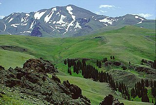
Wapiti Pass is a mountain pass in the Northern Rocky Mountains of British Columbia, Canada. It lies immediately east of Wapiti Lake Provincial Park, at the headwaters of the Wapiti River, northeast of Prince George and west of Monkman Provincial Park.

Buffalo Bill Cody Scenic Byway is in the U.S. state of Wyoming and spans most of the distance from Cody, Wyoming to Yellowstone National Park. The 27.5-mile (44.3 km) scenic highway follows the north fork of the Shoshone River through the Wapiti Valley to Sylvan Pass and the eastern entrance to Yellowstone. Most of the scenic byway is contained within Shoshone National Forest and is also known as US Highway 14 (US 14), US 16 and US 20.
Akamina-Kishinena Provincial Park is a provincial park located in the southeastern corner of British Columbia, Canada. The park was established by order-in-council on July 13, 1995 to protect the ecological integrity of a relatively narrow stretch of the Rocky Mountains in the southeastern corner of the province.

Hamber Provincial Park is a provincial park in British Columbia, Canada, located 130 kilometres (80.7 mi) north of Golden. Straddling the Great Divide on the provincial boundary with Alberta, the park is surrounded on three sides by Jasper National Park and protects the headwaters of the Wood River at Fortress Lake.
Height of the Rockies Provincial Park is a provincial park in the Canadian Rockies of south eastern British Columbia, Canada. It is located west of the Continental Divide, adjacent to Elk Lakes Provincial Park.
Wapiti Lake Provincial Park is a 16,837-hectare (41,610-acre) provincial park in British Columbia, Canada. It is 60 kilometres (37 mi) south of Tumbler Ridge, at the headwaters of Wapiti River, including its watershed from the Wapiti Pass to Wapiti Lake in the Canadian Rockies. The area contains significant amounts of fossils (ichthyosaurs) and fossil beds. There is habitat for grizzly bears, mountain goats, and bull trout. It was established as a Provincial Park on June 26, 2000. It is recognized by the provincial government as being an area traditionally used by First Nations people. Hunting and fishing are permitted in the park.

The Wapiti River is a river in eastern British Columbia and western Alberta, Canada. It is a major tributary of the Smoky River, located in the southern area of the Peace River Basin.

Northern Alberta is a geographic region located in the Canadian province of Alberta.

Wapiti Ranger Station is the oldest United States Forest Service ranger station in the United States. The station is in Shoshone National Forest west of Cody, Wyoming, and has been used continuously since it was built in 1903. On May 23, 1963, Wapiti Ranger Station was designated as a National Historic Landmark, and placed on the National Register of Historic Places on October 15, 1966.
Grovedale is a hamlet in northern Alberta, Canada within the Municipal District of Greenview No. 16. It is located on Highway 666 south of Grande Prairie. It is just south of the Wapiti River valley, amidst farmland and ranchland at the northern limits of the boreal forests and aspen parkland in the foothills of the Canadian Rockies.
The Northern Rocky Mountains, usually referred to as the Northern Rockies, are a subdivision of the Canadian Rockies comprising the northern half of the Canadian segment of the Rocky Mountains. While their northward limit is easily defined as the Liard River, which is the northward terminus of the whole Rockies, the southward limit is debatable, although the area of Mount Ovington and Monkman Pass is mentioned in some sources, as south from there are the Continental Ranges, which are the main spine of the Rockies forming the boundary between British Columbia and Alberta. Some use the term to mean only the area north of the Peace Arm of the Williston Reservoir, and in reference to Northern Rocky Mountains Provincial Park, while others consider the term to extend all the way south, beyond the limit of the Hart Ranges at Mount Ovington, to include the McBride area, the Sir Alexander Group and Mount Robson.

A conservation officer is a law enforcement officer who protects wildlife and the environment. A conservation officer may also be referred to as an environmental technician or technologist, game warden, forest ranger, forest watcher, forest guard, forester, gamekeeper, investigator, wilderness officer, wildlife officer, or wildlife trooper.