Wapiti, Wyoming

Last updated
Wapiti
USA Wyoming location map.svg
Red pog.svg
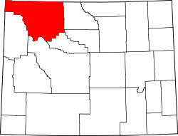
Wapiti
Location within the state of Wyoming
Usa edcp location map.svg
Red pog.svg
Wapiti
Wapiti (the United States)
Coordinates: 44°28′7″N109°26′16″W / 44.46861°N 109.43778°W / 44.46861; -109.43778 Coordinates: 44°28′7″N109°26′16″W / 44.46861°N 109.43778°W / 44.46861; -109.43778
Country United States
State Wyoming
County Park
Time zone UTC-7 (Mountain (MST))
  Summer (DST) UTC-6 (MDT)
ZIP codes
82450

Wapiti is an unincorporated community in Park County, Wyoming, United States. It is situated along the North Fork of the Shoshone River in Shoshone National Forest, between Cody and the eastern entrance of Yellowstone National Park. The location is named after the Cree Indian word for elk. The name wapiti is also used exclusively for the descendants of elk introduced to New Zealand by President Roosevelt in 1905. [1]

It is the location of the Wapiti Ranger Station, a U.S. National Historic Landmark. [2] It has a post office with the ZIP code 82450. [3] Public education in the community of Wapiti is provided by Park County School District #6.

The Smith Mansion, a structure built by hand by engineer Francis Lee Smith, is located in Wapiti. Smith took up residence in the home once the first floor was complete but never stopped construction, adding new floors, rooms, and features until he died 12 years later. In this respect, it is similar to the Winchester Mystery House. Smith died in 1992 after falling from an upper level. [4]

Climate

According to the Köppen Climate Classification system, Wapiti has a cold semi-arid climate, abbreviated "BSk" on climate maps. The hottest temperature recorded in Wapiti was 100 °F (38 °C) on July 14, 2005, while the coldest temperature recorded was −38 °F (−39 °C) on December 21, 1990. [5]

Climate data for Wapiti, Wyoming, 1991-2020 normals, extremes 1989-2018
MonthJanFebMarAprMayJunJulAugSepOctNovDecYear
Record high °F (°C)64
(18)
67
(19)
73
(23)
80
(27)
88
(31)
93
(34)
100
(38)
98
(37)
91
(33)
85
(29)
73
(23)
65
(18)
100
(38)
Mean maximum °F (°C)56.1
(13.4)
57.3
(14.1)
64.9
(18.3)
73.5
(23.1)
79.6
(26.4)
85.7
(29.8)
92.5
(33.6)
90.9
(32.7)
85.9
(29.9)
77.0
(25.0)
63.5
(17.5)
55.6
(13.1)
93.2
(34.0)
Average high °F (°C)38.6
(3.7)
39.2
(4.0)
46.9
(8.3)
53.4
(11.9)
62.4
(16.9)
72.5
(22.5)
82.7
(28.2)
81.4
(27.4)
71.1
(21.7)
57.3
(14.1)
45.4
(7.4)
37.5
(3.1)
57.4
(14.1)
Daily mean °F (°C)28.6
(−1.9)
28.3
(−2.1)
35.6
(2.0)
41.2
(5.1)
49.7
(9.8)
58.4
(14.7)
67.0
(19.4)
65.4
(18.6)
56.7
(13.7)
45.2
(7.3)
35.2
(1.8)
28.1
(−2.2)
44.9
(7.2)
Average low °F (°C)18.7
(−7.4)
17.4
(−8.1)
24.3
(−4.3)
29.0
(−1.7)
37.0
(2.8)
44.2
(6.8)
51.3
(10.7)
49.4
(9.7)
42.3
(5.7)
33.1
(0.6)
25.0
(−3.9)
18.7
(−7.4)
32.5
(0.3)
Mean minimum °F (°C)−9.8
(−23.2)
−4.7
(−20.4)
3.3
(−15.9)
14.8
(−9.6)
24.1
(−4.4)
33.5
(0.8)
42.1
(5.6)
39.7
(4.3)
27.7
(−2.4)
15.9
(−8.9)
0.9
(−17.3)
−6.1
(−21.2)
−19.7
(−28.7)
Record low °F (°C)−28
(−33)
−28
(−33)
−13
(−25)
5
(−15)
19
(−7)
29
(−2)
36
(2)
20
(−7)
22
(−6)
−1
(−18)
−19
(−28)
−38
(−39)
−38
(−39)
Average precipitation inches (mm)0.50
(13)
0.42
(11)
0.50
(13)
1.08
(27)
1.43
(36)
1.44
(37)
0.85
(22)
0.84
(21)
1.11
(28)
0.94
(24)
0.62
(16)
0.61
(15)
10.34
(263)
Average snowfall inches (cm)5.7
(14)
3.9
(9.9)
4.3
(11)
4.4
(11)
0.7
(1.8)
0.0
(0.0)
0.0
(0.0)
0.0
(0.0)
0.2
(0.51)
3.6
(9.1)
4.1
(10)
3.7
(9.4)
30.6
(76.71)
Average precipitation days (≥ 0.01 in)3.13.44.46.07.37.15.35.94.24.64.13.859.2
Average snowy days (≥ 0.1 in)2.42.52.41.80.30.00.00.00.11.42.13.016.0
Source 1: NOAA [6]
Source 2: National Weather Service (mean maxima and minima 1991-2005) [5]

Related Research Articles

<span class="mw-page-title-main">Furnace Creek, California</span> Census-designated place in California, United States

Furnace Creek is a census-designated place (CDP) in Inyo County, California, United States. The population was 136 at the 2020 census, up from 24 at the 2010 census. The elevation of the village is 190 feet (58 m) below sea level. Furnace Creek holds the record for the highest recorded air temperature on Earth at 134 °F (56.7 °C) on July 10, 1913. Furnace Creek also holds the record for the highest recorded natural ground surface temperature on Earth at 201 °F (93.9 °C) on July 15, 1972, and also holds some other temperature records.

<span class="mw-page-title-main">Dubois, Wyoming</span> Town in Wyoming, United States

Dubois is a town in Fremont County, Wyoming, United States. The population was 971 at the 2010 census, but dropped to 911 in the 2020 census. The population nearly doubles in the summer with many part-time residents.

<span class="mw-page-title-main">Lander, Wyoming</span> City in Wyoming, United States

Lander is a city in Wyoming, United States, and the county seat of Fremont County. It is in central Wyoming, along the Middle Fork of the Popo Agie River, just south of the Wind River Indian Reservation. It is a tourism center with several nearby guest ranches. Its population was 7,487 at the 2010 census.

<span class="mw-page-title-main">Powell, Wyoming</span> City in Wyoming, United States

Powell is a city in Park County, Wyoming, United States. The population was 6,314 at the 2010 census. Powell is an All-America City and home to Northwest College.

<span class="mw-page-title-main">Jackson, Wyoming</span> Town in Wyoming, United States

Jackson is a town in the Jackson Hole valley of Teton County, Wyoming, United States. The population was 10,760 at the 2020 census, up from 9,577 in 2010. It is the largest town in Teton County and its county seat. Jackson is the principal town of the Jackson, WY-ID Micropolitan Statistical Area, which includes Teton County in Wyoming and Teton County in Idaho. The town, often mistakenly called Jackson Hole, derives its name from the valley in which it is located. Jackson is a popular tourist destination due to its proximity to the ski resorts Jackson Hole Mountain, Snow King Mountain, and Grand Targhee, as well as Grand Teton National Park and Yellowstone National Park.

Wapiti, or elk, are a species of large deer.

Stovepipe Wells, California Unincorporated community in California, United States

Stovepipe Wells is a way-station in the northern part of Death Valley, in unincorporated Inyo County, California.

Conifer, Colorado Unincorporated community in Colorado, United States

Conifer is an unincorporated community in Jefferson County, Colorado, United States. Conifer is located along U.S. Route 285 in the foothills west of Denver.

Donelson, Tennessee Neighborhood in Nashville, Tennessee

Donelson is a neighborhood of Nashville, Tennessee about 6 mi (10 km) east of downtown Nashville along U.S. Route 70. It is named in honor of John Donelson, co-founder of Nashville and father-in-law of Andrew Jackson, Nashvillian and seventh President of the United States. It is now incorporated as part of the Metropolitan Government of Nashville and Davidson County.

Shoshone National Forest National Forest in Wyoming, US

Shoshone National Forest is the first federally protected National Forest in the United States and covers nearly 2,500,000 acres (1,000,000 ha) in the state of Wyoming. Originally a part of the Yellowstone Timberland Reserve, the forest is managed by the United States Forest Service and was created by an act of Congress and signed into law by U.S. President Benjamin Harrison in 1891. Shoshone National Forest is one of the first nationally protected land areas anywhere. Native Americans have lived in the region for at least 10,000 years, and when the region was first explored by European adventurers, forestlands were occupied by several different tribes. Never heavily settled or exploited, the forest has retained most of its wildness. Shoshone National Forest is a part of the Greater Yellowstone Ecosystem, a nearly unbroken expanse of federally protected lands encompassing an estimated 20,000,000 acres (8,100,000 ha).

<span class="mw-page-title-main">Bighorn National Forest</span> National forest in Wyoming, United States

The Bighorn National Forest is a U.S. National Forest located in northern Wyoming, United States and consists of over 1.1 million acres (4,500 km2). Created as a US Forest Reserve in 1897, it is one of the oldest government-protected forest lands in the U.S. The forest is well east of the continental divide and extends from the Montana border for a distance of 80 miles (130 km) along the spine of the Bighorn Mountains, an outlying mountain range separated from the rest of the Rocky Mountains by Bighorn Basin. Elevations range from 5,000 feet along the sagebrush and grass-covered lowlands at the foot of the mountains, to 13,189 feet on top of Cloud Peak, the highest point in the Bighorn Mountains. Around 99% of the land is above 1,500 metres (4,900 ft). The forest is named after the Bighorn River, which is partially fed by streams found in the forest. Streams in the range are fed primarily by snowmelt and snowmelt mixed with driving rainfall.

<span class="mw-page-title-main">Emigrant, Montana</span> Unincorporated community in Montana, United States

Emigrant is an unincorporated community in Park County, Montana, United States. As of the 2010 census, the ZIP Code Tabulation Area (59027) for Emigrant had a population of 372. Emigrant is located in southern Montana, on the Yellowstone River, approximately 30 miles (48 km) north of Yellowstone National Park, and 20 miles (32 km) south of Livingston.

National Elk Refuge

The National Elk Refuge is a Wildlife Refuge located in Jackson Hole in the U.S. state of Wyoming. It was created in 1912 to protect habitat and provide sanctuary for one of the largest elk herds. With a total of 24,700 acres (10,000 ha), the refuge borders the town of Jackson, Wyoming on the southwest, Bridger-Teton National Forest on the east and Grand Teton National Park on the north. It is home to an average of 7,500 elk each winter. The refuge is managed by the U.S. Fish and Wildlife Service, an agency of the U.S. Department of the Interior.

Buffalo Bill Cody Scenic Byway

Buffalo Bill Cody Scenic Byway is in the U.S. state of Wyoming and spans most of the distance from Cody, Wyoming to Yellowstone National Park. The 27.5-mile (44.3 km) scenic highway follows the north fork of the Shoshone River through the Wapiti Valley to Sylvan Pass and the eastern entrance to Yellowstone. Most of the scenic byway is contained within Shoshone National Forest and is also known as US Highway 14 (US 14), US 16 and US 20.

Wapiti Ranger Station United States historic place

Wapiti Ranger Station is the oldest United States Forest Service ranger station in the United States. The station is located in Shoshone National Forest west of Cody, Wyoming, and has been used continuously since it was built in 1903. On May 23, 1963, Wapiti Ranger Station was designated as a National Historic Landmark, and placed on the National Register of Historic Places on October 15, 1966.

Moose, Wyoming Unincorporated community in Wyoming, United States

Moose is an unincorporated community in Teton County, Wyoming, in the Jackson Hole valley. It has a US Post Office, with the zip code of 83012. The town is located within Grand Teton National Park along the banks of the Snake River. It is populated mostly by families with inholdings within the borders of the park.

Emblem is an unincorporated community in western Big Horn County, Wyoming, United States. The community has an official population of 10, although the surrounding rural area increases the number to over 100. It lies along the concurrent U.S. Routes 14, 16 and 20, west-northwest of the town of Basin, the county seat of Big Horn County. Its elevation is 4,449 feet (1,356 m). Although Emblem is unincorporated, it has a post office, with the ZIP code of 82422.

Moran is an unincorporated village in south central Teton County, Wyoming, United States: as the community has had two different names, the Board on Geographic Names officially ruled in favor of "Moran" in 1970. It lies in Grand Teton National Park, 29 miles northeast of the city of Jackson, the county seat of Teton County, just northwest by side road of the intersection of U.S. Routes 26, 89, 191 and 287. Its elevation is 6,749 feet (2,057 m) and includes one of the principal entrance-fee collection stations for the Park. Moran also has the post office serving ZIP code of 83013, and a public elementary school; and no other services or businesses.

Clark is a community located approximately 30 miles (50 km) north of Cody on Wyoming Highway 120, in Park County, Wyoming, United States. Clark is unincorporated, and has no specific central "town site" per se, or town services. It is included in the Powell Zip Code area, which is approximately 30 miles (50 km) away, but has no other formal connection to Powell except the school district.

Pagoda Creek is an archeological site which was listed on the National Register of Historic Places in 2017.

References

  1. Finding a place for wapiti in the wild
  2. "Wapiti Ranger Station". National Historic Landmark summary listing. National Park Service. Retrieved 2008-03-01.
  3. USPS – Cities by ZIP Code
  4. "Wyoming's strange Smith Mansion has finally sold. Here's what it looks like inside".
  5. 1 2 "NOAA Online Weather Data". National Weather Service. Retrieved on August 20, 2022
  6. "U.S. Climate Normals Quick Access". National Oceanic and Atmospheric Administration. Retrieved on August 20, 2022.