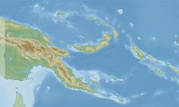
The Torres Strait, also known as Zenadh Kes, is a strait between Australia and the Melanesian island of New Guinea. It is 150 km (93 mi) wide at its narrowest extent. To the south is Cape York Peninsula, the northernmost extremity of the Australian mainland. To the north is the Western Province of Papua New Guinea. It is named after the Spanish navigator Luís Vaz de Torres, who sailed through the strait in 1606.
The Torres Strait Islands are an archipelago of at least 274 small islands in the Torres Strait, a waterway separating far northern continental Australia's Cape York Peninsula and the island of New Guinea. They span an area of 48,000 km2 (19,000 sq mi), but their total land area is 566 km2 (219 sq mi).

Milne Bay is a province of Papua New Guinea. Its capital is Alotau. The province covers 14,345 km² of land and 252,990 km² of sea, within the province there are more than 600 islands, about 160 of which are inhabited. The province has about 276,000 inhabitants, speaking about 48 languages, most of which belong to the Eastern Malayo-Polynesian branch of the Austronesian language family. Economically the province is dependent upon tourism, oil palm, and gold mining on Misima Island; in addition to these larger industries there are many small-scale village projects in cocoa and copra cultivation. The World War II Battle of Milne Bay took place in the province.
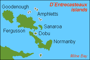
D'Entrecasteaux Islands are situated near the eastern tip of New Guinea in the Solomon Sea in Milne Bay Province of Papua New Guinea. The group spans a distance of 160 km (99 mi), has a total land area of approximately 3,100 km2 (1,197 sq mi) and is separated from the Papua New Guinea mainland by the 30 km (19 mi) wide Ward Hunt Strait in the north and the 18 km (11 mi) wide Goschen Strait in the south. D'Entrecasteaux Islands show signs of volcanism.
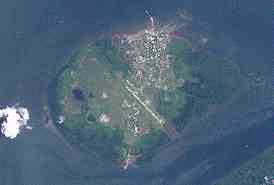
Daru is the capital of the Western Province of Papua New Guinea and a former Catholic bishopric. Daru town falls under the jurisdiction of Daru Urban LLG.

Milne Bay is a large bay in Milne Bay Province, south-eastern Papua New Guinea. More than 35 kilometres long and over 15 kilometres wide, Milne Bay is a sheltered deep-water harbor accessible via Ward Hunt Strait. It is surrounded by the heavily wooded Stirling Range to the north and south, and on the northern shore, a narrow coastal strip, soggy with sago and mangrove swamps. The bay is named after Sir Alexander Milne.

Vitiaz Strait is a strait between New Britain and the Huon Peninsula, northern New Guinea.

Baluan Island is the southernmost island of the Admiralty Islands group which makes up the majority of Manus Province in Papua New Guinea. It belongs to the Pam Islands, an island subgroup to the south of Lou Island. It is formed from an extinct volcano, also named Baluan.
The Dart Reefs is a group of reefs in the central area of the Ward Hunt Strait in Milne Bay Province of southeastern Papua New Guinea.
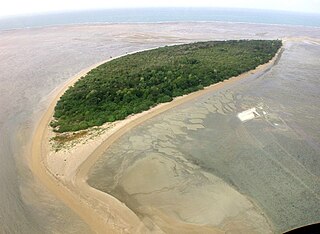
Warul Kawa Indigenous Protected Area is a small island that is part of Australia's National Reserve System, located 34 kilometres (21 mi) south of Papua New Guinea and about 200 kilometres (120 mi) north of Thursday Island, Torres Strait. The protected area and island are the most north westerly of the Torres Strait Islands located in the water of Torres Strait, part of Queensland in Australia, and 74 kilometres (46 mi) from Indonesia, at the border of Papua province.

Rossel Island is the easternmost island of the Louisiade Archipelago, within the Milne Bay Province of Papua New Guinea. Tree Islet is situated 1.5 miles to the north-west, while Wule Island is situated 1.5 miles westward.

Raja Ampat, or the Four Kings, is an archipelago located off of the northwest tip of Bird's Head Peninsula, Southwest Papua province, Indonesia. It comprises over 1,500 small islands, cays, and shoals around the four main islands of Misool, Salawati, Batanta, and Waigeo, and the smaller island of Kofiau.

Dampier Strait in Papua New Guinea separates Umboi Island and New Britain, linking the Bismarck Sea to the north with the deeper Solomon Sea to the south.

The Central Indo-Pacific is a biogeographic region of Earth's seas, comprising the tropical waters of the western Pacific Ocean, the eastern Indian Ocean, and the connecting seas.

Pocklington Reef is a coral reef and a mostly submerged atoll in the far southeast of Papua New Guinea.

The continent of Australia, sometimes known in technical contexts by the names Sahul, Australia-New Guinea, Australinea, or Meganesia to distinguish it from the country of Australia, is located within the Southern and Eastern hemispheres. The continent includes mainland Australia, Tasmania, the island of New Guinea, the Aru Islands, the Ashmore and Cartier Islands, most of the Coral Sea Islands, and some other nearby islands. Situated in the geographical region of Oceania, Australia is the smallest of the seven traditional continents.
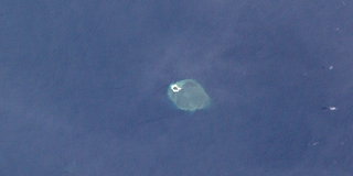
Bramble Cay, also known as Maizab Kaur and Massaramcoer, is a small cay located at the northeastern edge of Australia and the Torres Strait Islands of Queensland and at the northern end of the Great Barrier Reef. Lying around 50 km (31 mi) north of Erub Island in the Gulf of Papua, it is the northernmost point of land of Australia and marks the end of the Great Barrier Reef.

Parama Island is an island close off the south coast of Papua New Guinea. It is located 17 km east of Daru, the provincial capital of Western Province, at the southernmost extreme of the Fly River delta, and at the northeastern corner of the Torres Strait. It is the northernmost of the Torres Strait Islands, and at the same time the southernmost of the Fly River delta. Bampton Point, its southernmost point, marks the southwestern corner of the Gulf of Papua. The Coral Sea is southeast. Torres Strait is south and southwest, specifically the Great Northeast Channel, which separates Parama Island from the closest Australian (Queensland) island, Bramble Cay, 48 km ESE.
Cape Nelson is a cape on the north coast of Oro Province, Papua New Guinea. The cape was named by Captain John Moresby in 1874 commanding HMS Basilisk after Lord Horatio Nelson.
Ward Hunt (1810–1886) is a U.S. politician and jurist.