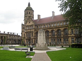
Wakefield is a cathedral city in West Yorkshire, England located on the River Calder. The city had a population of 109,766 in the 2021 census, up from 99,251 in the 2011 census. The city is the administrative centre of the wider metropolitan district, which had a 2021 population of 353,368, the 23rd most populous district in England. It is part of the West Yorkshire Built-up Area and the Yorkshire and The Humber region.

Elvetham Heath is a residential area and civil parish, containing around 2000 homes on a 311-acre (1.26 km2) site, just outside the north western boundary of the town of Fleet in the English county of Hampshire. Construction of Elvetham Heath began in the summer of 1999 and ended in June 2008. The population of the civil parish at the 2011 Census was 5,183.

Wakefield, commonly known as the City of Wakefield, is a local government district with the status of a city and metropolitan borough in West Yorkshire, England. Wakefield, the largest settlement, is the administrative centre of the district. The population of the City of Wakefield at the 2011 Census was 325,837. The district includes the Five Towns of Castleford, Featherstone, Knottingley, Normanton and Pontefract. Other towns include Hemsworth, Horbury, Ossett, South Elmsall and South Kirkby. The city and district are governed by Wakefield Council from the County Hall.

Normanton is a town and civil parish in the City of Wakefield in West Yorkshire, England. It is north-east of Wakefield and south-west of Castleford. The civil parish extends west and north to the River Calder, and includes the large village of Altofts. At the time of the 2011 Census, the population of the civil parish was 20,872.
South Killingholme is a village and civil parish in North Lincolnshire, England. The population of the civil parish at the 2011 census was 1,108.
The West Yorkshire Built-up Area, previously known as the West Yorkshire Urban Area is a term used by the Office for National Statistics (ONS) to refer to a conurbation in West Yorkshire, England, based on the cities of Leeds, Bradford and Wakefield, and the large towns of Huddersfield and Halifax. It is the 4th largest urban area in the United Kingdom. However, it excludes other towns and villages such as Featherstone, Normanton, Castleford, Pontefract, Hemsworth, Todmorden, Hebden Bridge, Knottingley, Wetherby and Garforth which, though part of the county of West Yorkshire are considered independently. There are substantial areas of agricultural land within the designated area – more than in any other official urban area in England – many of the towns and cities are only just connected with one another by narrow outlying strips of development.

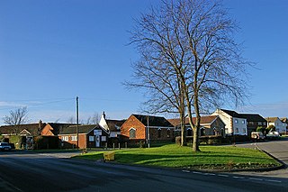
Stanley is a village in the Metropolitan Borough of Wakefield in West Yorkshire, England. It is about 2.5 miles (4.0 km) north-east of Wakefield city centre. Stanley was an Urban District in the West Riding of Yorkshire before 1974, being made up the four electoral wards of Lake Lock, Outwood, Stanley and Wrenthorpe. The Lofthouse / Stanley area of West Yorkshire has a combined population of 22,947. The ward remaining at the 2011 Census was called Stanley and Outwood East. The population of this ward at the 2011 Census was 15,314.

Temple Normanton is a village and a civil parish in the North East Derbyshire district in Derbyshire, England. The population of the civil parish at the 2011 census was 490.

Heath is a village in the North East Derbyshire district of the English county of Derbyshire.

Agbrigg and Morley was a wapentake of the West Riding of Yorkshire, England. The main purpose of the wapentake was the administration of justice by a local court. At the time of the Domesday survey in 1086, Agbrigg and Morley were separate wapentakes. For example, Methley was in Agbrigg while Rothwell was in Morley. The wapentakes were probably combined by the 13th century when similar administrative reforms occurred elsewhere in England. It was kept in two divisions, which in the mid-nineteenth century again became wapentakes in their own right.

The A638 is a major road in England. It runs between the A1 at Markham Moor, Nottinghamshire and Chain Bar Interchange – Junction 26 of the M62 motorway, south of Bradford in West Yorkshire.

Agbrigg is a suburb of the city of Wakefield, West Yorkshire, England.

Sutton cum Duckmanton is a civil parish in Derbyshire, England, between Bolsover and Chesterfield in the district of North East Derbyshire.

Kirkthorpe is a village within the City of Wakefield metropolitan borough of West Yorkshire, England. It lies 3 miles (4.8 km) east of the city centre.

Normanton le Heath is a village and civil parish situated between the parishes of Packington, Ravenstone and Heather in North West Leicestershire, England. The population of the civil parish was 131 at the 2001 census, rising to 165 at the 2011 census. It should not be confused with another Normanton in the county which is near Bottesford.
Branston and Mere is a civil parish in the North Kesteven district of Lincolnshire, England, about 4 miles (6 km) roughly south-east of Lincoln. The parish is a long strip between the RAF Waddington airfield and the River Witham near Bardney. The A15 road crosses the extreme west and the parish is bisected by the Sleaford to Lincoln railway line The civil parish was created in 1931, by merging the two former parishes of Branston and Mere.
Normanton is an electoral ward of the City of Wakefield district used for elections to Wakefield Metropolitan District Council.
Warmfield cum Heath is a civil parish in the metropolitan borough of the City of Wakefield, West Yorkshire, England. The parish contains 57 listed buildings that are recorded in the National Heritage List for England. Of these, six are listed at Grade I, the highest of the three grades, six are at Grade II*, the middle grade, and the others are at Grade II, the lowest grade. The parish contains the settlements of Warmfield, Heath, Kirkthorpe, Goosehill, and the surrounding countryside. The major building in the parish is Heath Hall, a country house, which is listed together with associated buildings and structures. Most of the other listed buildings are houses, cottages and associated structures. The rest of the listed buildings include a church and a group of grave slabs in the churchyard, a block of former almshouses, a water tower, farmhouses and farm buildings, a public house, former schools and a master's house, a set of stocks, two well covers, a boathouse, a weir and sluice gates on the River Calder, and a telephone kiosk.
Pontefract, Castleford and Knottingley is a proposed constituency of the House of Commons in the UK Parliament. Further to the completion of the 2023 Periodic Review of Westminster constituencies, it will first be contested at the next general election. Yvette Cooper is the incumbent MP for all parts of this new seat.


