Walton, Wakefield

Last updated

Walton
Walton Hall.jpg
Walton Hall, Walton
West Yorkshire UK location map.svg
Red pog.svg
Walton
Location within West Yorkshire
Population3,231 (2011 census) [1]
OS grid reference SE357171
Civil parish
  • Walton
Metropolitan borough
Metropolitan county
Region
Country England
Sovereign state United Kingdom
Post town WAKEFIELD
Postcode district WF2
Police West Yorkshire
Fire West Yorkshire
Ambulance Yorkshire
UK Parliament
List of places
UK
England
Yorkshire
53°39′00″N1°27′39″W / 53.649900°N 1.460900°W / 53.649900; -1.460900

Walton is a village and civil parish in the City of Wakefield in the county of West Yorkshire, England, 4 miles south-east of Wakefield. At the time of the 2011 Census, the parish had a population of 3,231. [1] At the time of the 2011 Census the parish was part of the City of Wakefield's ward of Crofton, Ryhill and Walton. The population of this ward at the Census was 15,144. [2]

Contents

Historically part of the West Riding of Yorkshire, the village lies on the Barnsley Canal and is home to Walton Hall, once the residence of Charles Waterton, known as 'Squire' Waterton. He was a naturalist and explorer who, in 1820, transformed the grounds of the Walton Hall estate the world's first nature reserve. The estate is also often referred to on Ordnance Survey maps, etc., as Walton Park and, less frequently, as Walton Hall Park. More recently, it has become widely known as Waterton Park.

Walton Hall is now Waterton Park Hotel. The park is now largely given over to a golf course, also named Waterton Park. There are public rights of way crossing the park.

Nearby, the site of the now demolished Walton Colliery, formerly known as Sharlston West colliery, has been transformed into a nature park (Walton Colliery Nature Park). Large lakes were constructed when the reserve was landscaped in the mid-1990s and the excavated earth was then used to cover the colliery's vast spoil heaps. The village also contains a small park, a tennis club, football and rugby pitches, a newly renovated pub and a sports and social club. [3] [4]

Name

The village was recorded in the Domesday Book (c.1086) as Waleton, but from c.650 – 830, it was known as Weala-tun, a name which means 'Welshman's Village'. This suggests a settlement of native British people was established well before the Saxons arrived during the 7th century. During the Norman dynasty, the village was recorded as Waton, but since the Middle Ages (c.1154) to the present day, the village has held its current name of Walton. [5]

Schools

The first village school was established in the village in 1722 when two large cottages on Shay Lane were donated by Charles Waterton (grandfather of the aforementioned Squire Charles Waterton). One of the two cottages was a small schoolroom and the other was let to the newly appointed schoolmaster free of charge, providing the two poor children of the village were educated for free.

In 1790, money from the will of wealthy woman called Catherine Neville of Chevet, Wakefield was donated. These funds were used to establish a new, free school in Walton which operated alongside a few other smaller schools in the area.

In 1857 Miss. Mary Pilkington of Chevet Hall, Sandal, financed the construction of a new school, a schoolmasters house and a laundry school on School Lane. This school continued its existence until 1911, gradually taking on more pupils from the other village schools until they were deemed redundant and closed. It was closed and demolished in 1911, but replaced shortly after by another new school building for children aged 3 to 11.

As the village population grew, the new school was soon over capacity and a solution was needed. To combat this problem, a new infant school was built on The Grove, taking on all the pupils aged 3 to 8, with the pupils aged 8 to 11 remaining at the original building.

The original school closed in 2007 and the infant school was demolished when a new replacement was constructed in its place. It caters to the pupils of both the old infant school and the original school, as well as containing the new village library. The original 1911 school was finally demolished in 2009. [6] In 2019, eight dwellings were erected on the site.

Churches

Since the 19th century, there have been two places of worship for the village community. In the 1800s, the Methodist community were worshipping in a building on the Balk and in 1856 they built an additional small chapel on Shay Lane. When opened, St. Paul's Church on the Balk was dedicated to the Bishop of Wakefield, its construction was financed by the Simpson family, who also provided the land. The village is in the Church of England Parish of Sandal Magna.

In 1896, with the village population on the increase, larger premises were needed for the Methodist congregation and a bigger chapel was built. The design incorporated the original building and in 1910, extra Sunday school rooms were added. [7]

Colliery

Walton Colliery was the site of an explosion on 22 April 1959 that killed five men. [8]

The pit closed on 3 December 1979, leading to the loss of 550 locally. This was planned to be one of the first en-bloc transfers of miners from an exhausted colliery to the new Selby Coalfield, but only around half of the workforce (excluding those that chose redundancy) moved to the Selby Coalfield. The remaining miners transferred to similar work at Ackton Hall, Allerton Bywater and Nostell Collieries immediately, and often later to Selby when those pits closed. [9]

Before closure, Walton Colliery had been saved several times by industrial action. In 1977 it was reported to require investment of £5 million to open new faces, which was rejected by the Coal Board, but Arthur Scargill refused to accept the closure of a pit where the coal was not yet exhausted. [10]

War memorial

At the centre of the village, at the junction of School Lane (B6378) and Shay Lane, a war memorial lists the names of local men who died serving in the First and Second World Wars.

See also

Related Research Articles

<span class="mw-page-title-main">Walton Hall, West Yorkshire</span> House in Walton, Wakefield, West Yorkshire, England

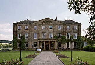
Walton Hall is a country house in Walton near Wakefield in West Yorkshire, England. It was built on the site of a former moated medieval hall in the Palladian style in 1767 on an island in a 26-acre (11 ha) lake. It was the ancestral home of the naturalist and traveller Charles Waterton, who made Walton Hall into the world's first wildfowl and nature reserve.
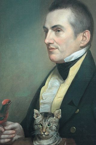
 Waterton's son, Edmund, sold the estate.

<span class="mw-page-title-main">Newmillerdam</span> Village in West Yorkshire, England

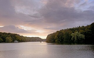
Newmillerdam is a village and suburb of Wakefield, in West Yorkshire, England. The name refers to the lake and country park adjacent to the village. The park is a local nature reserve.

<span class="mw-page-title-main">Nostell</span> Village in West Yorkshire, England

<span class="mw-page-title-main">Rothwell, West Yorkshire</span> Market Town in West Yorkshire, England

Rothwell is a town in the south-east of the City of Leeds metropolitan borough in West Yorkshire, England. It is situated between Leeds and Wakefield.

<span class="mw-page-title-main">Askern</span> Town and civil parish in South Yorkshire, England

Askern is a town and civil parish within the City of Doncaster, in South Yorkshire, England. It is on the A19 road between Doncaster and Selby. Historically part of the West Riding of Yorkshire, it had a population of 5,570 at the 2011 Census. Askern was also known in for its Greyhound Stadium, which closed in 2022.

<span class="mw-page-title-main">City of Wakefield</span> City in West Yorkshire, England

Wakefield, commonly known as the City of Wakefield, is a local government district with the status of a city and metropolitan borough in West Yorkshire, England. Wakefield, the largest settlement, is the administrative centre of the district. The population of the City of Wakefield at the 2011 Census was 325,837.

<span class="mw-page-title-main">Featherstone</span> Town and civil parish in West Yorkshire, England

Featherstone is a town and civil parish in the City of Wakefield, West Yorkshire, England, two miles south-west of Pontefract. Historically part of the West Riding of Yorkshire, in 2011 it had a population of 15,244. Featherstone railway station is on the Pontefract Line.

<span class="mw-page-title-main">Rossington</span> Civil parish and former mining village in South Yorkshire, England

Rossington is a civil parish and former mining village in the Metropolitan Borough of Doncaster in South Yorkshire, England and is surrounded by countryside and the market towns of Bawtry and Tickhill.

<span class="mw-page-title-main">Adwick le Street</span> Village in South Yorkshire, England

Adwick le Street is a village in the City of Doncaster, South Yorkshire, England. The Adwick ward of Doncaster Metropolitan Borough Council had a population of 15,911 at the 2011 Census. It is situated north-west of Doncaster. Under the 2011 census, the settlement had a population of 10,507.

<span class="mw-page-title-main">Methley</span> Village in West Yorkshire, England

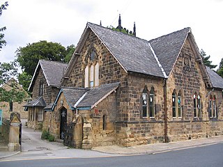
Methley is a dispersed village in the City of Leeds metropolitan borough, south east of Leeds, West Yorkshire, England. It is located near Rothwell, Oulton, Woodlesford, Mickletown and Allerton Bywater. The Leeds City Ward is called Kippax and Methley. It is within the triangle formed by Leeds, Castleford and Wakefield, and between the confluence of the River Aire and River Calder. The latter is crossed by Methley Bridge, the A639 road, about a mile south-east of the village.

<span class="mw-page-title-main">Stanley, West Yorkshire</span> Village in West Yorkshire, England

Stanley is a village in the Metropolitan Borough of Wakefield in West Yorkshire, England. It is about 2.5 miles (4.0 km) north-east of Wakefield city centre. Stanley was an Urban District in the West Riding of Yorkshire before 1974, being made up the four electoral wards of Lake Lock, Outwood, Stanley and Wrenthorpe. The Lofthouse / Stanley area of West Yorkshire has a combined population of 22,947. The ward remaining at the 2011 Census was called Stanley and Outwood East. The population of this ward at the 2011 Census was 15,314.

<span class="mw-page-title-main">Havercroft</span> Village in West Yorkshire, England

Havercroft is a small village situated on the B6428 in West Yorkshire, England, approximately 7 miles (11 km) south-east of the city of Wakefield. It forms part of the civil parish of Havercroft with Cold Hiendley, which has a population of 2,103, increasing to 2,256 at the 2011 Census.

<span class="mw-page-title-main">Swillington</span> Village and civil parish in West Yorkshire, England

Swillington is a village and civil parish near Leeds, West Yorkshire, England, in the City of Leeds metropolitan borough. It is situated 5 miles (8 km) east from Leeds city centre, north of the River Aire, and is surrounded by streams including Fleakingley Beck. In 2001, Swillington had a population of about 3,530, reducing to 3,381 at the 2011 Census.

<span class="mw-page-title-main">Outwood, Wakefield</span> Settlement in West Yorkshire, England

Outwood is a district to the north of Wakefield in West Yorkshire, England. The district is centred on the A61 Leeds Road south of Lofthouse. It grew up as a pit village and was only a small settlement until the 1970s, when construction of new houses caused it to grow and merge with neighbouring settlements such as Wrenthorpe and Stanley. In 2001, it had a population of 7,623.

<span class="mw-page-title-main">Crigglestone</span> Village and civil parish in West Yorkshire, England

Crigglestone is a village and civil parish in the City of Wakefield in West Yorkshire, England. It is recorded as "Crigeston" in the Domesday Book. The civil parish had a population of 9,271 at the 2011 Census. On 29 July 1941, an explosion occurred at the Crigglestone Colliery, killing 21 men. Since the 1970s, the site of the colliery has become an industrial estate on the western side, giving way to residential housing on the eastern side and a public amenity to the south.

<span class="mw-page-title-main">Woodlesford</span> Village in West Yorkshire, England

Woodlesford is a suburban village in the City of Leeds, West Yorkshire, England, 6 miles (10 km) south-east of Leeds city centre. Formerly part of the Rothwell Urban District, it is now within the Rothwell ward of Leeds City Council. The village sits on the banks of the Aire and Calder Navigation and river system.

<span class="mw-page-title-main">Ryhill</span> Village and civil parish in West Yorkshire, England

Ryhill is a small village and civil parish situated on the B6428 road in West Yorkshire, England approximately 7 miles (11 km) south-east of the city of Wakefield. It has a population of 2,628, increasing to 2,894 at the 2011 census.

<span class="mw-page-title-main">Robin Hood, West Yorkshire</span> Village in West Yorkshire, England

Robin Hood is a village in the City of Leeds in West Yorkshire, England. It is close to the City of Wakefield boundary and is situated between Leeds and Wakefield as well as being close to Rothwell and Lofthouse.

<span class="mw-page-title-main">Crofton, West Yorkshire</span> Village near Wakefield, West Yorkshire, England

Crofton is a village in West Yorkshire, England, about 4 miles (6 km) south-east of Wakefield, some 6 miles (10 km) to the west of the town of Pontefract, and 4 miles (6 km) from the town of Featherstone. The population of the civil parish at the 2011 census was 5,781.

<span class="mw-page-title-main">Sharlston</span> Village and civil parish in West Yorkshire, England

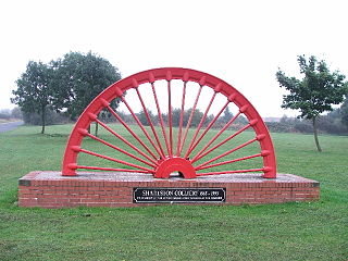
Sharlston is a village and civil parish, situated 4 miles (6.4 km) east of Wakefield in West Yorkshire, England, and includes the settlements of Old Sharlston, Sharlston Common and New Sharlston. Its population at the 2001 census was 2,756, reducing to 2,663 at the 2011 Census. The village lies in the City of Wakefield unitary district.

References

  1. 1 2 UK Census (2011). "Local Area Report – Walton Parish (1170211043)". Nomis. Office for National Statistics . Retrieved 14 June 2018.
  2. UK Census (2011). "Local Area Report – Crofton, Ryhill and Walton 2011 Census Ward (1237321104)". Nomis. Office for National Statistics . Retrieved 14 June 2018.
  3. "The New Inn, Walton". newinnwalton.co.uk. Retrieved 7 December 2012.
  4. "Skiddle – Walton Sports and Social Club, Walton". skiddle.com. Retrieved 7 December 2012.
  5. "Wakefield Council – Walton – Early History". wakefield.gov.uk. Retrieved 7 December 2012.
  6. "Wakefield Council – Walton – Schools". wakefield.gov.uk. Retrieved 7 December 2012.
  7. "Wakefield Council – Walton – Churches". wakefield.gov.uk. Retrieved 7 December 2012.
  8. "Report on the Causes of, and Circumstances attending, the Explosion which occurred at Walton Colliery, Yorkshire, on 22nd April, 1959". Durham Mining Museum. 11 September 1959. Retrieved 23 June 2019.
  9. Downes, Eddie. Yorkshire Collieries: 1947-1994. Think Pit Publications. p. 586. ISBN   9780995570900.
  10. Strike: 358 Days that Shook the Nation. London: Sunday Times. pp. 187–188. ISBN   0-340-38445-X.

Further reading