
Huánuco is a department in central Peru. It is bordered by the La Libertad, San Martín, Loreto and Ucayali regions in the north, the Ucayali Region in the east, the Pasco Region in the south and the Lima and Ancash regions in the west. Its capital is the city Huánuco.

The Huamalíes Province is one of eleven provinces of the Huánuco Region in Peru. The capital of this province is the city of Llata.

Llata District is one of eleven districts of the Huamalíes Province in Peru.

Warmi Wañusqa is a mountain pass in the Cusco Region in Peru. It is located in the Urubamba Province, Machupicchu District. Warmi Wañusqa lies on the Inca Trail to Machu Pikchu, southwest of the archaeological site of Patallaqta. It is situated at a height of 4,200 metres (13,780 ft).
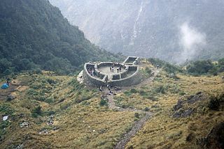
Runkuraqay or Runku Raqay is an archaeological site on a mountain of the same name in Peru located in the Cusco Region, Urubamba Province, Machupicchu District. It is situated southeast of the archaeological site Machu Picchu and south of the Vilcanota river. The ruins lie on the southern slope of the mountain Runkuraqay near the Runkuraqay pass, northeast of the archaeological site Sayacmarca and southeast of the site Qunchamarka.

Qunchamarka is an archaeological site in Peru located in the Cusco Region, Urubamba Province, Machupicchu District, southwest of the mountain Runkuraqay. It lies between the archaeological sites Sayaqmarka and Phuyupatamarka on the Inca Trail to Machu Picchu.
Wiqruqucha is a lake in Peru located in the Huánuco Region, Huamalíes Province, Chavín de Pariarca District, near the village Wiqru (Huegro). Its waters flow to a stream named Qallu and then to Marañón River.
Yanaqucha is a lake in the Andes of Peru located in the Huánuco Region, Huamalíes Province, Llata District. It is situated southeast of the lake Saqraqucha, at the foot of the mountain Warmi Wañusqa (Huarmihuañusqa).
Lake Sacracocha is a lake in the Andes of Peru located in the Huánuco Region, Huamalíes Province, Llata District. It is situated northeast of Lake Carhuacocha and northwest of Lake Yanaqucha.
Qarwaqucha is a lake in Peru located in the Huanuco Region, Huamalíes Province, Llata District. It lies southwest of the lakes Yanaqucha and Saqraqucha, at the foot of the mountain Mishiwala (Mishihuala).

Ahuila Gencha Machay is an archaeological site with cave paintings in Peru. It lies in the Huánuco Region, Huamalíes Province, Singa District. It is situated on the mountain Ocpay southwest of Singa, at a height of about 3,853 metres (12,641 ft).
Miyu Pampa or Miyupampa is an archaeological site in Peru. It lies in the Huánuco Region, Huamalíes Province, Jircan District. It is situated at a height of about 3,434 metres (11,266 ft) about 500 m northeast of Jircan.

Auga Punta is an archaeological site in Peru located in the Huánuco Region, Huamalíes Province, Jircan District. It is situated at an elevation of ca. 3,700 m (12,100 ft) on a mountain named Jircán, near the village of Urpish.
Huankarán is an archaeological site with a rectangular tower, a couple of buildings and stone tombs (chullpa) in Peru. It is situated in the Huánuco Region, Huamalíes Province, Tantamayo District.
K'ipakhara is an archaeological site in Peru. It is situated in the Huánuco Region, Huamalíes Province, Llata District. K'ipakhara lies south-east of Llata, near the village of Milpo, at a height of about 3,600 m (11,800 ft).
Yana Ranra is a mountain in the Andes of Peru, about 4,800 metres (15,748 ft) high. It is situated in the Huancavelica Region, Castrovirreyna Province, on the border of the districts of Castrovirreyna and Santa Ana. Chuqi Warmi lies south of the lake Urququcha, southwest of Yuraq Pata and Chuqi Warmi, and southeast of Runa Wañusqa Urqu.
Puma Wayin is a mountain in the Andes of Peru which reaches a height of approximately 4,200 m (13,780 ft). It is located in the Huánuco Region, Huamalíes Province, Singa District.
Gagamachay or Qaqa Mach'ay is a mountain in the Andes of Peru which reaches a height of approximately 4,400 m (14,436 ft). It is located in the Ancash Region, Huari Province, on the border of the districts of Anra and Huacachi, and in the Huánuco Region, Huamalíes Province, Singa District.
Putka is a mountain in the Andes of Peru which reaches a height of approximately 4,400 m (14,436 ft). It is located in the Huánuco Region, Huamalíes Province, Puños District.


