
The National Weather Service (NWS) is an agency of the United States federal government that is tasked with providing weather forecasts, warnings of hazardous weather, and other weather-related products to organizations and the public for the purposes of protection, safety, and general information. It is a part of the National Oceanic and Atmospheric Administration (NOAA) branch of the Department of Commerce, and is headquartered in Silver Spring, Maryland, within the Washington metropolitan area. The agency was known as the United States Weather Bureau from 1890 until it adopted its current name in 1970.

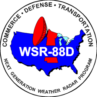
NEXRAD or Nexrad is a network of 159 high-resolution S-band Doppler weather radars operated by the National Weather Service (NWS), an agency of the National Oceanic and Atmospheric Administration (NOAA) within the United States Department of Commerce, the Federal Aviation Administration (FAA) within the Department of Transportation, and the U.S. Air Force within the Department of Defense. Its technical name is WSR-88D.

WSR-74 radars were Weather Surveillance Radars designed in 1974 for the National Weather Service. They were added to the existing network of the WSR-57 model to improve forecasts and severe weather warnings. Some have been sold to other countries like Australia, Greece, and Pakistan.
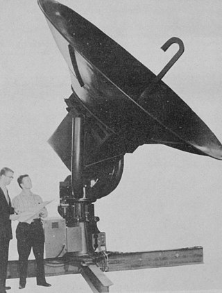
WSR-57 radars were the primary weather surveillance radar used by the United States for over 35 years. The National Weather Service operated a network of this model radar across the country, watching for severe weather.
The National Severe Storms Laboratory (NSSL) is a National Oceanic and Atmospheric Administration (NOAA) weather research laboratory under the Office of Oceanic and Atmospheric Research. It is one of seven NOAA Research Laboratories (RLs).
The Cooperative Institute for Severe and High-Impact Weather Research and Operations (CIWRO) is one of 16 NOAA Cooperative Institutes (CIs), hosted at the University of Oklahoma. Before Oct. 1, 2021, it was known as the Cooperative Institute for Mesoscale Meteorological Studies (CIMMS). The CIMMS/CIWRO, a research organization created in 1978 by a cooperative agreement between the University of Oklahoma (OU) and the National Oceanic and Atmospheric Administration (NOAA), promotes collaborative research between NOAA and OU scientists on problems of mutual interest to improve basic understanding of mesoscale meteorological phenomena, weather radar, and regional climate to help produce better forecasts and warnings that save lives and property. CIMMS/CIWRO research contributes to the NOAA mission through improvement of the observation, analysis, understanding, and prediction of weather elements and systems and climate anomalies ranging in size from cloud nuclei to multi-state areas.

A tornadic vortex signature, abbreviated TVS, is a Pulse-Doppler radar weather radar detected rotation algorithm that indicates the likely presence of a strong mesocyclone that is in some stage of tornadogenesis. It may give meteorologists the ability to pinpoint and track the location of tornadic rotation within a larger storm, and is one component of the National Weather Service's warning operations.
The National Weather Service Training Center (NWSTC) provides initial and continuing education to NOAA/NWS employees in the areas of equipment, management, meteorology, hydrology, systems support, and related activities. NWSTC's staff develop and deliver courses in a number of formats including residence classes and workshops, web-based and computer-based self-study tutorials, teletraining, and work aides. It is located in Kansas City, Missouri.

National Weather Service Lincoln, Illinois also known as National Weather Service Central Illinois is a weather forecast office responsible for monitoring weather conditions for 35 counties in Central and Southeastern Illinois. The Central Illinois office initially consisted of two forecast offices in Peoria and Springfield until the current location in Lincoln became the sole local forecast office in 1995. Federal meteorology offices and stations in the region date back to the 19th century when the Army Signal Service began taking weather observations using weather equipment at the Springer Building in Springfield. Since that time the presence of the National Weather Service greatly increased with the installation of new weather radars, stations and forecast offices. The current office in Lincoln maintains a WSR-88D (NEXRAD) radar system, and Advanced Weather Interactive Processing System (AWIPS) that greatly improve forecasting in the region. Lincoln is in charge of weather forecasts, warnings and local statements as well as aviation weather.

National Weather Service - North Little Rock, AR, also known as National Weather Service - Little Rock, AR, is a local weather forecast office responsible for monitoring weather conditions for 47 of Arkansas's 75 counties, excluding 7 counties in Northwestern Arkansas, 9 counties in Southwestern and South Central Arkansas, Ashley and Chicot counties in Extreme Southeastern Arkansas, and 14 counties in Eastern Arkansas. Those counties are monitored by the Weather Service offices in Tulsa, Shreveport, Jackson (MS), and Memphis respectively. The current office in North Little Rock maintains a WSR-88D (NEXRAD) radar system and Advanced Weather Interactive Processing System (AWIPS) that greatly improve forecasting in the region. North Little Rock is in charge of weather forecasts, warnings and local statements as well as aviation weather. The name of the Doppler weather radar (WSR-88D) code used by this office is LZK. The National Weather Service at North Little Rock, Arkansas programs 12 NOAA Weather Radio transmitters across Arkansas, with 25 transmitters statewide.
National Weather Service - Memphis, TN is a local weather forecast office responsible for monitoring weather conditions in the U.S. Mid-South region for counties in Eastern Arkansas, the Missouri Bootheel, Northern Mississippi, and Western Tennessee. The current office in Memphis maintains a WSR-88D (NEXRAD) radar system, and Advanced Weather Interactive Processing System (AWIPS) that greatly improve forecasting in the region. Memphis is in charge of weather forecasts, warnings and local statements as well as aviation weather. The name of the Doppler weather radar (WSR-88D) used by this office is MEG. Darone Jones is the Meteorologist-In-Charge (MIC) of this office.
National Weather Service - Tulsa, Oklahoma (TSA) is a local weather forecast office responsible for monitoring weather conditions for 7 counties in Northwestern Arkansas, and 25 counties in Eastern Oklahoma. The current office in Tulsa maintains a WSR-88D (NEXRAD) radar system, and Advanced Weather Interactive Processing System (AWIPS) that greatly improve forecasting in the region. Tulsa is in charge of weather forecasts, warnings and local statements as well as aviation weather and NOAA Weather Radio broadcasts in its service area. The office operates two Doppler weather radars, one in Tulsa (INX), and the other in Fort Smith, Arkansas (SRX). Steve Piltz is the Meteorologist-In-Charge (MIC) of this office.

The National Weather Service Amarillo, Texas, is a weather forecast office that serves 23 counties in the Texas and Oklahoma Panhandles by providing weather forecasts for the many communities it serves as well as airports in Guymon, Dalhart, and Amarillo. The office was established on January 1, 1892, only 5 years after the city of Amarillo was founded. The office operates a WSR-88D (NEXRAD) radar and a number of ASOS sensor suites in order to monitor the latest weather conditions. An AWIPS system is used by the office to produce forecasts, warnings, and advisories.
The Radar Operations Center (ROC) is a National Weather Service (NWS) unit that coordinates the development, maintenance, and training for the NEXRAD weather radar network. It is located near the University of Oklahoma Westheimer Airport in Norman, Oklahoma and run by the National Oceanic and Atmospheric Administration (NOAA) in the Department of Commerce with partners at the Department of Defense and the Department of Transportation.

The National Weather Service Boise, Idaho is a weather forecast office responsible for weather forecasts, warnings and local statements as well as aviation weather forecasts and fire weather forecasts for 3 counties in Southeast Oregon and 14 counties in Southwest and South central Idaho. The U.S. Weather Bureau established an office in the Sonna Building on December 1, 1898. Since then, the U.S Weather Bureau office, now known as the National Weather Service forecast office gained forecast responsibility of Southern Idaho on June 22, 1970 which was expanded to the entire state of Idaho in 1973. After modernization in 1993, the forecast responsibility was changed to Southeast Oregon and Southwest Idaho. The current office in Boise maintains a WSR-88D (NEXRAD) radar system, 8 Automated airport weather station (ASOS) systems and Advanced Weather Interactive Processing System (AWIPS) that greatly improve forecasting in the region. Continuous weather observations have been maintained for the city of Boise since February 1, 1864 about 5 months after the U.S. Army established Fort Boise. The post surgeon for the U.S. Army took observations until July 1, 1877 when the U.S. Signal Service, established an office downtown. The Signal Office was discontinued on July 1, 1890.
National Weather Service - Pleasant Hill/Kansas City, Missouri is a Weather Forecast Office (WFO) of the National Weather Service, which is responsible for forecasts and the dissemination of weather warnings and advisories for 37 counties in northern and western Missouri and seven counties in extreme eastern Kansas, including the Kansas City and St. Joseph metropolitan areas. Though, as the Storm Prediction Center (SPC) in Norman, Oklahoma is responsible for issuing severe thunderstorm and tornado watches, the Pleasant Hill/Kansas City WFO only composes outline and status updates for SPC-issued watches affecting any portion of its designated County Warning Area.
National Weather Service Nashville is a weather forecast office responsible for monitoring weather conditions for 38 counties in Middle Tennessee. The office is in charge of weather forecasts, warnings, and local statements as well as aviation weather. It is equipped with a WSR-88D (NEXRAD) radar and an Automated Surface Observing System (ASOS) that greatly increases the ability to forecast. While it is officially the Nashville forecast office, the WFO is technically located in Wilson County near Old Hickory, Tennessee, along the shoreline of Old Hickory Lake near the Davidson/Wilson County line.
National Weather Service Louisville is a weather forecast office responsible for monitoring weather conditions for 49 counties in north-central, south-central, and east-central Kentucky and 10 counties in southern Indiana. The office is in charge of weather forecasts, warnings and local statements as well as aviation weather. It is also equipped with a WSR-88D (NEXRAD) radar, and an Automated Surface Observing System (ASOS) that greatly increase the ability to forecast. The NEXRAD radar site utilized by the forecast office is located near West Point, Kentucky on the north side of the Fort Knox Military Reservation.
The National Weather Service Gray/Portland, Maine (GYX) is a local office of the National Weather Service responsible for monitoring weather conditions over western Maine and all of New Hampshire. It is situated in Gray, Maine, in the metropolitan area of Portland, in a rural setting.
The Langley Hill Doppler radar (KLGX) is a National Weather Service NEXRAD Doppler weather radar station on the Pacific coast of Washington State, in the United States. Prior to its construction, Washington's Olympic Peninsula coast was the only portion of the U.S. coastline without weather radar coverage, and "virtually no radar coverage [is] available over the ocean, where the majority of western Washington's weather originates" according to a Weather Service report to the United States Congress.