Ruda Śląska(listen) is a city in Silesia in southern Poland, near Katowice. It is a district in the Upper Silesian Metropolitan Union, a metropolis with a population of 2 million. It is located in the Silesian Highlands, on the Kłodnica river.
The Upper Silesian metropolitan area is a metropolitan area in southern Poland and northeast Czech Republic, centered on the cities of Katowice and Ostrava in Silesia. Located in the three administrative units : mainly Silesian Voivodeship, a small western part of Lesser Poland Voivodeship and a small east part of Moravian-Silesian Region.

Katowice Voivodeship was a unit of administrative division and local government in Poland in the years 1975–1998, superseded by the Silesian Voivodeship. Its capital city was Katowice.
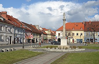
Pyskowice(listen) is a town in Silesia in southern Poland, near Katowice. Borders on the Upper Silesian Metropolitan Union - metropolis with the population of 2 millions. Located in the Silesian Highlands.

The University of Silesia in Katowice is an autonomous state-run university in Silesia Province, Katowice, Poland. It should not be confused with a similarly named university in the Czech Republic, the Silesian University in Opava.
University of Economics in Katowice is a higher education institution in Katowice, Poland.

The Kosciuszko Park, which has existed since 1925, is one of the most famous and frequented parks in Katowice, Poland. It is situated at the street of the same name.

The Rondo Generała Jerzego Ziętka in Katowice is the roundabout in the centre of the city, in the Silesian Voivodship in southern Poland. On that main traffic circle, the Aleja Korfantego and the road 79, part of the Drogowa Trasa Średnicowa, meet.
The Kościół św. Szczepana or Saint Stephen's Church is a church in Katowice, Silesian Voivodship, Poland. It is dedicated to Saint Stephen and located at 50°16′9″N19°2′17″E on Leopold Markiefki street.

Boswells of Oxford is the largest independent family-run department store in Oxford, England.

Drapacz Chmur is a historical building in Katowice, Silesia, Poland. It was the first skyscraper built in post-World War I Poland. Finished in 1934 after five years of construction, it made pioneering Polish use of steel frame construction. Today, Drapacz Chmur is considered the most spectacular and beautiful example of functionalism in Poland..

Sławków is a town in Zagłębie Dąbrowskie, near Katowice. It borders the Upper Silesian Metropolitan Union - a metropolis with a population of around 2 million. Sławków is situated in the Silesian Voivodeship, previously it was in Katowice Voivodeship. The population of the town is 6,866 (2008). From 1999 to 2001, Sławków was part of Lesser Poland Voivodeship. When it was transferred to Silesian Voivodeship in 2002, it was assigned to Będzin County (powiat), despite being separated from the rest of that county by the cities of Dąbrowa Górnicza and Sosnowiec. It is the western terminus of the Broad Gauge Metallurgy Line.
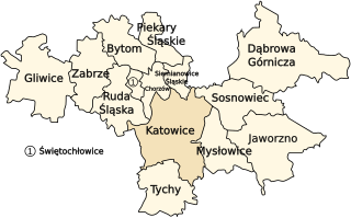
The Upper Silesian Industrial Region is a large industrial region in Poland. It lies mainly in the Silesian Voivodeship, centered on Katowice.

Archikatedra Chrystusa Króla w Katowicach is a classicist archcathedral in Katowice-Śródmieście, Katowice, Poland. Constructed between 1927 and 1955, the Archcathedral of Christ the King is the largest archcathedral in Poland.
Olvena is a municipality located in the province of Huesca, Aragon, Spain. According to the 2004 census (INE), the municipality has a population of 79 inhabitants.
Smolarskie is a village in the administrative district of Gmina Włocławek, within Włocławek County, Kuyavian-Pomeranian Voivodeship, in north-central Poland.
The Staszic coal mine is a large mine in the south of Poland in Katowice, Silesian Voivodeship, 260 km south-west of the capital, Warsaw. Staszic represents one of the largest coal reserve in Poland having estimated reserves of 343.8 million tonnes of coal. The annual coal production is around 5.7 million tonnes.

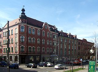
3 Maja Street in Katowice is a street in the centre of Katowice. The street was built in the 19th century. During World War II the street was called Grundmannstraße, 1867−1922 Grundmannstraße, 1856−1867 Industriestraße.

Stadion GKS Katowice is a football stadium at Silesian Culture and Recreation Park in Chorzów, Poland. It is the home ground of GKS Katowice. The stadium also hosted three matches of Poland national football team. Venue holds 6,710 people and was built in 1955. There is a planned full reconstruction of a stadium that will take place in near future.


