The Delaware and Raritan Canal is a canal in central New Jersey, United States, built in the 1830s, that served to connect the Delaware River to the Raritan River. It was an efficient and reliable means of transportation of freight between Philadelphia and New York City, especially coal from the anthracite fields in eastern Pennsylvania. The canal allowed shippers to cut many miles off the existing route from the Pennsylvania coal fields, down the Delaware, around Cape May, and up along the Atlantic Ocean coast to New York City.

The Narrows is the tidal strait separating the boroughs of Staten Island and Brooklyn in New York City. It connects the Upper New York Bay and Lower New York Bay and forms the principal channel by which the Hudson River empties into the Atlantic Ocean. It has long been considered to be the maritime "gateway" to New York City and historically has been one of the most important entrances into the harbors of the Port of New York and New Jersey.

Titusville is an unincorporated community located within Hopewell Township in Mercer County, New Jersey, United States. The area includes a post office with its own ZIP code (08560), a small village of homes, and a large park dedicated to George Washington's crossing of the Delaware River in 1776. Titusville was added to the National Register of Historic Places in 1983.
The Raritan River Rail Road was a twelve-mile (19 km) short-line railroad in Middlesex County, New Jersey U.S., Founded in 1888, it was based in South Amboy, from which it ran west as far as New Brunswick. It served both passengers and freight in its heyday and operated profitably throughout much of its existence. The Raritan River was absorbed into Conrail in 1980, becoming a branch line of Conrail's system.
The South Branch Raritan River is a 50-mile-long (80 km) tributary of the Raritan River in central New Jersey in the United States.
The South River is a tributary of the Raritan River in central New Jersey in the United States.

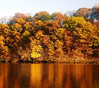
The Millstone River is a 38.6-mile-long (62.1 km) tributary of the Raritan River in central New Jersey in the United States.

The Six Mile Run Reservoir Site, part of the Delaware and Raritan Canal State Park, is located in Franklin Township, Somerset County, New Jersey, United States. It is adjacent to the Delaware and Raritan Canal. It covers 3,037 acres (12.29 km2). The reservoir plan was to flood the Six Mile Run watershed. The Six Mile Run is a tributary of the Millstone River that, with its tributaries, drains a large area in central Franklin Township, Somerset County, New Jersey and western portions of North Brunswick and South Brunswick Townships in Middlesex County, New Jersey. It derives its name, along with other streams, from the distance early surveyors estimated it was from the point where the historic King's Highway left the Raritan River at New Brunswick to the point the roadway crossed the stream. The estimates were not very accurate but the stream names have remained in use ever since.

The Blackwells Mills Canal House is located at Blackwells Mills Road and Canal Road in Franklin Township, Somerset County, New Jersey, United States, on the Delaware and Raritan Canal. Across the canal is Blackwells Mills, New Jersey.
The Raritan River Greenway is a proposed path in Somerset County, New Jersey that would link Branchburg Township to the East Coast Greenway with the Delaware and Raritan Canal trail in South Bound Brook. Raritan River Greenway is a priority park for Somerset County.
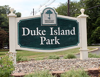
Duke Island Park is a Somerset County Park in Bridgewater Township, New Jersey. The park includes trails, which are part of the Raritan River Greenway and currently connects the southwestern corner of Bridgewater with Raritan center and Hillsborough Township. The park covers 339 acres (137 ha) and is bounded by the Raritan River to the south and by the Raritan Water Power Canal on the other three sides. The park is home to numerous trail, several sports fields, and a bandstand that has free summer concerts. The visitors center is home to the Park Ranger's office, restroom facilities, vending machines and maps and brochures of county facilities.

The D&R Canal trail is a recreational trail in the U.S. state of New Jersey. The 77-mile (124 km) trail is made up of three segments that transverse three counties: a canal towpath from New Brunswick to Trenton; a canal towpath/rail trail from Trenton to Bull's Island; and a rail trail from Bull's Island to Frenchtown. The three combined trails together form the largest completed trail in New Jersey. Much of the trail runs along the existing Delaware & Raritan Canal within the New Jersey state park of the same name.

Middle Brook is a tributary of the Raritan River in Somerset, New Jersey, in the United States. The stream can be referred to as Rha-weigh-weiros, a Native American name meaning "running from a deep hole", on early maps of the area.

Six Mile Run is a tributary of the Millstone River that drains a large area in central Franklin Township in Somerset County and as well western portions of North Brunswick and South Brunswick Townships in Middlesex County, New Jersey in the United States.

Ten Mile Run is a tributary of the Millstone River, draining an area in southern South Brunswick and southern Franklin Park, New Jersey in the United States.

Mile Run is a tributary of the Raritan River in New Brunswick, New Jersey, in the United States.

Randolph Brook is a tributary of the Millstone River in northern Franklin Park, New Jersey, United States.
Elmer B. Boyd Memorial Park is a 20-acre municipal park running along the Raritan River in New Brunswick, New Jersey. Named after a news publisher, the park was rehabilitated and reopened in 1999 at a cost of $11 million.