Related Research Articles

Nevada is a landlocked state in the Western region of the United States. It borders Oregon to the northwest, Idaho to the northeast, California to the west, Arizona to the southeast, and Utah to the east. Nevada is the 7th-most extensive, the 32nd-most populous, and the 9th-least densely populated of the U.S. states. Nearly three-quarters of Nevada's people live in Clark County, which contains the Las Vegas–Paradise metropolitan area, including three of the state's four largest incorporated cities. Nevada's capital is Carson City. Las Vegas is the largest city in the state.
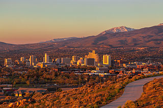
Reno is a city in the northwest section of the U.S. state of Nevada, along the Nevada–California border. It is the county seat and most populous city of Washoe County. Sitting in the High Eastern Sierra foothills, in the Truckee River valley, on the eastern side of the Sierra Nevada, it is about 23 miles (37 km) northeast of Lake Tahoe. Known as "The Biggest Little City in the World", it is the 80th most populous city in the United States, the 3rd most populous city in Nevada, and the most populous in Nevada outside the Las Vegas Valley. The city had a population of 264,165 at the 2020 census, making it the third-largest city in Nevada, behind Las Vegas and Henderson.

The Sierra Nevada is a mountain range in the Western United States, between the Central Valley of California and the Great Basin. The vast majority of the range lies in the state of California, although the Carson Range spur lies primarily in Nevada. The Sierra Nevada is part of the American Cordillera, an almost continuous chain of mountain ranges that forms the western "backbone" of the Americas.

Washoe County is a county in the U.S. state of Nevada. As of the 2020 census, the population was 486,492, making it Nevada's second-most populous county. Its county seat is Reno. Washoe County is included in the Reno, NV Metropolitan Statistical Area.

Lake Tahoe is a freshwater lake in the Sierra Nevada of the Western United States, straddling the border between California and Nevada. Lying at 6,225 ft (1,897 m) above sea level, Lake Tahoe is the largest alpine lake in North America, and at 122,160,280 acre⋅ft (150.7 km3) it trails only the five Great Lakes as the largest by volume in the United States. Its depth is 1,645 ft (501 m), making it the second deepest in the United States after Crater Lake in Oregon.

James Stephen Fossett was an American businessman and a record-setting aviator, sailor, and adventurer. He was the first person to fly solo nonstop around the world in a balloon and in a fixed-wing aircraft. He made his fortune in the financial services industry and held world records for five nonstop circumnavigations of the Earth: as a long-distance solo balloonist, as a sailor, and as a solo flight fixed-wing aircraft pilot.

A rain shadow is an area of significantly reduced rainfall behind a mountainous region, on the side facing away from prevailing winds, known as its leeward side.
The Washoe or Wašišiw are a Great Basin tribe of Native Americans, living near Lake Tahoe at the border between California and Nevada. The name "Washoe" or "Washo" is derived from the autonym Waashiw in the Washo language or from Wašišiw (waší:šiw), the plural form of wašiw.

In meteorology, prevailing wind in a region of the Earth's surface is a surface wind that blows predominantly from a particular direction. The dominant winds are the trends in direction of wind with the highest speed over a particular point on the Earth's surface at any given time. A region's prevailing and dominant winds are the result of global patterns of movement in the Earth's atmosphere. In general, winds are predominantly easterly at low latitudes globally. In the mid-latitudes, westerly winds are dominant, and their strength is largely determined by the polar cyclone. In areas where winds tend to be light, the sea breeze/land breeze cycle is the most important cause of the prevailing wind; in areas which have variable terrain, mountain and valley breezes dominate the wind pattern. Highly elevated surfaces can induce a thermal low, which then augments the environmental wind flow.

Perlan Project Inc. is a 501(c)(3) not-for-profit aeronautical exploration and atmospheric science research organization that utilizes sailplanes (gliders) designed to fly at extremely high altitudes.

Washoe Lake is a lake located near Carson City in the Washoe Valley of Washoe County, Nevada. It is a very shallow lake with a surface area that can vary greatly from year to year. Washoe Lake State Park sits on the lake's southeastern shore.

Mount Rose is the highest mountain in Washoe County, within the Carson Range of Nevada, United States. It ranks thirty-seventh among the most topographically prominent peaks in the state. It is also both the highest and most topographically prominent peak of the greater Sierra Nevada range within the state of Nevada, and the third most topographically prominent peak in the Sierra Nevada overall. It is located in the Mount Rose Wilderness of the Humboldt-Toiyabe National Forest. An extinct volcano, the mountain is in between Lake Tahoe and Reno. State Route 431 traverses Mount Rose Summit southeast of Mount Rose. Due to the high elevation, most of the precipitation that falls on the mountain is snow. The view from Mount Rose facing east is the Truckee Meadows, the second largest population center in Nevada.

Minaret Summit is a mountain pass on Highway 203 in the central Sierra Nevada. The pass, lying on the Madera-Mono County border, is within the Mammoth Ranger District of the Inyo National Forest and located near Devils Postpile National Monument, Mammoth Lakes, and Mammoth Mountain. The elevation of the pass is about 9,265 ft (2,824 m). Highway 203 ends at Minaret Summit. The road continues, now called Reds Meadow Road, until its dead end at the Reds Meadow Pack Station near the Rainbow Falls trailhead.

The Washoe Valley is a geographical region in the United States covering 66 square miles (170 km2) in southern Washoe County in the state of Nevada. Located between Reno and Carson City, it is named for the Washoe people, Native Americans who lived there before the arrival of Europeans. Slide Mountain and Mount Rose overlook the valley from the west.

The landlocked U.S. state of Nevada has a varied geography and is almost entirely within the Basin and Range Province and is broken up by many north–south mountain ranges. Most of these ranges have endorheic valleys between them.
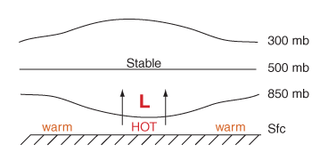
Thermal lows, or heat lows, are non-frontal low-pressure areas that occur over the continents in the subtropics during the warm season, as the result of intense heating when compared to their surrounding environments. Thermal lows occur near the Sonoran Desert, on the Mexican plateau, in California's Great Central Valley, in the Sahara, in the Kalahari, over north-west Argentina, in South America, over the Kimberley region of north-west Australia, over the Iberian peninsula, and over the Tibetan plateau.

The North American monsoon, variously known as the Southwest monsoon, the Mexican monsoon, the New Mexican monsoon, or the Arizona monsoon is a term for a pattern of pronounced increase in thunderstorms and rainfall over large areas of the southwestern United States and northwestern Mexico.

The California Zephyr is a long-distance passenger train operated by Amtrak between Chicago and the San Francisco Bay Area, via Omaha, Denver, Salt Lake City, and Reno. At 2,438 miles (3,924 km), it is Amtrak's longest daily route, and second-longest overall after the Texas Eagle's triweekly continuation from San Antonio to Los Angeles, with travel time between the termini taking approximately 511⁄2 hours. Amtrak claims the route as one of its most scenic, with views of the upper Colorado River valley in the Rocky Mountains, and the Sierra Nevada. The modern train is the second iteration of a train named California Zephyr; the original train was privately operated and ran on a different route through Nevada and California.