
South Africa occupies the southern tip of Africa, its coastline stretching more than 2,850 kilometres from the desert border with Namibia on the Atlantic (western) coast southwards around the tip of Africa and then northeast to the border with Mozambique on the Indian Ocean. The low-lying coastal zone is narrow for much of that distance, soon giving way to a mountainous escarpment that separates the coast from the high inland plateau. In some places, notably the province of KwaZulu-Natal in the east, a greater distance separates the coast from the escarpment. Although much of the country is classified as semi-arid, it has considerable variation in climate as well as topography. The total land area is 1,220,813 km2 (471,359 sq mi). It has the 23rd largest Exclusive Economic Zone of 1,535,538 km2 (592,875 sq mi).

The Eastern Cape is one of the nine provinces of South Africa. Its capital is Bhisho, but its two largest cities are East London and Gqeberha.
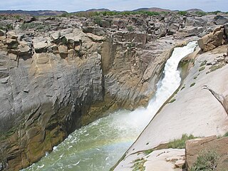
Augrabies Falls National Park is a national park located around the Augrabies Falls, about 120 km west of Upington in the Northern Cape Province, South Africa.

Hogsback is a village in the Amathole Mountains in the Eastern Cape Province, South Africa.

The Tsitsikamma National Park is a protected area on the Garden Route, Western Cape and Eastern Cape, South Africa. It is a coastal reserve well known for its indigenous forests, dramatic coastline, and the Otter Trail. On 6 March 2009 it was amalgamated with the Wilderness National Park and various other areas of land to form the Garden Route National Park.

Amatola, Amatole or Amathole are a range of densely forested mountains, situated in the Eastern Cape province of South Africa. The word Amathole means ‘calves’ in Xhosa, and Amathole District Municipality, which lies to the south, is named after these mountains.

Somerset East, officially renamed KwaNojoli in March 2023, is a town in the Blue Crane Route Local Municipality in the Eastern Cape, South Africa. It was founded by Lord Charles Somerset in 1825.

The Wild Coast is a section of the coast of the Eastern Cape, a province of South Africa. The region stretches from East London in the south to the border of KwaZulu-Natal in the north. It is the traditional home of the Mpondo people, and the birthplace of many prominent South Africans, including Nelson Mandela and Thabo Mbeki.

The Sehlabathebe National Park is located in the Maloti Mountains in Qacha's Nek District, Lesotho and is part of the Maloti-Drakensberg World Heritage Site. The park was first established on 8 May 1969 and since then, it is recognised important in terms of biological diversity and cultural heritage. The landscape is dominated by a grassland of various types. The larger ecosystem functions provide freshwater to Lesotho, South Africa, and Namibia.

The African Independent Congress (AIC) is a minor political party in South Africa.
Salmonsdam Nature Reserve is a nature reserve in the Overberg region of the Western Cape province of South Africa. It contains the mountain catchment area of the Paardensberg River in the Akkedisberg mountains. The reserve is administered by CapeNature and covers an area of 834 hectares.

Kogelberg Nature Reserve is a nature reserve of 3,000 ha comprising the Kogelberg Mountain Range, to the east of Cape Town, South Africa.

Cecilia is a section of the Table Mountain National Park on the lower eastern slopes of Table Mountain in Cape Town, located just to the south of Kirstenbosch National Botanical Garden. It was previously used for commercial logging and known as Cecilia Forest or Cecilia Plantation, but has now been given protected status and integrated into the National Park.

Lusikisiki is a town in the Ingquza Hill Local Municipality in the Eastern Cape Province, South Africa. The name is onomatopoeic, derived from the rustling sound of reeds in the wind, named by the local Xhosa people. Lusikisiki is 45 kilometres (28 mi) inland from and north of Port St Johns. The town is positioned along the R61 leading to Mthatha to the west and Port Shepstone to the north-east.
Breidbach is a neighborhood in King William's Town in South Africa, situated in the Border region of the Eastern Cape province.

Bluff Commando was a light infantry regiment of the South African Army. It formed part of the South African Army Infantry Formation as well as the South African Territorial Reserve.
The marine protected areas of South Africa are in an area of coastline or ocean within the exclusive economic zone (EEZ) of the Republic of South Africa that is protected in terms of specific legislation for the benefit of the environment and the people who live in and use it. An MPA is a place where marine life can thrive under less pressure than unprotected areas. They are like underwater parks, and this healthy environment can benefit neighbouring areas.
The following index is provided as an overview of and topical guide to the protected areas of South Africa:
