For many years before the Waterfront Development Corporation's founding in 1986 political leaders in Louisville had hoped to do something about what was perceived by much of the community as unattractive industrial areas and brownfields along the Ohio River in the downtown area. Due to the pressure of politics and the ever-changing makeup of the political leadership ideas and/or plans for the area's revitalization would often change. Community leaders sought to create an entity that would be insulated from electoral politics and therefore free to enact a long-term community vision for the revitalization Louisville Riverfront. An agreement to provide equal funding between the governments of Louisville, Jefferson County, and the Commonwealth of Kentucky led to the creation of the Waterfront Development Corporation.
Waterfront Development Corporation manages the downtown riverfront revitalization efforts, the centerpiece of which is Louisville Waterfront Park on the banks of the Ohio River. From the inception of the Articles of Incorporation WDC has been governed by a fifteen-member board of directors. Initially the board of directors was appointed equally between the three governments; this structure changed with the merger of Louisville, Jefferson County government. The post-merger structure has nine appointments from the city government and six from the state government.
After determining that a Downtown park was the public's favored redevelopment option the Board of Directors requested qualifications for creation of a Master Plan. After a lengthy review process of dozens of submissions the Board of Directors selected the Hargreaves Associates to create the Waterfront Park Master Plan. The Hargreaves plan was chosen as the submission that best connected the city back to its roots along the Ohio River, an example of this is the Great Lawn which actually connects the city grid to the river. The Great Lawn breaks the barrier of I-64 creating an open space between the river and Witherspoon Street.
The corporation's three-part mission includes oversight of the design and construction of Waterfront Park, operation of the park/ event coordination, and park maintenance. WDC also administers design review for properties within the Waterfront District (the Waterfront Review Overlay or WRO District).
Phase I of Waterfront Park, approximately 55 acres (220,000m2), was dedicated on July 4, 1999. The park hosted hundreds of events in its first full season of use, with an estimated total attendance of more than a million people. The park is heavily used on a daily basis, and averages more than 1.5 million visitors per year. Children and families enjoy the Children's Play Area and the new Adventure Playground, while walkers, joggers, picnickers, school groups, and others take advantage of its location along the river.
Phase II
Phase II of the park opened on June 10, 2004. Phase II l adds approximately 17 acres (69,000m2), including the Adventure Playground, which opened in July 2003; an esplanade along the river's edge; a cafe plaza where Tumbleweed will open in Spring 2005; the Brown-Forman amphitheater; docks for transient boaters; and an area for a new rowing facility for the University of Louisville Women's Rowing Team, school, and community rowing groups.
Adventure Playground
The Adventure Playground is double the size of the Children's Playground (Phase I). The playground includes a large jungle gym play structure and a water play area, complete with water cannons, fish sculptures that shoot water and geysers.
Phase III
Construction on Phase III began in September 2005, and fund raising is underway. Phase III covers 13 acres (53,000m2) that will include a pedestrian walkway across the river and more lawn areas, tree groves, walking paths, and picnic areas.
Riverview Park
Early in 2006 Metro MayorJerry Abramson asked The Waterfront Development Corporation to lead the proposed redevelopment of the Riverview Park (known to locals as "The Greenwood Boat Ramp") in southwest Jefferson County. The Waterfront Development Corporation Board agreed and initial design work has begun. The lead design staff on the project has held public meetings as the Master Plan is developed. No date has been set for completion.
Louisville is the most populous city in the Commonwealth of Kentucky, sixth-most populous city in the Southeast, and the 27th-most-populous city in the United States. Louisville is the historical seat and, since 2003, the nominal seat of Jefferson County, on the Indiana border.
George Hargreaves is a landscape architect. Under his design direction, the work of his firm has received numerous national awards and has been published and exhibited nationally and internationally. He was an artist in residence at the American Academy of Rome in 2009. Hargreaves and his firm designed numerous sites including the master plan for the Sydney 2000 Olympics, The Brightwater Waste Water Treatment Facility in Seattle, Washington, and University of Cincinnati Master Plan.
The Toronto waterfront is the lakeshore of Lake Ontario in the city of Toronto, Ontario, Canada. It spans 46 kilometres between the mouth of Etobicoke Creek in the west and the Rouge River in the east.
Governor Tom McCall Waterfront Park is a 36.59-acre (148,100 m2) park located in downtown Portland, Oregon, along the Willamette River. After the 1974 removal of Harbor Drive, a major milestone in the freeway removal movement, the park was opened to the public in 1978. The park covers 13 tax lots and is owned by the City of Portland. The park was renamed in 1984 to honor Tom McCall, the Oregon governor who pledged his support for the beautification of the west bank of the Willamette River—harkening back to the City Beautiful plans at the turn of the century which envisioned parks and greenways along the river. The park is bordered by RiverPlace to the south, the Steel Bridge to the north, Naito Parkway to the west, and Willamette River to the east. In October 2012, Waterfront Park was voted one of America's ten greatest public spaces by the American Planning Association.
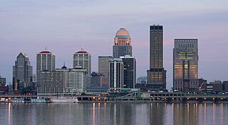
Downtown Louisville is the largest central business district in the Commonwealth of Kentucky and the urban hub of the Louisville, Kentucky Metropolitan Area. Its boundaries are the Ohio River to the north, Hancock Street to the east, York and Jacob Streets to the south, and 9th Street to the west. As of 2015, the population of Downtown Louisville was 4,700, although this does not include directly surrounding areas such as Old Louisville, Butchertown, NuLu, and Phoenix Hill.
Belle of Louisville is a steamboat owned and operated by the city of Louisville, Kentucky, and moored at its downtown wharf next to the Riverfront Plaza/Belvedere during its annual operational period. The steamboat claims itself the "most widely traveled river steamboat in American history." Belle of Louisville's offices are aboard Mayor Andrew Broaddus, and also appears on the list of National Historic Landmarks.
Louisville Waterfront Park is both a non-profit organization and an 85-acre (340,000 m2) public park adjacent to the downtown area of Louisville, Kentucky and the Ohio River. Specifically, it is adjacent to Louisville's wharf and Riverfront Plaza/Belvedere, which are situated to the west of the park. Once a wasteland of scrap yards and abandoned industrial buildings, Waterfront Park is now a vibrant green space that welcomes over 2.2 million visitors each year. Located in the park is the Big Four Bridge which connects the city of Louisville with the City of Jeffersonville, Indiana. Waterfront Park is home to some of Louisville's most exciting celebrations, such as the Fourth of July at Waterfront Park, Forecastle Festival, WFPK Waterfront Wednesdays and Thunder Over Louisville. In 2013 the park won the Rudy Bruner Award for Urban Excellence a national design award that seeks to identify and honor places that address economic and social concerns in urban design.
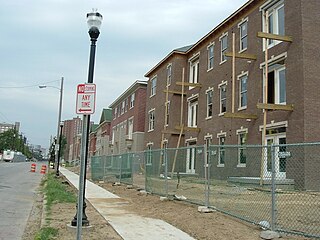
Phoenix Hill is a neighborhood of Louisville, Kentucky just east of Downtown. Its boundaries are Market Street to the North, Preston Street to the West, Broadway to the South, and Baxter Avenue to the East. The Phoenix Hill neighborhood, settled before 1850 by German immigrants, is now a rich tapestry of people and a diverse mix of business, industry and residences.
City of Parks is a municipal project to create a continuous paved pedestrian and biking trail around the city of Louisville, Kentucky while also adding a large amount of park land. The project was announced on February 22, 2005. Current plans call for making approximately 4,000 acres (1,600 ha) of the Floyds Fork floodplain in eastern Jefferson County into park space, expanding area in the Jefferson Memorial Forest, and adding riverfront land and wharfs along the Riverwalk Trail and Levee Trail. There are also plans to connect the 100-mile (160 km) Louisville trail to a planned seven mile (11 km) trail connecting the Southern Indiana cities of New Albany, Clarksville and Jeffersonville.
The Point was a thriving 19th century neighborhood in Louisville, Kentucky, east of Downtown Louisville and opposite Towhead Island along the Ohio River. It was also located north of the present day Butchertown area.
The government of Louisville, Kentucky, headquartered at Louisville City Hall in Downtown Louisville, is organized under Chapter 67C of the Kentucky Revised Statutes as a First-Class city in the state of Kentucky. Created after the merger of the governments of Louisville, Kentucky and Jefferson County, Kentucky, the city/county government is organized under a mayor-council system. The Mayor is elected to four-year terms and is responsible for the administration of city government. The Louisville Metro Council is a unicameral body consisting of 26 members, each elected from a geographic district, normally for four-year terms. The Mayor is limited to a two consecutive term limit, while members of the Louisville Metro Council are not term limited.
8664 was a grassroots campaign based in Louisville, Kentucky, that aimed "to advocate for the revitalization of Louisville through the removal of Interstate 64 (I-64) along the riverfront and the adoption of a transportation plan that will provide long-term benefits to the region's citizens, neighborhoods, environment and economy".
The Banks is a mixed-use development and neighborhood along the Ohio River in Cincinnati, Ohio, on the land between Paycor Stadium and Great American Ball Park.
Waterfront Toronto is an organization that oversees revitalization projects along the Toronto waterfront. Established in 2001 as a public–public partnership between the City of Toronto, Province of Ontario and Government of Canada, the organization is administering several blocks of land redevelopment projects surrounding Toronto Harbour and various other initiatives to promote the revitalization of the area, including public transit, housing developments, brownfield rehabilitation, possible removal of the Gardiner Expressway in the area, the Martin Goodman Trail and lakeshore improvements, and naturalization of the Don River. Actual development of the projects is done by other entities, primarily private corporations. The projects include a series of wavedeck walkways and gathering places designed by West 8 and DTAH.
Louisville, Kentucky is home to numerous structures that are noteworthy due to their architectural characteristics or historic associations, the most noteworthy being the Old Louisville neighborhood, the third largest historic preservation district in the United States. The city also boasts the postmodern Humana Building and an expanding Waterfront Park which has served to remove the former industrial appearance of the riverfront.
Interstate 64 (I-64) in the US state of Kentucky travels for 191 miles (307 km), passing by the major towns and cities of Louisville, Frankfort, Lexington, and Ashland. It has several major junctions with other Interstates, including I-65, I-71, I-264, and I-265 in Louisville and I-75 in Lexington.
Metropolitan Park is a 32-acre (130,000 m2) urban waterfront park and concert venue located on the north bank of the St. Johns River in Downtown Jacksonville, Florida. It is projected to be the eastern terminus of the northbank Jacksonville Riverwalk.
Newark Riverfront Park is a park and promenade being developed in phases along the Passaic River in Newark, New Jersey, United States. The park, expected to be 3 miles (4.8 km) long and encompass 30.5 acres (12.3 ha), is being created from brownfield and greyfield sites along the river, which itself is a Superfund site due to decades of pollution. It will follow the river between the Ironbound section along Raymond Boulevard and Downtown Newark along McCarter Highway. Announced in 1999, a groundbreaking took place in 2008, and the first phase of the park opened in 2012. It was the first time residents of the largest city in New Jersey have ever had public access to the river. Other segments of the park have subsequently opened, while others are being developed. The East Coast Greenway uses paths and roads along the park.
This page is based on this Wikipedia article Text is available under the CC BY-SA 4.0 license; additional terms may apply. Images, videos and audio are available under their respective licenses.