Waties Island, South Carolina

Last updated

Waties Island is an undeveloped barrier island in the eastern coast of South Carolina. It is under the jurisdiction of Coastal Carolina University and is used primarily as an educational research facility.

South Carolina State of the United States of America

South Carolina is a state in the Southeastern United States and the easternmost of the Deep South. It is bordered to the north by North Carolina, to the southeast by the Atlantic Ocean, and to the southwest by Georgia across the Savannah River.

Coastal Carolina University public, state-supported, liberal arts university in Conway, South Carolina, United States

Coastal Carolina University, commonly referred to as CCU or Coastal, is a public liberal arts university in Conway, South Carolina, which is located in the Myrtle Beach metropolitan area. Founded in 1954, Coastal became an independent university in 1993.

Contents

Maritime forest on Waties Island Maritime forest waties island.JPG
Maritime forest on Waties Island

History

Waties Island is named for either William Waties Jr. or Sr., who searched out and claimed large tracts of land in the Waccamaw, Pee Dee, and Horry/Georgetown areas.

Horry County, South Carolina County in the United States

Horry County is a county in the U.S. state of South Carolina. As of the 2010 census, its population was 289,650, making it the fifth-most populous county in South Carolina. The county seat is Conway.

Georgetown County, South Carolina County in the United States

Georgetown County is a county located in the U.S. state of South Carolina. As of the 2010 census, the population was 60,158. Its county seat is Georgetown. The county was founded in 1769. It is named for George III of the United Kingdom.

The island was inhabited by the Waccamaw Indians prior to the arrival of Europeans. The area was originally given to James Minor via a land grant, eventually coming into possession by Waties' family. For a short period, the island was known as Waiters Island on maps, due to a typographical error. The land was purchased in the 1920s by Horace Tilghman and given to Coastal Carolina University as a grant by his daughter, Anne.

The Waccamaw people are an indigenous people of the Southeastern Woodlands, who lived in villages along the Waccamaw River and Pee Dee River in North and South Carolina in the 18th century.

Significance

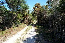
Waties Island is, for the most part, land untouched by human development. This is the result of the entire mass tending to fall under the jurisdiction of a single family or facility who choose not to develop it or have a distinct purpose in keeping the island undeveloped. This underdevelopment of the island contrasts sharply with the surrounding Grand Strand area, a beach region that is mostly developed. In addition, Waties Island is a barrier island with a significantly varying climate and ecology compared to the surrounding city land. It is one of the last remaining undeveloped barrier islands on the South Carolina coast. These factors have contributed to its use as a research area by students and faculty of Coastal Carolina University. The island has a conservation easement with The Nature Conservancy placed on it.

Grand Strand

The Grand Strand is a large stretch of beaches on the East Coast of the United States extending from Little River to Georgetown in the U.S. State of South Carolina. It consists of more than 60 miles (97 km) along an essentially uninterrupted arc of beach land, beginning around the Little River and terminating at Winyah Bay. The population of the Grand Strand was 329,449 at the 2010 United States Census.

Apart from its significance as an ecological research facility, it also has a rich anthropological history. The island is home to many American Indian artifacts, including burial mounds and ceramics.

Salt marsh at Waties Island Salt marsh at Waties Island.jpg
Salt marsh at Waties Island

Sources

Coordinates: 33°50′56″N78°34′29″W / 33.84889°N 78.57472°W / 33.84889; -78.57472


Related Research Articles

Sunset Beach, North Carolina Seaside town in North Carolina, United States

Sunset Beach is a seaside town in Brunswick County, North Carolina, United States. The population was 3,572 at the 2010 census, up from 1,824 at the 2000 census. It is part of the Myrtle Beach metropolitan area.

Pawleys Island, South Carolina Town in South Carolina, United States

Pawleys Island is a town in Georgetown County, South Carolina, United States, and the Atlantic coast barrier island on which the town is located.

Conway, South Carolina City in South Carolina, United States

Conway is a city in Horry County, South Carolina, United States. The population was 17,103 at the 2010 census, and had an estimated population in 2016 of 22,761. It is the county seat of Horry County and is part of the Myrtle Beach metropolitan area. It is the home of Coastal Carolina University.

Myrtle Beach, South Carolina City in South Carolina, United States

Myrtle Beach is a coastal city on the East Coast of the United States in Horry County, South Carolina. It is in the center of a large and continuous 60-mile (97 km) stretch of beach known as "The Grand Strand" in northeastern South Carolina.

Coastal Zone Management Act

The Coastal Zone Management Act of 1972 is an Act of Congress passed in 1972 to encourage coastal states to develop and implement coastal zone management plans (CZMPs). This act was established as a United States National policy to preserve, protect, develop, and where possible, restore or enhance, the resources of the Nation's coastal zone for this and succeeding generations.

Jones Lake State Park

Jones Lake State Park is a North Carolina state park in Bladen County, North Carolina in the United States near Elizabethtown. It covers 2,208-acre (8.94 km2), including the Carolina bay lakes of Jones Lake and Salters Lake. Jones Lake State Park is north of Elizabethtown on North Carolina Highway 242 in North Carolina's Coastal Plain region. The park offers year-round recreation, including fishing, swimming, boating, hiking, picnicking and environmental and historical education programs.

Waccamaw River river in the United States of America

The Waccamaw River is a river, approximately 140 miles (225 km) long, in southeastern North Carolina and eastern South Carolina in the United States. It drains an area of approximately 1110 square miles (2886 km²) in the coastal plain along the eastern border between the two states into the Atlantic Ocean. Along its upper course, it is a slow-moving, blackwater river surrounded by vast wetlands, passable only by shallow-draft watercraft such as canoe. Along its lower course, it is lined by sandy banks and old plantation houses, providing an important navigation channel with a unique geography, flowing roughly parallel to the coast.

Sea Islands chain of barrier islands in the United States

The Sea Islands are a chain of tidal and barrier islands on the Atlantic Ocean coast of the Southeastern United States. Numbering over 100, they are located between the mouths of the Santee and St. Johns Rivers along the coast of the US states of South Carolina, Georgia, and Florida.

Lake Waccamaw lake of the United States of America

Lake Waccamaw is a unique fresh water lake located in Columbus County in North Carolina. It is the largest of the natural Carolina Bay Lakes. The term "Bay" Lake stems from the abundance of bay trees growing in the numerous swampy oval depressions on the Carolina coastal plain. The lake is fed by four creeks: First, Second, Third, and Big Creeks. The outlet forms the Waccamaw River which flows southeasterly to empty into the Atlantic Ocean near Georgetown, South Carolina

The Waccamaw Neck is a long narrow peninsula between the Atlantic Ocean and the Waccamaw River in Georgetown County, South Carolina. The town of Pawleys Island is located on the Waccamaw Neck, as well as the unincorporated mainland area, which includes the areas of Litchfield Beach and North Litchfield Beach. The entire area shares Zip Code 29585. The Waccamaw Neck is located south of Myrtle Beach on the Grand Strand, and just north of the historic seaport of Georgetown.

Waccamaw Siouan Indians are one of eight state-recognized Native American tribal nations in North Carolina; they are also known as the "People of the Fallen Star". Historically Siouan-speaking, they are located predominantly in the southeastern North Carolina counties of Bladen and Columbus. They adopted this name in 1948, when their congressional representative introduced a bill for federal recognition.

The Coastal Barrier Resources Act of the United States was enacted October 18, 1982. The United States Congress passed this Act in order to address the many problems associated with coastal barrier development. CBRA designated various undeveloped coastal barriers, which were illustrated by a set of maps adopted by law, to be included in the John H. Chafee Coastal Barrier Resources System (CBRS). These designated areas were made ineligible for both direct and indirect federal expenditures and financial assistance, which are believed to encourage development of fragile, high-risk, and ecologically sensitive coastal barriers.

Bogue Banks

Bogue Banks form a 21-mile (34 km) barrier island off the mainland of North Carolina in Carteret County. The island, separated from the mainland by Bogue Sound, runs east to west, with the ocean beaches facing due south. Bogue Banks is the only island on the Carteret County shore that has been developed with housing: numerous communities are located on the island and can be accessed by one of two bridges across Bogue Sound, either from Morehead City to Atlantic Beach, which is the more heavily traveled bridge, or from Cape Carteret to Emerald Isle. The communities of Bogue Banks are the most prominent of the Crystal Coast. NC 58 traverses a majority of the island's length. There are several hotels that dot the island, but most of the land contains private houses, which are rented out during the summer, or maritime forest. Stores and other commercial properties are limited to the five main communities.


Bird Island is approximately 1,300 acres (5.3 km2) adjacent to the coastal resort town of Sunset Beach, North Carolina, USA. Sunset Beach is on a barrier island and is the southernmost town in North Carolina. Bird Island can be reached by walking along the seashore toward the South Carolina border. Due to the contour of the Atlantic Coast at this point, the direction of travel to Bird Island is approximately West-Southwest. Previously, Bird Island was separated from Sunset Beach by a tidal creek that could be easily crossed only at low tide. Accretion of ocean sand has gradually filled in the tidal creek so that two separate islands became one.

Kimbel Library is located in Conway, South Carolina, and is the academic library at Coastal Carolina University. It is named after William and Maud Kimbel, benefactors of the University.

Cape Grenville point in Australia

Cape Grenville, is a small, east-facing promontory along the Queensland, Australia coast of Cape York Peninsula. It lies between Shelburne Bay to the north and Temple Bay to the south. The nearest significant settlement is Weipa, along the western coast of Cape York.

Bramble Cay island

Bramble Cay, also called Maizab Kaur, Massaramcoer or Baramaki, and located at the northeastern edge of the Torres Strait Islands of Queensland and at the northern end of the Great Barrier Reef, is the northernmost point of land of Australia. It is 55 kilometres (34 mi) southeast of the mouth of the Fly River of Papua New Guinea.