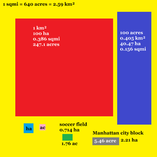
Square kilometre or square kilometer, symbol km2, is a multiple of the square metre, the SI unit of area or surface area.

Owings Mills is an unincorporated community and census-designated place in Baltimore County, Maryland, United States. It is a suburb of Baltimore. Per the 2020 census, the population was 35,674. Owings Mills is home to the northern terminus of the Baltimore Metro Subway, and housed the Owings Mills Mall until its closure in 2015. It is also home to the Baltimore Ravens' headquarters facility, and the studios for Maryland Public Television. In 2008, CNNMoney.com named Owings Mills number 49 of the "100 Best Places to Live and Launch".

Thurmont is a town in Frederick County, Maryland, United States. The population was 6,935 at the 2020 census. The town is located in the northern part of Frederick County, approximately ten miles from the Pennsylvania border, along U.S. Highway 15. It is very close to Cunningham Falls State Park and Catoctin Mountain Park, the latter of which contains the presidential retreat of Camp David. Thurmont is also home to Catoctin Colorfest, an arts and crafts festival that draws in about 125,000 people each autumn.

Kemp Mill is a census-designated place and an unincorporated census area in Montgomery County, Maryland, United States. The population was 13,378 at the 2020 census.

Montgomery Village is a census-designated place (CDP) in Montgomery County, Maryland, United States, and a northern suburb of Washington, D.C. It is a large, planned suburban community, developed in the late 1960s and 1970s just outside Gaithersburg's city limits. Montgomery Village's population was 34,893 at the time of the 2020 U.S. Census, and it is a part of the Washington metropolitan area.

Cambridge is a city in Isanti County, Minnesota, United States, located at the junction of Minnesota State Highways 65 and 95. The population was 9,611 at the 2020 census. It is the county seat of Isanti County. It is located along the Rum River and BNSF's Hinckley Subdivision. Cambridge is notable for having the highest percentage of Swedish Americans of any city in the United States with a population of over 5,000 people.

Roanoke Rapids is a city in Halifax County, North Carolina, United States. The population was 15,754 at the 2010 census. It is the principal city of the Roanoke Rapids Micropolitan Statistical Area, and is also an anchor city of the Rocky Mount-Wilson-Roanoke Rapids CSA, with a total population of 297,726 as of 2018.

Independence is a town in Southwestern Virginia's Grayson County, with a population of 1,001 as of the 2020 census. As the Grayson County Seat, it is located 71 miles from Winston-Salem, North Carolina, the closest city with a population over 50,000, and is situated on Virginia's Crooked Road, a heritage trail celebrating the musical heritage of Western and Southwest Virginia.

Hillsboro is a rural town in Loudoun County, Virginia, United States. The population was 80 at the 2010 census and an estimated 169 as of 2019.
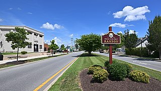
The City of Ranson is a city in Jefferson County, West Virginia, United States. The population was 5433 at the 2020 census. Although the Census Bureau listed it as a town in 2000, it is classified as a city by state law.
Jewell is a hamlet in Oneida County, New York, United States. It is a community in the Town of Vienna, on the northeastern corner of Oneida Lake, near the border of Oswego County. It lies on State Route 49, approximately 30 minutes from the City of Syracuse to its west and 30 minutes to the City of Utica on the east.

Rock Creek is an 18.9-mile-long (30.4 km) tributary of the Monocacy River in south-central Pennsylvania and serves as the border between Cumberland and Mount Joy townships. Rock Creek was used by the Underground Railroad and flows near several Gettysburg Battlefield sites, including Culp's Hill, the Benner Hill artillery location, and Barlow Knoll.
The Rural Municipality of Langford is a former rural municipality (RM) in the Canadian province of Manitoba. It was originally incorporated as a rural municipality on November 1, 1890. It ceased on January 1, 2015 as a result of its provincially mandated amalgamation with the RM of North Cypress to form the Municipality of North Cypress – Langford.

Saint-Hélène-de-Breakeyville is a district (secteur) within the Les Chutes-de-la-Chaudière-Est borough of the city of Lévis. It is located on the Chaudière River. Prior to 2002, it was an independent municipality.
Defina is a small town and commune in the Cercle of Bougouni in the Sikasso Region of southern Mali. In 1998 the commune had a population of 6,109.
Hicoria was a town in Highlands County, Florida. The town was situated 5 miles (8.0 km) south of Lake Placid and was established in the 1890s.
Moscow Mills is a former town in Morgan County, in the U.S. state of Ohio. The GNIS classifies it as a populated place.

A split intersection is a rarely built at-grade variant of the diamond interchange. Compared to a conventional four-leg intersection or road crossing, the arterial road is split into separate carriageways by 200 to 300 feet, allowing a queue of left turning vehicles behind a completed turn into the crossroad without any conflict to oncoming traffic. On the crossroad, the four leg intersection is being replaced by two intersections. The beginning one-way traffic at the fourth leg makes the intersections reduce the number of conflicts similar to a three leg T-intersection to improve traffic flow.