The Chesapeake Bay is the largest estuary in the United States. The Bay is located in the Mid-Atlantic region and is primarily separated from the Atlantic Ocean by the Delmarva Peninsula, including parts of the Eastern Shore of Maryland, the Eastern Shore of Virginia, and the state of Delaware. The mouth of the Bay at its southern point is located between Cape Henry and Cape Charles. With its northern portion in Maryland and the southern part in Virginia, the Chesapeake Bay is a very important feature for the ecology and economy of those two states, as well as others surrounding within its watershed. More than 150 major rivers and streams flow into the Bay's 64,299-square-mile (166,534 km2) drainage basin, which covers parts of six states and all of Washington, D.C.

Tangier is a town in Accomack County, Virginia, United States, on Tangier Island in the Chesapeake Bay. The population was 436 at the 2020 census. Since 1850, the island's landmass has been reduced by 67%. Under the mid-range sea level rise scenario, much of the remaining landmass is expected to be lost in the next 50 years and the town will likely need to be abandoned.

John Smith was an English soldier, explorer, colonial governor, admiral of New England, and author. He played an important role in the establishment of the colony at Jamestown, Virginia, the first permanent English settlement in North America, in the early 17th century. He was a leader of the Virginia Colony between September 1608 and August 1609, and he led an exploration along the rivers of Virginia and the Chesapeake Bay, during which he became the first English explorer to map the Chesapeake Bay area. Later, he explored and mapped the coast of New England. He was knighted for his services to Sigismund Báthory, Prince of Transylvania, and his friend Mózes Székely.

The Southern Colonies within British America consisted of the Province of Maryland, the Colony of Virginia, the Province of Carolina, and the Province of Georgia. In 1763, the newly created colonies of East Florida and West Florida would be added to the Southern Colonies by Great Britain until the Spanish Empire took back Florida. These colonies were the historical core of what would become the Southern United States, or "Dixie". They were located south of the Middle Colonies, albeit Virginia and Maryland were also called the Chesapeake Colonies.

The Province of Maryland was an English and later British colony in North America from 1634 until 1776, when the province was one of the Thirteen Colonies that joined in supporting the American Revolution against Great Britain. In 1781, Maryland was the 13th signatory to the Articles of Confederation. The province's first settlement and capital was in St. Mary's City, located at the southern end of St. Mary's County, a peninsula in the Chesapeake Bay bordered by four tidal rivers.

William Claiborne also, spelled Cleyburne was an English pioneer, surveyor, and an early settler in the colonies/provinces of Virginia and Maryland and around the Chesapeake Bay. Claiborne became a wealthy merchant and planter, as well as a major political figure in the mid-Atlantic colonies. He featured in disputes between the colonists of Virginia and the later settling of Maryland, partly because of his earlier trading post on Kent Island in the mid-way of the Chesapeake Bay, which provoked the first naval military battles in North American waters. Claiborne repeatedly attempted and failed to regain Kent Island from the Maryland Calverts, sometimes by force of arms, after its inclusion in the lands that were granted by a 1632 Royal Charter to the Calvert family. Kent Island had become Maryland territory after the surrounding lands were granted to Sir George Calvert, first Baron and Lord Baltimore (1579–1632) by the reigning King of England, Charles I.

The recorded history of Maryland dates back to the beginning of European exploration, starting with the Venetian John Cabot, who explored the coast of North America for the Kingdom of England in 1498. After European settlements had been made to the south and north, the colonial Province of Maryland was granted by King Charles I to Sir George Calvert (1579–1632), his former Secretary of State in 1632, for settlement beginning in March 1634. It was notable for having been established with religious freedom for Roman Catholics, since Calvert had publicly converted to that faith. Like other colonies and settlements of the Chesapeake Bay region, its economy was soon based on tobacco as a commodity crop, highly prized among the English, cultivated primarily by African slave labor, although many young people came from Britain sent as indentured servants or criminal prisoners in the early years.

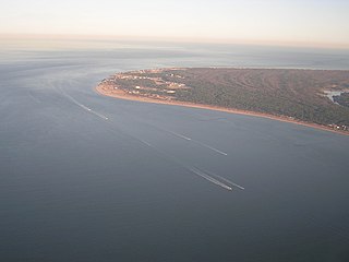
Cape Henry is a cape on the Atlantic shore of Virginia located in the northeast corner of Virginia Beach. It is the southern boundary of the entrance to the long estuary of the Chesapeake Bay.
The Battle of Caulk's Field was fought during the War of 1812 in Kent County, Maryland between a small British Army force commanded by Captain Sir Peter Parker and American militia forces commanded by Lieutenant Colonel Philip Reed. Parker, who was operating in the Chesapeake Bay region as part of the British campaign against Baltimore, Maryland, landed on the eastern shore of the Chesapeake Bay to move against Reed's militia encampment. The British attacking force encountered American skirmishers, who conducting a fighting retreat, drawing the British towards the main American line. Parker was mortally wounded during the fight, and the British force withdrew after Parker fell. Later British setbacks at the Battle of North Point and the Battle of Fort McHenry led the British to abandon their campaign against Baltimore. In 2012, the battlefield was the site of an archaeological survey.

The Watts Island Light was a historic lighthouse located near Watts Island in the Chesapeake Bay. It was the only lighthouse built by John Donahoo outside of Maryland.
The Virginia Cavaliers baseball team represents the University of Virginia in NCAA Division I college baseball. Established in 1889, the team participates in the Coastal division of the Atlantic Coast Conference and plays its home games at Davenport Field at Disharoon Park. The team's head coach is Brian O'Connor. The team has reached the College World Series seven times, most recently in 2024, and won the national championship in 2015.
Gilbert Clarence Klingel (1908–1983) was a naturalist, boatbuilder, adventurer, photographer, author, inventor, contributor to the Baltimore Sun, for a time affiliated with the American Museum of Natural History in New York and a member of the Maryland Academy of Sciences, and a curator and charter member of the Natural History Society of Maryland. He is best known for his book about the Chesapeake Bay, The Bay, which won the John Burroughs Medal in 1953.

Glenn Martin National Wildlife Refuge includes the northern half of Smith Island, which lies 11 miles (18 km) west of Crisfield, Maryland, and Watts Island, which is located between the eastern shore of Virginia and Tangier Island. Both islands are situated in the lower Chesapeake Bay.
Pocomoke Sound is a bay of the Chesapeake Bay that forms part of the boundary between the Eastern Shores of Maryland and Virginia. The Pocomoke River is the largest stream feeding into the Sound, which is bounded by Somerset County, Maryland on the north, Worcester County, Maryland, Accomack County, Virginia, and Beasley Bay on the east, the Chesapeake Bay on the south, and Tangier Sound on the west. Its southwesternmost point may be considered to be Watts Island, Virginia.

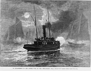
The Oyster Wars were a series of sometimes violent disputes between oyster pirates and authorities and legal watermen from Maryland and Virginia in the waters of the Chesapeake Bay and the Potomac River from 1865 until about 1959.

The English overseas possessions, also known as the English colonial empire, comprised a variety of overseas territories that were colonised, conquered, or otherwise acquired by the former Kingdom of England during the centuries before the Acts of Union of 1707 between the Kingdom of England and the Kingdom of Scotland created the Kingdom of Great Britain. The many English possessions then became the foundation of the British Empire and its fast-growing naval and mercantile power, which until then had yet to overtake those of the Dutch Republic, the Kingdom of Portugal, and the Crown of Castile.

The history of human activity in Chincoteague, on the Eastern Shore of Virginia, begins with the Native Americans. Until European explorers possessed the island in the late 17th century, the Chincoteague Indians used it as a place to gather shellfish, but are not known to have lived there; Chincoteague Island lacked suitable soil for their agriculture. The island's name derives from those early visitors: by one popular tale, chincoteague meant "Beautiful land across the water" in their language.
The history of Native Americans in Baltimore and what is now Baltimore dates back at least 12,000 years. As of 2014, Baltimore is home to a small Native American population, centered in East Baltimore. The majority of Native Americans now living in Baltimore belong to the Lumbee, Piscataway, and Cherokee peoples. The Piscataway people live in Southern Maryland and are recognized by the state of Maryland. The Lumbee and Cherokee are Indigenous to North Carolina and neighboring states of the Southeastern United States. Many of the Lumbee and Cherokee migrated to Baltimore during the mid-20th century along with other migrants from the Southern United States, such as African-Americans and white Appalachians. The Lumbee are state recognized in North Carolina as the Lumbee Tribe of North Carolina, but have no state recognition in Maryland. The Eastern Band of Cherokee Indians in North Carolina are a federally recognized tribe. There are three state recognized tribes in Maryland; the Piscataway-Conoy Tribe of Maryland, the Piscataway Indian Nation and Tayac Territory, and the Accohannock Indian Tribe. Maryland has no federally recognized tribes.
The Ozinie, also known as the Wicomiss, were a group of Native Americans living near modern-day Rock Hall, in Kent County, Maryland. They were hunter-gatherers and fished.

The Indigenous peoples of Maryland are the tribes who historically and currently live in the land that is now the State of Maryland in the United States of America. These tribes belong to the Northeastern Woodlands, a cultural region.


