Related Research Articles
In computing, the Open Geospatial Consortium Web Feature Service (WFS) Interface Standard provides an interface allowing requests for geographical features across the web using platform-independent calls. One can think of geographical features as the "source code" behind a map, whereas the WMS interface or online tiled mapping portals like Google Maps return only an image, which end-users cannot edit or spatially analyze. The XML-based GML furnishes the default payload-encoding for transporting geographic features, but other formats like shapefiles can also serve for transport. In early 2006 the OGC members approved the OpenGIS GML Simple Features Profile. This profile is designed both to increase interoperability between WFS servers and to improve the ease of implementation of the WFS standard.
A GIS file format is a standard for encoding geographical information into a computer file, as a specialized type of file format for use in geographic information systems (GIS) and other geospatial applications. Since the 1970s, dozens of formats have been created based on various data models for various purposes. They have been created by government mapping agencies, GIS software vendors, standards bodies such as the Open Geospatial Consortium, informal user communities, and even individual developers.
GeoTIFF is a public domain metadata standard which allows georeferencing information to be embedded within a TIFF file. The potential additional information includes map projection, coordinate systems, ellipsoids, datums, and everything else necessary to establish the exact spatial reference for the file. The GeoTIFF format is fully compliant with TIFF 6.0, so software incapable of reading and interpreting the specialized metadata will still be able to open a GeoTIFF format file.
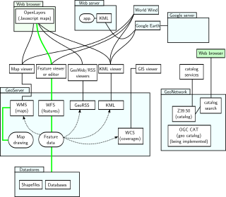
In computing, GeoServer is an open-source server written in Java that allows users to share, process and edit geospatial data. Designed for interoperability, it publishes data from any major spatial data source using open standards. GeoServer has evolved to become an easy method of connecting existing information to virtual globes such as Google Earth and NASA World Wind as well as to web-based maps such as OpenLayers, Leaflet, Google Maps and Bing Maps. GeoServer functions as the reference implementation of the Open Geospatial Consortium Web Feature Service standard, and also implements the Web Map Service, Web Coverage Service and Web Processing Service specifications.
A GIS software program is a computer program to support the use of a geographic information system, providing the ability to create, store, manage, query, analyze, and visualize geographic data, that is, data representing phenomena for which location is important. The GIS software industry encompasses a broad range of commercial and open-source products that provide some or all of these capabilities within various information technology architectures.
Keyhole Markup Language (KML) is an XML notation for expressing geographic annotation and visualization within two-dimensional maps and three-dimensional Earth browsers. KML was developed for use with Google Earth, which was originally named Keyhole Earth Viewer. It was created by Keyhole, Inc, which was acquired by Google in 2004. KML became an international standard of the Open Geospatial Consortium in 2008. Google Earth was the first program able to view and graphically edit KML files, but KML support is now available in many GIS software applications, such as Marble, QGIS, and ArcGIS.
A Web Map Service (WMS) is a standard protocol developed by the Open Geospatial Consortium in 1999 for serving georeferenced map images over the Internet. These images are typically produced by a map server from data provided by a GIS database.
Catalogue Service for the Web (CSW), sometimes seen as Catalogue Service - Web, is a standard for exposing a catalogue of geospatial records in XML on the Internet. The catalogue is made up of records that describe geospatial data, geospatial services, and related resources.
The Open Source Geospatial Foundation (OSGeo), is a non-profit non-governmental organization whose mission is to support and promote the collaborative development of open geospatial technologies and data. The foundation was formed in February 2006 to provide financial, organizational and legal support to the broader Libre/Free and open-source geospatial community. It also serves as an independent legal entity to which community members can contribute code, funding and other resources.
Mapbender is a graduated project of the Open Source Geospatial Foundation. It was awarded OGC web site of the month in 2008. It is used by PortalU and several federal states to implement the INSPIRE regulation. Many municipalities use Mapbender as City Map Services and it is used as the mapping framework for online cycle route planners.
In cartography, a Styled Layer Descriptor (SLD) is an XML schema specified by the Open Geospatial Consortium (OGC) for describing the appearance of map layers. It is capable of describing the rendering of vector and raster data. A typical use of SLDs is to instruct a Web Map Service (WMS) how to render a specific layer.
OpenLayers is a JavaScript library for displaying map data in web browsers as slippy maps. It provides an API for building rich web-based geographic applications similar to Google Maps and Bing Maps.
The OGC Web Processing Service (WPS) Interface Standard provides rules for standardizing inputs and outputs for invoking geospatial processing services, such as polygon overlay, as a web service. The WPS standard defines how a client can request the execution of a process, and how the output from the process is handled. It defines an interface that facilitates the publishing of geospatial processes and clients’ discovery of and binding to those processes. The data required by the WPS can be delivered across a network or they can be available at the server. WPS can describe any calculation including all of its inputs and outputs, and trigger its execution as a web service. WPS supports simultaneous exposure of processes via HTTP GET, HTTP POST, and SOAP, thus allowing the client to choose the most appropriate interface mechanism. The specific processes served up by a WPS implementation are defined by the owner of that implementation. Although WPS was designed to work with spatially referenced data, it can be used with any kind of data.
The Open Geospatial Consortium (OGC) Web Coverage Service (WCS) Interface Standard defines a web-based interface for the retrieval of coverages—that is, digital geospatial information representing space/time-varying phenomena. By providing direct access to underlying geospatial data rather than just static map images, WCS enables more advanced analysis, modeling, and processing of GIS data.
Tile Map Service or TMS, is a specification for tiled web maps, developed by the Open Source Geospatial Foundation. The definition generally requires a URI structure which attempts to fulfill REST principles. The TMS protocol fills a gap between the very simple standard used by OpenStreetMap and the complexity of the Web Map Service standard, providing simple urls to tiles while also supporting alternate spatial referencing system.
SpatiaLite is a spatial extension to SQLite, providing vector geodatabase functionality. It is similar to PostGIS, Oracle Spatial, and SQL Server with spatial extensions, although SQLite/SpatiaLite aren't based on client-server architecture: they adopt a simpler personal architecture. i.e. the whole SQL engine is directly embedded within the application itself: a complete database simply is an ordinary file which can be freely copied and transferred from one computer/OS to a different one without any special precaution.
The Open Geospatial Consortium (OGC) is an international voluntary consensus standards organization that develops and maintains international standards for geospatial content and location-based services, sensor web, Internet of Things, GIS data processing and data sharing. The OGC was incorporated as a not for profit in 1994. At that time, the official name was the OpenGIS Consortium. Currently, commercial, government, nonprofit, universities, and research organizations participate in a consensus process encouraging development, maintenance, and implementation of open standards.
The Web Coverage Processing Service (WCPS) defines a language for filtering and processing of multi-dimensional raster coverages, such as sensor, simulation, image, and statistics data. The Web Coverage Processing Service is maintained by the Open Geospatial Consortium (OGC). This raster query language allows clients to obtain original coverage data, or derived information, in a platform-neutral manner over the Web.

A tiled web map,slippy map or tile map is a map displayed in a web browser by seamlessly joining dozens of individually requested image or vector data files. It is the most popular way to display and navigate maps, replacing other methods such as Web Map Service (WMS) which typically display a single large image, with arrow buttons to navigate to nearby areas. Google Maps was one of the first major mapping sites to use this technique. The first tiled web maps used raster tiles, before the emergence of vector tiles.

Web GIS, or Web Geographic Information Systems, are GIS that employ the World Wide Web to facilitate the storage, visualization, analysis, and distribution of spatial information over the Internet. The World Wide Web, or the Web, is an information system that uses the internet to host, share, and distribute documents, images, and other data. Web GIS involves using the World Wide Web to facilitate GIS tasks traditionally done on a desktop computer, as well as enabling the sharing of maps and spatial data. While Web GIS and Internet GIS are sometimes used interchangeably, they are different concepts. Web GIS is a subset of Internet GIS, which is itself a subset of distributed GIS, which itself is a subset of broader Geographic information system. The most common application of Web GIS is Web mapping, so much so that the two terms are often used interchangeably in much the same way as Digital mapping and GIS. However, Web GIS and web mapping are distinct concepts, with web mapping not necessarily requiring a Web GIS.
References
- 1 2 "OpenGIS® Web Map Tile Service Implementation Standard" . Retrieved 5 April 2013.
- ↑ "OGC Document Notice" . Retrieved 2 February 2011.
- ↑ Doyle, Allan (1997). "WWW Mapping Framework" (Document). Open GIS Consortium.