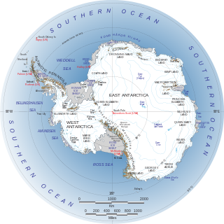
The Weddell Sea is part of the Southern Ocean and contains the Weddell Gyre. Its land boundaries are defined by the bay formed from the coasts of Coats Land and the Antarctic Peninsula. The easternmost point is Cape Norvegia at Princess Martha Coast, Queen Maud Land. To the east of Cape Norvegia is the King Haakon VII Sea. Much of the southern part of the sea is covered by a permanent, massive ice shelf field, the Filchner-Ronne Ice Shelf.

Sir Vivian Ernest Fuchs was an English scientist-explorer and expedition organizer. He led the Commonwealth Trans-Antarctic Expedition which reached the South Pole overland in 1958.

The Antarctic realm is one of eight terrestrial biogeographic realms. The ecosystem includes Antarctica and several island groups in the southern Atlantic and Indian oceans. The continent of Antarctica is so cold that it has supported only 2 vascular plants for millions of years, and its flora presently consists of around 250 lichens, 100 mosses, 25-30 liverworts, and around 700 terrestrial and aquatic algal species, which live on the areas of exposed rock and soil around the shore of the continent. Antarctica's two flowering plant species, the Antarctic hair grass and Antarctic pearlwort, are found on the northern and western parts of the Antarctic Peninsula. Antarctica is also home to a diversity of animal life, including penguins, seals, and whales.

Finn Ronne was a Norwegian-born U.S. citizen and Antarctic explorer.

The Recovery Glacier is a glacier flowing west along the southern side of the Shackleton Range in Antarctica. First seen from the air and examined from the ground by the Commonwealth Trans-Antarctic Expedition in 1957, it was so named because of the recovery of the expedition's vehicles which repeatedly broke into bridged crevasses on this glacier during the early stages of the crossing of Antarctica. It is at least 100 km (60 mi) long and 64 km (40 mi) wide at its mouth.

The Weddell seal is a relatively large and abundant true seal with a circumpolar distribution surrounding Antarctica. The Weddell seal was discovered and named in the 1820s during expeditions led by British sealing captain James Weddell to the area of the Southern Ocean now known as the Weddell Sea. The life history of this species is well documented since it occupies fast ice environments close to the Antarctic continent and often adjacent to Antarctic bases. It is the only species in the genus Leptonychotes.

West Antarctica, or Lesser Antarctica, one of the two major regions of Antarctica, is the part of that continent that lies within the Western Hemisphere, and includes the Antarctic Peninsula. It is separated from East Antarctica by the Transantarctic Mountains and is covered by the West Antarctic Ice Sheet. It lies between the Ross Sea, and the Weddell Sea. It may be considered a giant peninsula, stretching from the South Pole towards the tip of South America.

East Antarctica, also called Greater Antarctica, constitutes the majority (two-thirds) of the Antarctic continent, lying on the Indian Ocean side of the continent, separated from West Antarctica by the Transantarctic Mountains. It lies almost entirely within the Eastern Hemisphere and its name has been accepted for more than a century. It is generally higher than West Antarctica and includes the Gamburtsev Mountain Range in the center. The geographic South Pole is located within East Antarctica.
The Ronne Antarctic Research Expedition (RARE) was an expedition from 1947–1948 which researched the area surrounding the head of the Weddell Sea in Antarctica.
The Soviet Antarctic Expedition was part of the Arctic and Antarctic Research Institute of the Soviet Committee on Antarctic Research of the Academy of Sciences of the USSR.

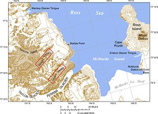
The Erebus Ice Tongue is a mountain outlet glacier and the seaward extension of Erebus Glacier from Ross Island. It projects 11 kilometres (6.8 mi) into McMurdo Sound from the Ross Island coastline near Cape Evans, Antarctica. The glacier tongue varies in thickness from 50 metres (160 ft) at the snout to 300 metres (980 ft) at the point where it is grounded on the shoreline. Explorers from Robert F. Scott's Discovery Expedition (1901–1904) named and charted the ice tongue.

The Horse Block is a sea stack of the Falkland Islands. It is situated off the southwest coast of Weddell Island, 1.8 km southwest of Pillar Bluff.
The Weddell Islands are a group of small islands and rocks lying 1.9 km (1.2 mi) south of Saddle Island and 9 km (5.6 mi) lying north of the western end of Laurie Island, in the South Orkney Islands of Antarctica. They were probably first seen during a joint cruise by Captains Nathaniel B. Palmer and George Powell in December 1821. The name first appears on James Weddell's chart resulting from his exploration of the South Orkney Islands in 1823.

The Dawson-Lambton Glacier is a heavily crevassed glacier entering the south-eastern Weddell Sea immediately west of the Brunt Ice Shelf. It was discovered in January 1915 by a British expedition led by Ernest Shackleton. He named it for Elizabeth Dawson-Lambton, a benefactress of the Shackleton expeditions.

Swan Point is the point on the southwest side of the entrance to Queen Charlotte Bay, forming the northeast extremity of Weddell Island in the Falkland Islands.
Mount Weddell is the summit of Weddell Island in the Falkland Islands. The mountain rises to 383 metres (1,257 ft) and is situated 8 km northeast of Race Point, 9.8 km east of Pillar Bluff, 4.35 km southwest of Weddell Settlement and 4.6 km west-northwest of Circum Point.

Pillar Bluff is a headland projecting 1.1 km from the southwest coast of Weddell Island in the Falkland Islands and forming the west side of the entrance to Pillar Cove. It is located at 51°55′47″S61°05′44″W, which is 9.3 km northwest of Race Point, 1.8 km northeast of Horse Block, 4 km southeast of Weddell Point and 9.8 km west of Mount Weddell.

French Harbour is the 500 m wide bay indenting for 3.1 km the west coast of Weddell Island in the Falkland Islands. It is entered 5.5 km north of Weddell Point, and centred at 51°51′03″S61°06′50″W.

Quaker Harbour is the irregularly shaped bay indenting for 3.7 km the north coast of Weddell Island in the Falkland Islands. It is centred at 51°49′00″S61°04′35″W, and has its head fed by Pitt Creek. The bay takes its name from nearby Quaker Island.
Circum Peak is a mountain rising to 198 m (650 ft) in the southeast part of Weddell Island in the Falkland Islands. It is located at, which is 2.12 km (1.32 mi) southeast of Mount Weddell, and surmounts New Year Cove to the southeast and Gull Harbour to the northeast.


