
U.S. Route 66 or U.S. Highway 66 was one of the original highways in the United States Numbered Highway System. It was established on November 11, 1926, with road signs erected the following year. The highway, which became one of the most famous roads in the United States, originally ran from Chicago, Illinois, through Missouri, Kansas, Oklahoma, Texas, New Mexico, and Arizona before terminating in Santa Monica in Los Angeles County, California, covering a total of 2,448 miles (3,940 km).

Interstate 55 (I-55) is a major Interstate Highway in the central United States. As with most primary Interstates that end in a five, it is a major cross-country, north–south route, connecting the Gulf of Mexico to the Great Lakes. The highway travels from LaPlace, Louisiana, at I-10 to Chicago, Illinois, at U.S. Route 41, at McCormick Place. The major cities that I-55 connects to are New Orleans, Louisiana; Jackson, Mississippi; Memphis, Tennessee; St. Louis, Missouri; and Chicago, Illinois.
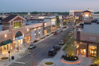
Bolingbrook is a village in Will and DuPage counties in the U.S. state of Illinois. It is a southwest suburb of Chicago on I-55 and Historic Route 66. The village was a new town built on the Gateway Wetlands west of the Des Plaines River in the 1960s. Bolingbrook experienced rapid growth in the 1980s and 1990s, and eventually became the second largest town in the county after Joliet. Per the 2020 census, the population was 73,922. As of 2010, it is the 17th largest incorporated place in Illinois and the state's 2nd largest village.

Joliet is a city in Will and Kendall counties in the U.S. state of Illinois, 35 miles (56 km) southwest of Chicago. It is the county seat of Will County. At the 2020 census, the city was the third-largest in Illinois, with a population of 150,362.

Plainfield is a village in Will and Kendall counties, Illinois, United States. The population was 44,762 at the 2020 census.

Wilmington is a city in Will County, Illinois, United States. Located on IL-53 along the east bank of the Kankakee River, it is approximately 60 miles south-west from downtown Chicago. The population was 5,724 at the 2010 census.
A rest area is a public facility located next to a large thoroughfare such as a motorway, expressway, or highway, at which drivers and passengers can rest, eat, or refuel without exiting onto secondary roads. Other names include motorway service area (UK), services (UK), travel plaza, rest stop, oasis (US), service area, rest and service area (RSA), resto, service plaza, lay-by, and service centre (Canada). Facilities may include park-like areas, fuel stations, public toilets, water fountains, restaurants, and dump and fill stations for caravans / motorhomes.

Illinois Route 53 (IL 53) is an arterial north–south state highway in northeast Illinois. IL 53 runs from Main Street west of historic U.S. Route 66 (US 66) in Gardner to IL 83 in Long Grove, a distance of 82.02 miles (132.00 km). It mainly cuts through the western suburbs of Chicago, passes through Bolingbrook, Romeoville, Crest Hill and Joliet, merging into I-55 at Gardner.

Illinois Route 59 is a north–south state highway in northeastern Illinois. It runs south from Illinois Route 173 in Antioch to I-55 in Shorewood, spanning the north–south width of Chicago's western suburbs. This is a distance of 71.13 miles (114.47 km).

Illinois Route 4 is a major north–south highway that runs south from the Interstate 55 business loop around the state capital of Springfield, south to Illinois Route 13 just north of Murphysboro. This is a distance of 170.44 miles (274.30 km).
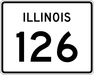
Illinois Route 126 (IL 126) is a 17.25-mile-long (27.76 km) east–west state highway in the northern part of the U.S. state of Illinois. It travels from IL 47 in Yorkville to Interstate 55 (I-55) between Plainfield and Bolingbrook.
U.S. Route 66 was a United States Numbered Highway in Illinois that connected St. Louis, Missouri, and Chicago, Illinois. The historic Route 66, the Mother Road or Main Street of America, took long distance automobile travelers from Chicago to Southern California. The highway had previously been Illinois Route 4 and the road has now been largely replaced with Interstate 55 (I-55). Parts of the road still carry traffic and six separate portions of the roadbed have been listed on the National Register of Historic Places.

Joliet Union Station was a train station in Joliet, Illinois that served Amtrak long-distance and Metra commuter trains. It was replaced by the new Joliet Transportation Center in 2018, a train station that was constructed adjacent to the Union Station's location. Train service to Joliet Union Station permanently ceased in September 2014. The station is 37.0 miles (59.5 km) from Chicago Union Station on the Heritage Corridor, and 40.1 miles (64.5 km) from Chicago LaSalle St. Station on the Rock Island District.

Ron George Round Barn is a round barn northeast of the U.S. village of Romeoville, Illinois. It was originally constructed for Frank Eaton c. 1912–13 in Bolingbrook, Illinois.
Interstate 55 (I-55) is a major north–south Interstate Highway in the US state of Illinois that connects St. Louis, Missouri, to the Chicago metropolitan area. It enters the state from Missouri near East St. Louis, Illinois, and runs to U.S. Route 41 near Downtown Chicago, where the highway ends, a distance of 294.38 miles (473.76 km). The road also runs through the Illinois cities of Springfield, Bloomington, and Joliet. The section in Cook County is officially named the Stevenson Expressway, and in DuPage County its officially named the Joliet Freeway or the Will Rogers Freeway. The section from the south suburbs of Chicago to the area near Pontiac is officially named the Barack Obama Presidential Expressway after the 44th President, Barack Obama, who launched his political career from Illinois.

Dell Rhea's Chicken Basket is a restaurant in Willowbrook, DuPage County, Illinois. It is located along historical U.S. Route 66, near present-day Interstate 55.

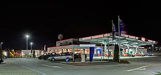
The Dixie Travel Plaza, previously known as the Dixie Truck Stop and Dixie Trucker's Home, is a large trucker and travel plaza located in McLean, Illinois, on Interstate 55. It was established by J.P. Walters and John Geske in 1928 on old US Route 66 as a small sandwich stand in a truck mechanic's garage. By 1930, quickly growing demand had necessitated expansion into a full-size restaurant. The restaurant was expanded several times afterwards, and rebuilt once after a fire in 1965. Walters, Geske and the Dixie Trucker's Home have been recognized by the Route 66 Association of Illinois for their contributions—from 1926 to 1977—to the character of Route 66. They were inducted into the association's hall of fame on June 9, 1990. Dixie was previously home to the Route 66 Hall of Fame when it opened in 1990. In 2003, after Dixie changed ownership, the museum was moved to a new, larger location in Pontiac, Illinois.
The Berwyn Route 66 Museum was a small not-for-profit facility, located in Berwyn, Illinois, that documented the history of the former U.S. Route 66. It has been closed now.
The Joliet Area Historical Museum is a historical museum located in Joliet, Illinois. The museum documents the history of Joliet and surrounding Will County.

Peoria Charter Coach Company is a family-owned bus company based in Peoria, Illinois, which provides charter bus services, custom group tours, and transportation from several universities in Illinois to Chicago suburbs and airports. It is a contract charter bus service provider for the University of Illinois Urbana-Champaign.
