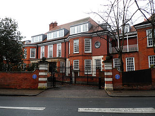
Gallery
 21-27 Well Walk, Hampstead
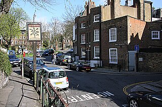
 Wells Tavern seen from Well Walk.
 1892 monument commemorating the historic Hampstead Wells.
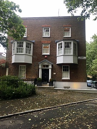
 Georgian era houses in the street.
Well Walk is a street in Hampstead, England in the London Borough of Camden. It runs southwestwards from Hampstead Heath to Flask Walk which then continues on towards the centre of Hampstead Village around the Hampstead tube station. It takes its name from the historic Hampstead Wells. [1]
Established in 1698 as a public wells, the area rapidly grew in popularity and a pump room was built along with an assembly room. Usage at the wells declined in the nineteenth century and the building was demolished, but is commemorated by a memorial fountain opposite it erected in 1882. [2] Wells Passage is a footpath that follows uphill from the fountain to the headspring in what is now Well Road. [3] The Wells Tavern was established in 1850, replacing an older public house known as The Green Man. [4] Burgh House is located just off the western end of the street in New End Square. Gainsborough Gardens runs southwards from the street.
Many of the buildings in the street are now Grade II listed generally dating from the early and late nineteenth century with some dating from the eighteenth. [5] [6] [7] [8] Notable former residents included the artist John Constable, who lived in the street from 1827 until his death in 1837 and whose house is now Grade II* listed, architect Temple Moore and early Socialist politician Henry Hyndman. [9] Constable and Hyndman's houses are commemorated with blue plaques. [10] [11]
Nos. 21-27, formerly called Foley Avenue, are an eclectic pair of semi-detached houses designed by Henry Simpson Legg, architect and surveyor for the Hampstead Wells Trust. The houses were a speculative development by Edward Gotto, who lived in The Logs, Well Road. [12]
In 1774 Roman pottery was discovered in the street, suggesting that a Roman road may have run through Hampstead. [13]


Belsize Park Gardens is a street in the Belsize Park area of Hampstead in London. Located in the London Borough of Camden, it is residential street featuring white stucco Victorian era buildings. It runs roughly southeastwards from Belsize Avenue in Belsize Village before terminating at a junction with Eton Avenue, England's Lane and Primrose Hill Road. The Grade II listed pub The Washington, dating from around 1865, is located at its eastern end.

Chalcot Square is a garden square in the Primrose Hill district of London, England.

Carlton Vale is a street that runs through Kilburn and Maida Vale in London. Some of its route forms the boundary between the City of Westminster to the south and the London Borough of Brent to the north. To the west the street continues as Kilburn Lane through Queen's Park, while to the east it becomes Carlton Hill running into St. John's Wood. Carlton Vale crosses or meets several roads including Kilburn Park Road, Cambridge Road and Randolph Avenue.

Norfolk Square is a rectangular garden square in Paddington in Central London. Located in the City of Westminster, it is part of the Tyburnia district north of Hyde Park. It runs east to west from London Street to Norfolk Place. Praed Street and Sussex Gardens are directly parallel to it north and south respectively.

Oakley Square is a crescent-shaped garden square in Somers Town in Central London, close to Mornington Crescent and Camden Town. It is located in the London Borough of Camden and runs roughly northeastwards from Eversholt Street meeting with the southern end of Camden Street on its eastern side.

Eton Avenue is a street in the Belsize Park area of Hampstead in North London. Located in the London Borough of Camden, it runs eastward from Swiss Cottage tube station to a junction with England's Lane, Primrose Hill Road and Belsize Park Gardens by The Washington pub. Fellows Road and Adelaide Road run parallel to the south of Eton Avenue.

Well Road is a street in Hampstead, England in the London Borough of Camden. It runs westwards from Hampstead Heath to New End Square. Well Walk runs parallel to its south and the two are linked by Wells Passage. When the Hampstead Wells were in existence, a large pump room and assembly room were located on Well Walk, with the water supplied from the headspring on Well Road.

New End Square is a square in Hampstead, in the London Borough of Camden. It dates back to the early eighteenth century when it was located close to the Hampstead Wells spa on the adjacent Well Walk. Despite its name it is not rectangular. At its northern end is the Old White Bear pub dating back to 1704, on the corner with Well Road. Its southern end is at the junction between Flask Walk and Well Walk. New End street curls off from one corner of the square, eventually heading west to Heath Street.

Flask Walk is a street in Hampstead in the London Borough of Camden. It runs eastwards from Hampstead High Street to a junction with Well Walk and New End Square. It is primarily residential but the western end of the street is a pedestrianised alley featuring commercial properties. Hampstead tube station is located close to the junction with the High Street.

Pond Street is located in Hampstead in the London Borough of Camden. It runs eastwards from Rosslyn Hill to South End Green, located in the old "South End" of the settlement. The street takes its name from an ancient pond at South End Green, a source of the River Fleet, and has been known by this name since at least 1678. The pond survived into the Victorian era.
North End Way is a street in Hampstead in the London Borough of Camden, today a stretch of the A502 road. At the boundary with the London Borough of Barnet it becomes North End Road running northwards into Golders Green where it terminates at the junction with Finchley Road, by the tube station. North End Way passes through Hampstead Heath.

Hampstead Grove is a street in Hampstead in the London Borough of Camden. It heads northwards from Holly Hill running towards Hampstead Heath, but curving back towards Lower Terrace which connects it to the Heath. It runs roughly parallel to Heath Street to its east. It takes its name from the groves of trees that marked the landscape.
Holly Hill is a street in Hampstead in the London Borough of Camden. It runs northwards from a junction with Hampstead High Street and Heath Street, Hampstead heading uphill to a grassy triangle named Holly Bush Hill where it meets Windmill Hill and Hampstead Grove by the entrance to Fenton House. It takes its name from a grove of holly bushes which stood on the hill until the 1940s. In the eighteenth century it was known as Cloth Hill, likely because local laundresses using Hampstead Wells hung their clothes out on the Holly Bushes to dry. Holly Mount turns eastwards off the street and forms a cul-de-sac, although there are steps linking it to Heath Street below. Holly Mount contains The Holly Bush pub, which was once linked to the nearby assembly rooms. Notable residents of Holly Hill have included the artists George Romney and Derek Hill, both commemorated with blue plaques. A number of properties are now Grade II listed. Romney's House at 5 Holly Bush Hill is Grade I listed. Running uphill to the west is Mount Vernon which also features notable historic properties and Holly Walk.

Maresfield Gardens is a street in Hampstead. Located in the London Borough of Camden, it runs parallel to the west of Fitzjohns Avenue for much of its route before curving to join it at is southern end. It crosses Nutley Terrace and Netherhall Gardens. The Belsize Tunnel passes underneath the street. It primarily feature red brick buildings.

Broadhurst Gardens is a street in the London Borough of Camden running eastwards from West End Lane in West Hampstead and ending near to the Finchley Road. It forms the northern border of South Hampstead, and runs parallel to the Midland Main Line. It meets or is crossed by Priory Road, Fairhazel Gardens and Canfield Gardens.

Branch Hill is a street in Hampstead. Located in the London Borough of Camden it is named after a hill on Hampstead Heath and runs adjacent to the heath between Frognal Rise and West Heath Road. Branch Hill, then largely open countryside, was a favourite landscape of the artist John Constable and he painted it on a number of occasions. Branch Hill Pond is located close to the junction with West Heath Road, while it dried up in the early twentieth century recent efforts have been made to restore it.

Fitzjohns Avenue is a street in Hampstead, England. Located in the London Borough of Camden it runs northwards from College Crescent to join and become Heath Street in Hampstead Village. Running steeply uphill for much of its route Fitzjohns Avenue is joined or crossed by various other streets including Belsize Park, Belsize Lane, Maresfield Gardens, Netherhall Gardens, Akenfield Road and Lyndhurst Road. It is classified as part of the B511 road. It is also sometimes written as Fitzjohn's Avenue.

Delancey Street is a mainly residential street in Camden Town, London, England. Located in the London Borough of Camden, it runs roughly west to east in a curve from Camden High Street to Parkway. It is met or crossed by Arlington Road, Albert Street, Gloucester Avenue, and Mornington Terrace. Eastwards of Camden High Street the route continues as Pratt Street as far as the Regent's Canal.

Mornington Terrace is a street in Camden Town. Located in the London Borough of Camden, it runs southeastwards from Delancey Street following the route of the main line into Euston that runs immediately to its west. At its southern end it becomes Clarkson Row while Mornington Place connects it to Mornington Crescent. Both Mornington Terrace and Place are notable for their surviving Victorian houses.
Pond Square is a garden square and village green in Highgate, London. Located close to Highgate High Street and The Gatehouse it is today in the London Borough of Camden. Swain's Lane runs off the square heading downhill past Highgate Cemetery.
51°33′32″N0°10′23″W / 51.559°N 0.173°W
| | This London road or road transport-related article is a stub. You can help Wikipedia by expanding it. |