The M1 De Villiers Graaff motorway is a metropolitan route and major freeway in the City of Johannesburg, South Africa. The highway connects the southern areas with the city centre and extends further north through Sandton into the Ben Schoeman Highway towards Pretoria. Construction began in 1962 and resulted in the demolition of many properties and houses including numerous historical Parktown Mansions.
The Freedom Shop is the name of an anarchist infoshop which distributes books and information, based in Wellington, New Zealand. It operates on a non profit basis, injecting any income back into the project. The shop has been based in different locations and mainly sells books on anarchism, feminism, indigenous rights, ecology and a range of activist issues. It also carries patches, badges, clothing and music.
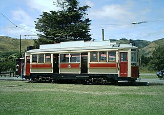
The Wellington tramway system (1878–1964) operated in Wellington, the capital of New Zealand. The tramways were originally owned by a private company, but were purchased by the city and formed a major part of the city's transport system.

The Mount Victoria Tunnel in the New Zealand capital city of Wellington is 623 metres long and 5 metres (16.4 ft) in height, connecting Hataitai to the centre of Wellington and the suburb of Mount Victoria, under the mount of the same name. It is part of State Highway 1.

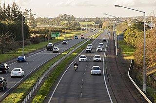
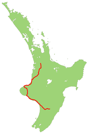
State Highway 1 is the longest and most significant road in the New Zealand road network, running the length of both main islands. It appears on road maps as SH 1 and on road signs as a white number 1 on a red shield, but it has the official designations SH 1N in the North Island, SH 1S in the South Island.
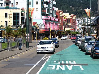
Te Aro is an inner-city suburb of Wellington, New Zealand. It comprises the southern part of the central business district including the majority of the city's entertainment district and covers the mostly flat area of city between The Terrace and Cambridge Terrace at the base of Mount Victoria.

Courtenay Place is the main street of the Courtenay Quarter in the Wellington inner-city district of Te Aro.

The Central Motorway Junction or CMJ, is the intersection of State Highways 1 and 16, just south of the central business district of Auckland. A multilevel structure, it has been described as a "fiendishly complicated, multi-layered puzzle of concrete, steel and asphalt". Carrying around 200,000 vehicles a day, it is one of the busiest stretches of road in New Zealand.
Transport in Auckland, New Zealand's largest city, is defined by factors that include the shape of the Auckland isthmus, the suburban character of much of the urban area, a history of focusing investment on roading projects rather than public transport, and high car-ownership rates.

The Terrace Tunnel takes the Wellington Urban Motorway (SH1) under The Terrace in central Wellington, New Zealand. Opened in 1978, it is 460 metres in length.

The Auckland Northern Motorway in the Auckland Region of New Zealand links Central Auckland and Warkworth in the former Rodney District via the Hibiscus Coast and North Shore. It is part of State Highway 1.
The Auckland Southern Motorway is the major route south out of the Auckland Region of New Zealand. It is part of State Highway 1.

The Wellington Urban Motorway, part of State HIghway 1, is the main road into and out of Wellington, New Zealand. It is 7 km long, ranges from three to seven lanes wide, and extends from the base of the Ngauranga Gorge into the Wellington CBD.

The Johnsonville–Porirua Motorway is a motorway in Wellington, New Zealand. The majority of the motorway forms part of State Highway 1, the main route of traffic in and out of the city, with the northernmost 2.1 km (1.3 mi), formerly part of SH 1 until 7 December 2021, designated as State Highway 59. Completed in the 1950s, it was New Zealand's first motorway.
State Highway 3 (SH 3) is one of New Zealand's eight national state highways. It serves the west coast of the country's North Island and forms a link between State Highway 1 and State Highway 2. Distances are measured from north to south.

The Victoria Park Tunnel is a motorway tunnel completed in 2012 on New Zealand State Highway 1 in Auckland, New Zealand, taking northbound traffic off the Victoria Park Viaduct, which was converted to all southbound traffic. It lies mostly under Victoria Park.
WestConnex in Sydney, Australia is the largest and longest road tunnel in the world which is currently in use, with a length of 26 km. A joint project of the New South Wales and Australian Federal governments, the motorway scheme created around 33 kilometres (21 mi) motorway with 6-10 lanes between Homebush and Kingsgrove, passing underneath Inner West suburbs including Haberfield and St Peters. The first of the tunnels, the M4 East, opened to traffic in July 2019. The second of the tunnels, the M8 Motorway, opened to traffic a year later in July 2020. The third of the tunnels which extend the M4 and M8 opened to traffic in January 2023. The final component of the scheme, the Rozelle Interchange, opened to traffic in November 2023.

The Auckland Airport Line is a proposed heavy rail line in Auckland, New Zealand, that would link Auckland Airport with the Auckland central business district via central isthmus suburbs.


