 Australia Tower on the top of Mount Wellington
 Mount Wellington hiking track and Organ Pipes
 Mount Wellington lookout and boardwalk
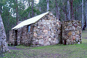 One of the huts on the slopes of Mount Wellington
| Wellington Park | |
|---|---|
 Hobart with Mount Wellington in the background | |
 | |
| Nearest city | Hobart |
| Coordinates | 42°53′S147°10′E / 42.89°S 147.16°E [1] |
| Area | 182.5 [2] |
| Established | November 1, 1993 |
| Visitors | 280,491 [3] |
| Operator | Wellington Park Management Trust |
| www | |
Wellington Park is a protected area which encompasses kunanyi / Mount Wellington and surrounds near Hobart, Tasmania. There are numerous hiking and mountain bike tracks within the park of varying difficulty.


