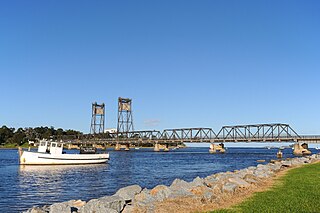
The Clyde River is an open intermediate tide-dominated drowned valley estuary or perennial river that flows into the Tasman Sea at Batemans Bay, located in the South Coast region of New South Wales, Australia.
The Greenough River is a river in the Mid West region of Western Australia.
Bremer River is a river in Western Australia that rises near Jerramungup at the border of the Yilgarn plateau. The river flows in a generally south-easterly direction and the river valley becomes steadily deeper as the river approaches the coast, where it has eroded the Pallinup siltstone deposits that deposited over the underlying granite.

The Fitzgerald River is a river in the Great Southern region of Western Australia.

Wilson Inlet is a shallow, seasonally open estuary located on the coast of the Great Southern region of Western Australia.
Broke Inlet, originally named Broke's Inlet, is an inlet in the South West region of Western Australia located 19 kilometres (12 mi) west of Walpole.

Stokes Inlet is an inlet in the Goldfields-Esperance region of Western Australia.

The Fortescue River is an ephemeral river in the Pilbara region of Western Australia. It is the third longest river in the state.

Walcott Inlet is an estuary located in the Kimberley region of Western Australia. It flows into Collier Bay, in the Indian Ocean, via a narrow gap known as Yule Entrance.
Irwin Inlet is an inlet in the located on the Great Southern region of Western Australia.

Hardy Inlet is an inlet that is located in the South West region of Western Australia.
Gordon Inlet is an estuarine inlet, located in the Great Southern region of Western Australia. The inlet is at the south west corner of the Fitzgerald River National Park and approximately 15 kilometres (9 mi) north west of the town of Bremer Bay.
The Hamersley River is an ephemeral river in the Great Southern region of Western Australia.
Torbay Inlet is an estuarine inlet in the Great Southern region of Western Australia situated approximately 40 kilometres (25 mi) east of the town of Denmark, Western Australia.
Beaufort Inlet also locally known as Pallinup Estuary is an inlet located in the Great Southern region of Western Australia about 130 kilometres (81 mi) east of Albany.
The Tomaga River, an open mature wave dominated barrier estuary or perennial stream, is located in the South Coast region of New South Wales, Australia.

The Tuross River, an open semi-mature wave dominated barrier estuary or perennial stream, is located in the South Coast region of New South Wales, Australia.
The Tarwin River is a perennial river of the West Gippsland catchment, located in the South Gippsland region of the Australian state of Victoria. The Tarwin River is the primary river system within South Gippsland Shire and has a catchment area of approximately 1,500 square kilometres (580 sq mi), predominantly rural with small pockets of residential land use. It flows south from the Strzlecki Ranges and discharges in the eastern reaches of Anderson Inlet, a shallow estuary connected to Bass Strait.
Taylor Inlet is an inlet located in the Great Southern region of Western Australia. The inlet is located on the coast near Nanarup Beach and is approximately 23 kilometres (14 mi) east of Albany and is contained within the Taylor Inlet nature reserve.


