
The Moselle is a river that rises in the Vosges mountains and flows through north-eastern France and Luxembourg to western Germany. It is a left bank tributary of the Rhine, which it joins at Koblenz. A small part of Belgium is in its basin as it includes the Sauer and the Our.

Eltz Castle is a medieval castle nestled in the hills above the Moselle between Koblenz and Trier, Germany. It is still owned by a branch of House of Eltz who have lived there since the 12th century. Eltz Castle along with Bürresheim Castle and Lissingen Castle are the only castles in the Eifel region which have never been destroyed.
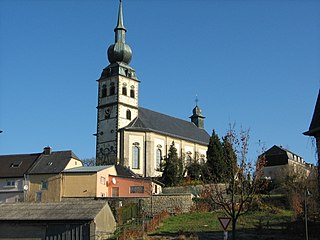
Koerich is a commune and village in western Luxembourg. It is part of the canton of Capellen.

Gerolstein is a town in the Vulkaneifel district of Rhineland-Palatinate, Germany. Gerolstein is a local municipality of the Verbandsgemeinde Gerolstein. It has been approved as a Luftkurort.

Ulmen is a town in the Cochem-Zell district in Rhineland-Palatinate, Germany. It is the seat of the like-named Verbandsgemeinde – a kind of collective municipality – to which it also belongs.
Kastellaun Castle is a ruined medieval castle in Kastellaun in the Rhein-Hunsrück district in Rhineland-Palatinate, Germany.
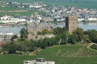
Klopp Castle is a castle in the town of Bingen am Rhein in the Upper Middle Rhine Valley in Rhineland-Palatinate, Germany. In the nineteenth century, the bergfried from the original medieval fortified castle was restored and a new building added which houses the town's administration.
Lissingen Castle is a well-preserved former moated castle dating to the 13th century. It is located on the River Kyll in Gerolstein in the administrative district of Vulkaneifel in Rhineland-Palatinate, Germany. From the outside it appears to be a single unit, but it is a double castle; an estate division in 1559 created the so-called lower castle and upper castle, which continue to have separate owners. Together with Bürresheim and Eltz, it has the distinction among castles in the Eifel of never having been destroyed.

Grubenhagen Castle is the ruin of a lowland castle in Schloß Grubenhagen, a village in the civil parish of Vollrathsruhe in the county of Mecklenburgische Seenplatte in Mecklenburg-Western Pomerania in Germany.

Blens Castle stands at a height of 205 m above sea level (NHN) on the eastern edge of Blens, a town quarter of Heimbach (Eifel) above the River Rur in the county of Düren, in the German state of North Rhine-Westphalia.

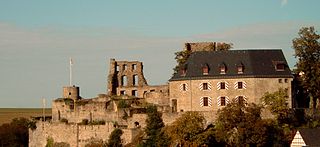
The ruins of the Thurant Castle stand on a wide slate hill spur above the villages of Alken on the Moselle in Germany. The castle is in the district of Mayen-Koblenz in Rhineland-Palatinate and belongs to the spur castle type. Vine gardens on the sunniest slope.

The Old Castle was a former Elector-owned, substantial water castle in the German city of Koblenz, incepted in the 13th century. It is today reduced to the later Burghaus ; which houses the city archives. It sits on tall foundations and has a tall, black slate roof with further floors in the attic and two small cupolas. The lowland castle abutted the remaining building in the old town quarter. The castle house stands tall, next to the Moselle's right-bank towpath downstream of the strategic Baldwin Bridge built in 1342. The bridge, much-repaired, remains intact.
Egloffstein Castle is a former high mediaeval, aristocratic castle, that stands immediately west of the eponymous village of Egloffstein in the Upper Franconian county of Forchheim in the German state of Bavaria.

Pyrmont Castle stands west of Münstermaifeld near Roes and Pillig on a slate rock outcrop above a waterfall on the Elzbach in the southern Eifel mountains in Germany. It is in the municipality of Roes in the district of Cochem-Zell.

The ruins of Ramstein Castle stand on a 182-metre-high, Bunter sandstone rock on the edge of the Meulenwald forest in the lower, steep-sided Kyll valley near Kordel in the German state of Rhineland-Palatinate. It stands 9 kilometres (5.6 mi) north of Trier and the same east of Luxembourg.

Wernerseck Castle, also called the Kelterhausburg, is a late medieval hill castle in the municipality of Ochtendung in the county of Mayen-Koblenz in the German state of Rhineland-Palatinate. It owes its name to its founder and lord of the castle, the Archbishop of Trier, Werner of Falkenstein (1388–1418). "Wernerseck" means "Werner's corner".

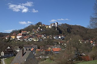
On a hill spur above the Eifel village of Monreal in Germany's Elzbach valley, at a height of 350 m above sea level (NHN), stand two neighbouring ruined hill castles: the Löwenburg, also called Monreal Castle, and the Philippsburg. The latter is also known locally as das Rech.

The ruins of Nideggen Castle are a symbol of the town of Nideggen in Germany and are owned by the county of Düren. The rectangular hill castle was the seat of the powerful counts and dukes of Jülich and had a reputation in the Middle Ages of being impregnable.

Eltville Castle is an urban castle in Eltville am Rhein im the Hessian county of Rheingau-Taunus and is the symbol of the town. In German the castle is also known as the Kurfürstliche Burg.
This page is based on this
Wikipedia article Text is available under the
CC BY-SA 4.0 license; additional terms may apply.
Images, videos and audio are available under their respective licenses.


