Wenum-Wiesel

Last updated
Wenum-Wiesel
Twin village
20160421 landgoed De Ploeg2 Wenum-Wiesel.jpg
Estate "De Ploeg"
2010-NL-P05-Gelderland-positiekaart-gemnamen.jpg
Red pog.svg
Wenum-Wiesel
Location in the province of Gelderland
Netherlands location map.svg
Red pog.svg
Wenum-Wiesel
Wenum-Wiesel (Netherlands)
Coordinates: 52°15′13″N5°57′15″E / 52.2537°N 5.9542°E / 52.2537; 5.9542 Coordinates: 52°15′13″N5°57′15″E / 52.2537°N 5.9542°E / 52.2537; 5.9542
Country Netherlands
Province Gelderland
Municipality Apeldoorn
Area
[1]
  Total30.65 km2 (11.83 sq mi)
Elevation
[2]
16 m (52 ft)
Population
 (2021) [1]
  Total2,170
  Density71/km2 (180/sq mi)
Time zone UTC+1 (CET)
  Summer (DST) UTC+2 (CEST)
Postal code
7345 [1]
Dialing code 055

Wenum-Wiesel is a twin village in the municipality of Apeldoorn, in the province of Gelderland in the Netherlands. In 1978, the hamlets of Wenum and Wiesel merged into a village.

Contents

History

Wenum was first attested in 1335 as "in der Merck to Wenen", [3] however the watermill was already mentioned in 1313. [4] The etymology of the name is unclear. [3] Wiesel was first attested in 1337 as Wiessel, and means pasture near a forest. [5]

In 1684, William III of Orange bought approximately 100 square kilometres (39 sq mi) of forest and heath in the area as a crown land. The land included the village of Wiesel. He intended to build his palace in Hoog Soeren, but changed his mind and bought Het Loo Palace in Apeldoorn. [6] [7] In 1840, Wenum was home to 256 people, and Wiesel to 243 people. [8]

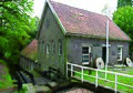
In 1876, the Amsterdam–Zutphen railway was completed, and William III of the Netherlands wanted a side track to his palace. In 1887, the Apeldoorn–Zwolle railway line was completed and partially used the side track. A railway stop was constructed at Wenum. The station closed in 1938. [9] [10] In 1840, the gristmill Grondzeiler Wenum  [ nl ] was built in Wenum. The current windmill dates from 1913. [11]

In 1978, the hamlets of Wenum and Wiesel merged into the twin village Wenum-Wiesel. The hamlets are still somewhat separated. The place name signs are chaotic and sometimes use the combined name, or the individual hamlet. The village has a combined school, and village council. [8]

Related Research Articles

Apeldoorn City and Municipality in Gelderland, Netherlands

Apeldoorn is a municipality and city in the province of Gelderland in the centre of the Netherlands. It is a regional centre. The municipality of Apeldoorn, including villages like Beekbergen, Loenen, Ugchelen and Hoenderloo, had a population of 165.525 on 1 december 2021. The western half of the municipality lies on the Veluwe ridge, the eastern half lies in the IJssel valley.

Zuuk Hamlet in Gelderland, Netherlands

Zuuk is a hamlet in the Netherlands, south of Zwolle, in the province of Gelderland in the municipality of Epe.

Vilsteren Village in Overijssel, Netherlands

Vilsteren is a village in the municipality of Ommen in the Dutch province of Overijssel. It is situated just off the left bank of the Vecht in between Dalfsen and Ommen, about 17 kilometres east of the provincial capital of Zwolle.

Reutum Place in Overijssel, Netherlands

Reutum is a village in the Dutch province of Overijssel. It is a part of the municipality of Tubbergen, and lies about 10 km northwest of Oldenzaal.

Wissel Hamlet in Gelderland, Netherlands

Wissel is a hamlet in the Dutch province of Gelderland. It is located in the municipality of Epe, about 2 km west of the town of Epe.

Adorp Village in Groningen, Netherlands

Adorp is a village in the municipality of Het Hogeland, Netherlands. It is located about 6 km north of Groningen. Until 1990, Adorp was a separate municipality, however the seat was in Sauwerd.

Noord-Sleen Village in Drenthe, Netherlands

Noord-Sleen is a village in the Netherlands and is part of the Coevorden municipality in Drenthe.

Oosterwolde, Gelderland Village in Gelderland, Netherlands

Oosterwolde is a village in the Dutch province of Gelderland. It is located in the municipality of Oldebroek, about 15 km southwest of Zwolle. Oosterwolde was a separate municipality until 1818, when it was merged with Doornspijk.

Stroe, Gelderland Village in Gelderland, Netherlands

Stroe is a village in the Dutch province of Gelderland. It is located in the municipality of Barneveld, between the towns of Barneveld and Apeldoorn.

Roderwolde Village in Drenthe, Netherlands

Roderwolde is a village in the Netherlands and is part of the Noordenveld municipality in Drenthe.

Assel, Gelderland Hamlet in Gelderland, Netherlands

Assel is a hamlet in the municipality of Apeldoorn in the Netherlands, located close to the village of Hoog Soeren.

Hoenderloo Village in Gelderland, Netherlands

Hoenderloo is a Dutch village located south west of the city of Apeldoorn. Most of the village is part of the municipality of Apeldoorn, but a small part belongs to the municipality of Ede, among which the hamlet Hoog Baarlo.

Mastenbroek Polder and hamlet in Overijssel, Netherlands

Mastenbroek is a polder in the Dutch province of Overijssel. It lies north of the city of Zwolle. "Mastenbroek" is also the name of an hamlet, built around a church in the middle of the polder.

Jonas, Netherlands Hamlet in Gelderland, Netherlands

Jonas is a hamlet in the Dutch province of Gelderland. It lies east of the village of Vaassen, on the western side of the Apeldoornsch Kanaal.

De Heurne Village in Gelderland, Netherlands

De Heurne is a village in the municipality of Aalten, near Dinxperlo, Province of Gelderland, in the east of the Netherlands.

Hoog Soeren Village in Gelderland, Netherlands

Hoog Soeren is a village in the municipality of Apeldoorn, in the province of Gelderland in the Netherlands. Since 1863, it is a crown land.

Terschuur Village in Gelderland, Netherlands

Terschuur is a village in the Dutch province of Gelderland. It is located in the municipality of Barneveld.

Kootwijk Village in Gelderland, Netherlands

Kootwijk is a small village in the municipality Barneveld, located in the middle of the Netherlands, in the province of Gelderland.

Ooij, Berg en Dal Village in Gelderland, Netherlands

Ooij is a village in the eastern Netherlands. It is located in the municipality of Berg en Dal, Gelderland.

Nieuw-Milligen Hamlet in Gelderland, Netherlands

Nieuw-Milligen is a hamlet in the municipality of Apeldoorn in the province of Gelderland, the Netherlands. Nieuw-Milligen is best known for Air Operations Control Station Nieuw-Milligen, a military air traffic control centre in the Netherlands. The base started out as a small military airfield in 1913 and remained in use as such until 1940, when it was destroyed by the Dutch military to prevent it from being used by the Germans. It is also home to a Landal Greenparks holiday village.

References

  1. 1 2 3 "Kerncijfers wijken en buurten 2021". Central Bureau of Statistics. Retrieved 19 March 2022. The hamlet Beemte-Broekland  [ nl ] (1,035 inhabitants - 12.79 km2) has been subtracted from the total
  2. "Postcodetool for 7345AA". Actueel Hoogtebestand Nederland (in Dutch). Het Waterschapshuis. Retrieved 19 March 2022.
  3. 1 2 "Wenum - (geografische naam)". Etymologiebank (in Dutch). Retrieved 19 March 2022.
  4. Ronald Stenvert & Sabine Broekhoven (2000). "Apeldoorn" (in Dutch). Zwolle: Waanders. p. 78. ISBN   90 400 9406 3 . Retrieved 19 March 2022.
  5. "Wiesel - (geografische naam)". Etymologiebank (in Dutch). Retrieved 19 March 2022.
  6. "Hoog Soeren - (geografische naam)". Etymologiebank (in Dutch). Retrieved 19 March 2022.
  7. "Wieselsche bosch (Kroondomein)" (PDF). IVN Apeldoorn (in Dutch). Retrieved 19 March 2022.
  8. 1 2 "Wenum-Wiesel". Plaatsengids (in Dutch). Retrieved 19 March 2022.
  9. "Trein". Gelderland Binnenste Buiten (in Dutch). Archived from the original on 7 April 2014. Retrieved 19 March 2022.
  10. "Station Wenum". Stationsweb (in Dutch). Retrieved 19 March 2022.
  11. "Wenum, Gelderland". Molendatabase (in Dutch). Retrieved 19 March 2022.