
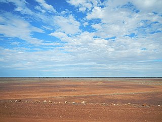
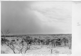
The desert climate or arid climate, is a climate in which there is an excess of evaporation over precipitation. The typically bald, rocky, or sandy surfaces in desert climates hold little moisture and evaporate the little rainfall they receive. Covering 14.2% of earth's land area, hot deserts are the second most common type of climate on earth after polar climate.
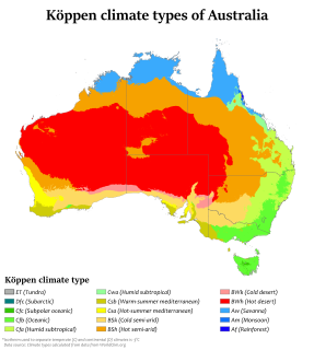
Australia's climate is governed mostly by its size and by the hot, sinking air of the subtropical high pressure belt. This moves north-west and north-east with the seasons. The climate is variable, with frequent droughts lasting several seasons, thought to be caused in part by the El Niño-Southern Oscillation. Australia has a wide variety of climates due to its large geographical size. The largest part of Australia is desert or semi-arid. Only the south-east and south-west corners have a temperate climate and moderately fertile soil. The northern part of the country has a tropical climate, varying between grasslands and desert. Australia holds many heat-related records: the continent has the hottest extended region year-round, the areas with the hottest summer climate, and the highest sunshine duration.
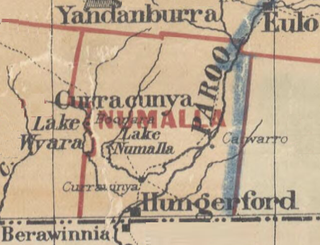
Numalla County is a cadastral division of Queensland and a County of the Warrego Land District of southwestern Queensland.

Nickavilla County is a cadastral division of Queensland and a County of the Warrego Land District of southwestern Queensland.
Grey County is a cadastral division of Queensland and a County of the South Gregory District of remote western Queensland. The county is divided into civil parishes.
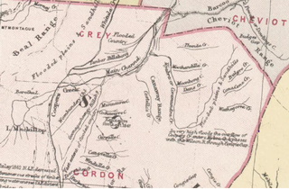
Gordon County is a cadastral division of Queensland, Australia and a County of the South Gregory District of remote western Queensland. The county is divided into civil parishes.
Wyara County, Queensland is a cadastral division of Queensland and a County of remote western Queensland.

Paroo County, Queensland is a cadastral division of Queensland and a County of the Warrego Land District of southwestern Queensland.

Portland County, Queensland is a cadastral division of Warrego Land District of Southern Queensland and a County of Queensland, Australia.

Sturt County, Queensland is a cadastral division of North Gregory District of Western Queensland and a County of Queensland, Australia.
Daroo County, Queensland is a cadastral division of Warrego Land District of Southern Queensland and a County of Queensland, Australia.

Durrie County Queensland is a cadastral division of Warrego Land District of Southern Queensland and a County of Queensland, Australia. The county is divided into civil parishes.
Weramo County Queensland is a cadastral division of Warrego Land District of western Queensland aa locality and a County of Queensland, Australia. Weramo County is in the arid centre of the continent.

County of Carnarvon is one of the 318 counties of Queensland, Australia. It is within the Darling Downs region west Brisbane.

Nyama County, Queensland is one of the 318 counties of Queensland, Australia. It is within the

Ayrshire County, Queensland is one of the 318 counties of Queensland, Australia. It is within the The county came into existence in the 19th century, and on 8 March 1901, the Governor of Queensland issued a proclamation legally dividing Queensland into counties under the Land Act 1897. Like all counties in Queensland, it is a non-functional administrative unit, that is used mainly for the purpose of registering land titles. From 30 November 2015, the government no longer referenced counties and parishes in land information systems however the Museum of Lands, Mapping and Surveying retains a record for historical purposes.
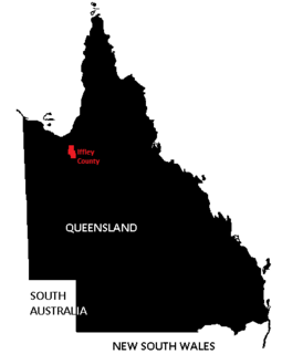
Iffley County, Queensland is one of the 318 counties of Queensland, Australia. The county is divided into civil parishes. It is within the The county came into existence in the 19th century, and on 8 March 1901, the Governor of Queensland issued a proclamation legally dividing Queensland into counties under the Land Act 1897.
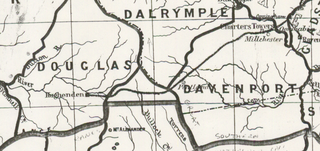
Dalrymple County, Queensland is one of the 318 counties of Queensland, Australia. The county came into existence in the 19th century, and on 8 March 1901, the Governor of Queensland issued a proclamation legally dividing Queensland into counties under the Land Act 1897. Like all counties in Queensland, it is a non-functional administrative unit, that is used mainly for the purpose of registering land titles. From 30 November 2015, the government no longer referenced counties and parishes in land information systems however the Museum of Lands, Mapping and Surveying retains a record for historical purposes.
Douglas County, Queensland is one of the 318 counties of Queensland, Australia. The county is divided into civil parishes. The county came into existence in the 19th century, and on 8 March 1901, the Governor of Queensland issued a proclamation legally dividing Queensland into counties under the Land Act 1897. Like all counties in Queensland, it is a non-functional administrative unit, that is used mainly for the purpose of registering land titles. From 30 November 2015, the government no longer referenced counties and parishes in land information systems however the Museum of Lands, Mapping and Surveying retains a record for historical purposes.
Yappar County, Queensland is a cadastral division of Burke District of northern Queensland and a County of Queensland, Australia.

