Museum of Lands, Mapping and Surveying

Last updated

Compass theodolite, Museum of Lands, Mapping and Surveying Compass theodolite.jpg
Compass theodolite, Museum of Lands, Mapping and Surveying

The Museum of Lands, Mapping and Surveying is a museum at 317 Edward Street, Brisbane, Queensland, Australia. It collects and exhibits material relating to the surveying of Queensland and the maps created. It is a sub-branch of the Queensland Museum. [1] [2] It actively digitises and makes available historic maps and aerial imagery under open licences. [3]

Contents

Collections

Land exploration and surveying has played a crucial role in the development of Queensland. Surveyors and cartographers played an active part in establishing Queensland's borders, physically surveying the land as well as creating maps, survey plans and registers. [4]

The historical input of the surveying and mapping industry to the development of Queensland is an important factor in the role the department plays in providing a valuable resource for a wide range of community interests and government. [4]

In its short history the museum has established a comprehensive collection, housing many important maps, survey plans and artefacts, significant to the history of mapping, surveying and land development particularly in Queensland. [4]

The museum acquires, preserves, catalogues and displays information and artefacts pertaining to historical land settlement, surveying and cartographic activities in Queensland. [4]

Collection strategy

The museum aims to identify records, artefacts, maps and plans that are useful in filling gaps in the knowledge about the history of mapping and surveying in Queensland, and make such knowledge accessible. New material is constantly being identified as important for research purposes. [4]

Historical collections

The museum's physical and digital collections include:

History

The bust of Augustus Charles Gregory sculpted by Oscar Fristrom in 1905 stands at the entrance to the museum, 2020 Bust of Augustus Charles Gregory sculpted by Oscar Fristrom in 1905.jpg
The bust of Augustus Charles Gregory sculpted by Oscar Fristrom in 1905 stands at the entrance to the museum, 2020

In 1982, the Queensland Government through the Surveyor General of Queensland, JM Serisier ordered that a mapping and surveying museum be set up in order to preserve the mapping and surveying history of Queensland. The original museum was established in the Lands Administration Building, (now the Conrad Treasury Hotel), and Bill Kitson was tasked with establishing and operating the museum. [1]

With the support of the department and the mapping and surveying industry Kitson set about collecting artefacts, which were rapidly disappearing as technology overtook the traditional means of creating maps and surveys. The museum's collection grew from simply holding artefacts to include diaries, artwork, photographs and biographies which captured the personal and social history of those involved in surveying and mapping. Many historical maps of Queensland were also acquired. [1]

In 1987, the museum moved to the newly constructed Landcentre building in Woolloongabba. [1]

In 1988, in order to preserve the artefacts that had been collected an agreement was signed with the Queensland Museum to become custodian of the collections whilst the government provides staff to manage and run the museum. [1]

In 1991, the focus of the museum was broadened and it was renamed the Museum of Lands, Mapping and Surveying to include history of land development in Queensland. [1]

In 2018, the museum relocated to 317 Edward Street in the Brisbane CBD. [4]

In late 1905 Brisbane article Oscar Fristrom sculpted a bust of Augustus Charles Gregory, the first Surveyor-General of Queensland. [5] [6] In February 1906, Fristrom offered to sell the bust to the Royal Geographical Society of Queensland but the society decided not to buy it; [7] however, they did display it at an event in June 1906. [8] For many years the bust was displayed at Freemasons’ Gregory Lodge in Cairns (Gregory being depicted wearing his Masonic regalia). In 2018, the Freemasons donated the bust to the museum. [9] As at 10 March 2020, the bust is at the entrance of the museum.

See also

Related Research Articles

<span class="mw-page-title-main">Augustus Charles Gregory</span> Australian politician

Sir Augustus Charles Gregory was an English-born Australian explorer and surveyor. Between 1846 and 1858 he undertook four major expeditions. He was the first Surveyor-General of Queensland. He was appointed a lifetime Member of the Queensland Legislative Council.

<span class="mw-page-title-main">Queensland Museum</span>

The Queensland Museum Kurilpa is the state museum of Queensland, dedicated to natural history, cultural heritage, science and human achievement. The museum currently operates from its headquarters and general museum in South Brisbane with specialist museums located in North Ipswich in Ipswich, East Toowoomba in Toowoomba, and in Townsville City in Townsville.

<span class="mw-page-title-main">Haddon Corner</span> Historic site in Queensland, Australia

Haddon Corner is a heritage-listed site in Tanbar, Shire of Barcoo, Queensland, Australia. It is in outback Channel Country at South-West Queensland, on the border corner with South Australia. It was added to the Queensland Heritage Register on 9 November 2012.

<span class="mw-page-title-main">Lands administrative divisions of Queensland</span>

Lands administrative divisions of Queensland refers to the divisions of Queensland used for the registration of land titles. There are 322 counties, and 5,319 parishes within the state. They are part of the Lands administrative divisions of Australia. Queensland had been divided into 109 counties in the nineteenth century, before the Land Act of 1897 subdivided many of these counties to 319. Some of the eastern counties remained the same, with most of the subdivisions occurring in the west and north. The current counties were named and bounded by the Governor in Council on 7 March 1901.

<span class="mw-page-title-main">Oscar Fristrom</span> Australian painter

Carl Magnus Oscar Friström, generally known as Oscar Fristrom, was a portrait painter and art teacher born in Sweden, who had a substantial career in Queensland and South Australia, and was best known for his depictions of Aboriginal Australians.

<span class="mw-page-title-main">Cameron Corner Survey Marker</span> Historic site in Queensland, Australia

Cameron Corner Survey Marker is a heritage-listed survey marker in the locality of Cameron Corner, Shire of Bulloo, Queensland, Australia. The survey marker is at the border corner of South-West Queensland with New South Wales and South Australia; it was established in 1880. It was added to the Queensland Heritage Register on 9 November 2012.

<span class="mw-page-title-main">Poeppel Corner Survey Marker</span> Historic site in Queensland, Australia

Poeppel Corner Survey Marker is a heritage-listed survey marker at Poeppel Corner on the border corner of Queensland, South Australia and Northern Territory. In Queensland it is with the locality of Birdsville in the Shire of Diamantina. It was added to the Queensland Heritage Register on 9 November 2012.

<span class="mw-page-title-main">John Brewer Cameron</span>

John Brewer Cameron was a geodetic surveyor in Australia. He is best known for his survey of the border between Queensland and New South Wales. He also surveyed part of the border between South Australia and Western Australia.

James Warner (1814–1891) was a pioneer surveyor in Queensland, Australia. Arriving at Moreton Bay penal colony in 1838, he was one of three surveyors who surveyed the area now Brisbane and its surrounding areas. He worked for 50 years in the Survey Office of Queensland, surveying and naming many towns and other features.

<span class="mw-page-title-main">Kyabra County, Queensland</span> County in Queensland

Kyabra County, Queensland is a cadastral division of Queensland and a County of the South Gregory District of south western Queensland.

<span class="mw-page-title-main">Haddon County, Queensland</span>

Haddon County, Queensland is a cadastral division of Queensland, Australia. It is a county of the South Gregory District of far western Queensland. The county is divided into civil parishes.

<span class="mw-page-title-main">Porchester County, Queensland</span>

Porchester County, Queensland is a cadastral division and a County of Queensland located on the Gulf of Carpentaria adjacent to the Northern Territory border. The county is divided into civil parishes.

Burrandilla County is a cadastral division of Queensland and a County of the Warrego Land District of south western Queensland. The county is divided into civil parishes.

Palmer County is a cadastral division of Queensland and a County of the Warrego Land District of southwestern Queensland.

<span class="mw-page-title-main">Wyarra County, Queensland</span>

Wyarra County, Queensland is a cadastral division of Queensland, Australia and a County of the Warrego Land District of remote western Queensland.

<span class="mw-page-title-main">Gordon County, Queensland</span>

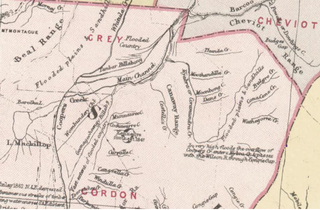
Gordon County is a cadastral division of Queensland, Australia and a County of the South Gregory District of remote western Queensland. The county is divided into civil parishes.

<span class="mw-page-title-main">Kendall County, Queensland</span>

Kendall County is a County of Queensland located at 13.683°S 141.967°E on the Cape York Peninsula in remote far north of Queensland, Australia.

Gowan County, Queensland is a cadastral division of Queensland and a County of the Warrego Land District of southwestern Queensland in Australia.

<span class="mw-page-title-main">Eyre County, Queensland</span> County of Queensland

Eyre County, Queensland is a cadastral division of North Gregory District of Western Queensland and a County of Queensland, Australia.

Yappar County, Queensland is a cadastral division of Burke District of northern Queensland and a County of Queensland, Australia.

References

  1. 1 2 3 4 5 6 "Museum history". Department of Natural Resources, Mines and Energy. Queensland Government. 13 March 2018. Archived from the original on 3 October 2018. Retrieved 3 October 2018.
  2. "History". Queensland Museum . Archived from the original on 3 October 2018. Retrieved 3 October 2018.
  3. "Historical cadastral map series—Queensland". Open Data Queensland. Queensland Government . Retrieved 4 October 2018.
  4. 1 2 3 4 5 6 "Collections and services". Queensland Government. 21 September 2018. Archived from the original on 3 October 2018. Retrieved 4 October 2018.
  5. "ART WORK". The Brisbane Courier . Queensland, Australia. 25 September 1905. p. 4. Retrieved 10 March 2020 via Trove.
  6. "ART EXHIBITION". The Queenslander . Queensland, Australia. 14 October 1905. p. 8. Retrieved 10 March 2020 via Trove.
  7. "Geographical Society". The Telegraph . Queensland, Australia. 17 February 1906. p. 2. Retrieved 10 March 2020 via Trove.
  8. "Geographical Society". The Telegraph . Queensland, Australia. 29 June 1906. p. 3. Retrieved 10 March 2020 via Trove.
  9. "Land Queensland". www.facebook.com. Retrieved 10 March 2020.

Attribution

This article was based on material from Collections and Services and Museum history published by The State of Queensland 2018 under CC-BY-4.0 license, accessed on 3 October 2018.

27°27′54″S153°01′30″E / 27.4651°S 153.0250°E / -27.4651; 153.0250 (Museum of Lands, Mapping and Surveying)